Eagle Township, Boone County, Indiana
Eagle Township is one of twelve townships in Boone County, Indiana.[3] As of the 2010 census, its population was 21,977 and it contained 8,231 housing units.[4]
Eagle Township | |
|---|---|
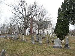 Salem United Methodist Church, located in a rural part of the township | |
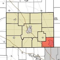 Location of Eagle Township in Boone County | |
| Coordinates: 39°57′27″N 86°17′44″W | |
| Country | United States |
| State | Indiana |
| County | Boone |
| Government | |
| • Type | Indiana township |
| Area | |
| • Total | 26.73 sq mi (69.2 km2) |
| • Land | 26.65 sq mi (69.0 km2) |
| • Water | 0.09 sq mi (0.2 km2) |
| Elevation | 928 ft (283 m) |
| Population (2010) | |
| • Total | 21,977 |
| • Density | 824.8/sq mi (318.5/km2) |
| Time zone | UTC-5 (Eastern (EST)) |
| • Summer (DST) | UTC-4 (EDT) |
| FIPS code | 18-19288[2] |
| GNIS feature ID | 453269 |
History
Pryor Brock Farmstead, Maplelawn Farmstead, Traders Point Eagle Creek Rural Historic District, and Traders Point Hunt Rural Historic District are listed on the National Register of Historic Places.[5][6]
Geography
According to the 2010 census, the township has a total area of 26.73 square miles (69.2 km2), of which 26.65 square miles (69.0 km2) (or 99.70%) is land and 0.09 square miles (0.23 km2) (or 0.34%) is water.[4]
Cities and towns
Unincorporated towns or communities
- Eagle Village
- Eaglewood Estates
- Fox Hollow
- Hamilton (historical)
- Royalton
- Russell Lake
- The Woodlands
(This list is based on USGS data and may include former settlements.)
Adjacent townships
- Perry (west)
- Union (north)
- Worth (northwest)
- Brown Township, Hendricks County (southwest)
- Clay Township, Hamilton County (east)
- Pike Township, Marion County (south)
- Washington Township, Hamilton County (northeast)
Cemeteries
The township contains six cemeteries: Clarkstown, Cox, Jones, Lincoln Memory Gardens, Pitzer, Salem and Sheets.
References
- "Eagle Township, Boone County, Indiana". Geographic Names Information System. United States Geological Survey. Retrieved 2009-09-24.
- United States Census Bureau cartographic boundary files
- "US Board on Geographic Names". United States Geological Survey. 2007-10-25. Retrieved 2008-01-31.
- "U.S. Census website". United States Census Bureau. Retrieved 2008-01-31.
- "Eagle Township, Boone County, Indiana". Geographic Names Information System. United States Geological Survey. Retrieved March 7, 2020.
- "Population, Housing Units, Area, and Density: 2010 - County -- County Subdivision and Place -- 2010 Census Summary File 1". United States Census. Archived from the original on 2020-02-12. Retrieved 2013-05-10.
- "National Register Information System". National Register of Historic Places. National Park Service. July 9, 2010.
- "National Register of Historic Places Listings". Weekly List of Actions Taken on Properties: 9/12/11 through 9/16/11. National Park Service. 2011-09-23.
External links
Municipalities and communities of Boone County, Indiana, United States | ||
|---|---|---|
| City | Map of Indiana highlighting Boone County | |
| Towns | ||
| Townships | ||
| Unincorporated communities | ||
| Footnotes | ‡This populated place also has portions in an adjacent county or counties | |