Dale, Boone County, Indiana
Dale is an unincorporated community in Center Township, Boone County, in the U.S. state of Indiana.[2]
Dale | |
|---|---|
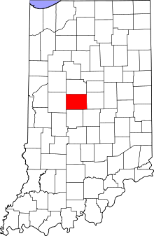 Boone County's location in Indiana | |
 Dale Location in Boone County | |
| Coordinates: 40°01′00″N 86°24′00″W | |
| Country | United States |
| State | Indiana |
| County | Boone |
| Township | Center |
| Elevation | 965 ft (294 m) |
| Time zone | UTC-5 (Eastern (EST)) |
| • Summer (DST) | UTC-4 (EDT) |
| ZIP code | 46052 |
| Area code(s) | 765 |
| GNIS feature ID | 446669 |
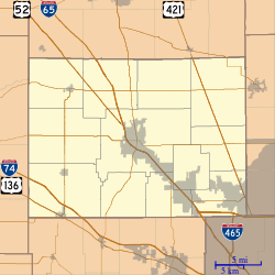
Geography
Dale is located at 40°01′00″N 86°24′00″W.
gollark: I can read *some* words in much of their stuff, because it's a weird mix of Chinese and English acronyms and things like "github star".
gollark: Yours has been tested and uses inferior bee neurons. Don't use it, people.
gollark: Here is the document: https://github.com/frotms/PaddleOCR2Pytorch. Please try and work out how I can use this æÆÆÆÆÆÆÆÆÆÆÆÆÆÆÆæææææÆÆÆÆÆææææÆÆÆÆÆÆÆÆÆÆÆÆÆÆ.
gollark: HelloBoi™ can be licensed from GTech™ for just 9125 kilobees per annum.
gollark: See, that isn't actually true. HelloBoi's parameters and inference code are proprietary GTech™ property.
References
- "US Board on Geographic Names". United States Geological Survey. 2007-10-25. Retrieved 2008-01-31.
- "Dale, Boone County, Indiana". Geographic Names Information System. United States Geological Survey. Retrieved March 7, 2020.
Municipalities and communities of Boone County, Indiana, United States | ||
|---|---|---|
| City | Map of Indiana highlighting Boone County | |
| Towns | ||
| Townships | ||
| Unincorporated communities | ||
| Footnotes | ‡This populated place also has portions in an adjacent county or counties | |
This article is issued from Wikipedia. The text is licensed under Creative Commons - Attribution - Sharealike. Additional terms may apply for the media files.