Stringtown, Boone County, Indiana
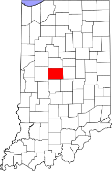
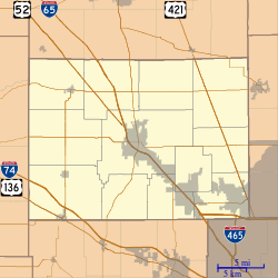
Stringtown is an unincorporated community in Center Township, Boone County, in the U.S. state of Indiana.[3]
Stringtown | |
|---|---|
 Boone County's location in Indiana | |
 Stringtown Location in Boone County | |
| Coordinates: 40°04′54″N 86°28′36″W | |
| Country | United States |
| State | Indiana |
| County | Boone |
| Township | Center |
| Elevation | 938 ft (286 m) |
| Time zone | UTC-5 (Eastern (EST)) |
| • Summer (DST) | UTC-4 (EDT) |
| ZIP code | 46052 |
| Area code(s) | 765 |
| FIPS code | 18-73700[2] |
| GNIS feature ID | 444272 |
History
The community was likely named for a strip of buildings laid out like a string.[4]
Geography
Stringtown is located at 40°04′54″N 86°28′36″W.
gollark: > why would they do thatPresumably, to get votes from the people living there.
gollark: pls whois <@560888972004556810>
gollark: They fire two wires or something, not a net, though.
gollark: Probably some plants.
gollark: Water, somewhat?
References
- "US Board on Geographic Names". United States Geological Survey. 2007-10-25. Retrieved 2008-01-31.
- "U.S. Census website". United States Census Bureau. Retrieved 2008-01-31.
- "Stringtown, Boone County, Indiana". Geographic Names Information System. United States Geological Survey. Retrieved March 6, 2020.
- Baker, Ronald L. (October 1995). From Needmore to Prosperity: Hoosier Place Names in Folklore and History. Indiana University Press. p. 315. ISBN 978-0-253-32866-3.
...a row of houses or buildings strung along a road without a real center.
This article is issued from Wikipedia. The text is licensed under Creative Commons - Attribution - Sharealike. Additional terms may apply for the media files.