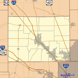
Dover, Boone County, Indiana
Dover is an unincorporated community in Jefferson Township, Boone County, in the U.S. state of Indiana.[2]
Dover | |
|---|---|
 Dover | |
| Coordinates: 40°03′16″N 86°37′12″W | |
| Country | |
| State | |
| County | Boone |
| Township | Jefferson |
| Elevation | 899 ft (274 m) |
| Time zone | UTC-5 (Eastern (EST)) |
| • Summer (DST) | UTC-4 (EDT) |
| ZIP code | 46071 |
| Area code(s) | 765 |
| GNIS feature ID | 433658 |
History
A post office was established at Dover in 1860, and remained in operation until it was discontinued in 1872.[3]
Geography
Dover is located at 40°03′16″N 86°37′12″W, at the intersection of IN 32 and IN 75, about 7 miles west of Lebanon.[4]
gollark: You can make one which always returns `null` or something. It says that conversion to language objects is implementation defined.
gollark: What are you actually selling? Some sort of hosted bot platform?
gollark: Pillow is the new actually working one.
gollark: A *true* moderator would never need it.
gollark: Perhaps the quiz is used to prevent people from becoming a certified moderator.
References
- "US Board on Geographic Names". United States Geological Survey. 2007-10-25. Retrieved 2008-01-31.
- "Dover, Boone County, Indiana". Geographic Names Information System. United States Geological Survey. Retrieved March 1, 2020.
- "Benton County". Jim Forte Postal History. Retrieved March 1, 2020.
- http://indiana.hometownlocator.com/in/boone/dover.cfm
This article is issued from Wikipedia. The text is licensed under Creative Commons - Attribution - Sharealike. Additional terms may apply for the media files.