Indiana State Road 334
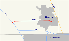
State Road 334 in the U.S. state of Indiana was a six-mile (10 km) route in southeastern Boone County.
| ||||
|---|---|---|---|---|
 | ||||
| Route information | ||||
| Maintained by INDOT | ||||
| Length | 6.26 mi[1] (10.07 km) | |||
| Existed | 1935–Summer 2011 | |||
| Major junctions | ||||
| West end | ||||
| East end | ||||
| Location | ||||
| Counties | Boone | |||
| Highway system | ||||
| ||||
Route description
State Road 334 connected Interstate 65 (at exit 130) with U.S. Route 421. Its western terminus was at Indianapolis Road just west of Interstate 65. It passed through the downtown area of Zionsville.
History
State Road 334 was decommissioned by the Indiana Department of Transportation in the summer of 2011 and turned over to local units of government. The portion within the Town of Whitestown was turned over to it and the portion within the Town of Zionsville was turned over to it. The bridges along the route were turned over to Boone County.[2][3]
Major intersections
The entire route was in Boone County.
| Location | mi[1] | km | Destinations | Notes | |
|---|---|---|---|---|---|
| Whitestown | 0.00 | 0.00 | Western terminus of SR 334; exit number 130 on I-65 | ||
| Zionsville | 6.26 | 10.07 | Eastern terminus of SR 334 | ||
| 1.000 mi = 1.609 km; 1.000 km = 0.621 mi | |||||
gollark: Exciting news: I have deanimationified the image and can now read all 98 things it says.
gollark: Did you know?
gollark: ↓ you
gollark: Consider the following.
gollark: ↓ you
References
- "INDOT Roadway Referencing System" (PDF). Archived from the original (PDF) on 2011-06-15.
- Rose, Rod (July 13, 2011). "Ind. 334 transfer to local governments complete". Zionsville Times Sentinel. Zionsville, Indiana: Timessentinel.com. Retrieved 2013-12-16.
- http://dothemod.indy.com/posts/state-gives-zionsville-control-of-5-mile-section-of-ind-334-2%5B%5D
External links
This article is issued from Wikipedia. The text is licensed under Creative Commons - Attribution - Sharealike. Additional terms may apply for the media files.
