Devil's Thumb (Greenland)
Devil's Thumb (Greenlandic: Kullorsuaq, Danish: Djœvelens Tommelfinger) is a pinnacle-shaped, 546 m (1,791 ft)[1] mountain in the Avannaata municipality in northwestern Greenland.
| Devil's Thumb | |
|---|---|
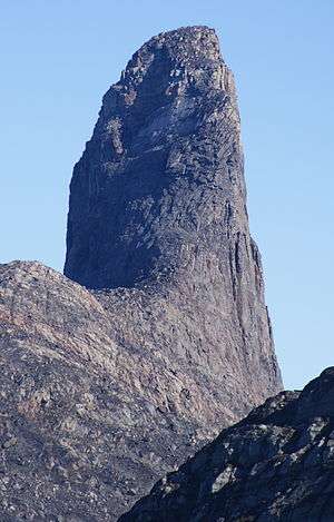 Devil's Thumb seen from the southwest | |
| Highest point | |
| Elevation | 546 m (1,791 ft) [1] |
| Prominence | 546 m (1,791 ft) |
| Coordinates | 74°35′37″N 57°08′28″W |
| Geography | |
 Devil's Thumb | |
| Location | Kullorsuaq Island, Upernavik Archipelago, Greenland |
Geography
Devil's Thumb is located in the central part of Kullorsuaq Island, an island in the northern part of Upernavik Archipelago, in Melville Bay, approximately 3 km (1.9 mi) to the north of the Kullorsuaq settlement.[1]
It is a familiar feature for Arctic navigators, similar to the Melville Monument further north, but bigger.[2]
gollark: <:chips:453465151132139521> <:chips:453465151132139521> <:chips:453465151132139521> <:chips:453465151132139521> <:chips:453465151132139521> <:chips:453465151132139521> <:chips:453465151132139521> <:chips:453465151132139521> <:chips:453465151132139521> <:chips:453465151132139521> <:chips:453465151132139521> <:chips:453465151132139521> <:chips:453465151132139521> <:chips:453465151132139521> <:chips:453465151132139521> <:chips:453465151132139521> <:chips:453465151132139521> <:chips:453465151132139521> <:chips:453465151132139521> <:chips:453465151132139521> <:chips:453465151132139521> <:chips:453465151132139521> <:chips:453465151132139521> <:chips:453465151132139521> <:chips:453465151132139521> <:chips:453465151132139521> <:chips:453465151132139521> <:chips:453465151132139521> <:chips:453465151132139521> <:chips:453465151132139521> <:chips:453465151132139521> <:chips:453465151132139521> <:chips:453465151132139521> <:chips:453465151132139521> <:chips:453465151132139521> <:chips:453465151132139521> <:chips:453465151132139521> <:chips:453465151132139521> <:chips:453465151132139521> <:chips:453465151132139521> <:chips:453465151132139521> <:chips:453465151132139521> <:chips:453465151132139521> <:chips:453465151132139521> <:chips:453465151132139521> <:chips:453465151132139521> <:chips:453465151132139521> <:chips:453465151132139521> <:chips:453465151132139521> <:chips:453465151132139521> <:chips:453465151132139521> <:chips:453465151132139521> <:chips:453465151132139521> <:chips:453465151132139521> <:chips:453465151132139521> <:chips:453465151132139521> <:chips:453465151132139521> <:chips:453465151132139521>
gollark: <:chips:453465151132139521> <:chips:453465151132139521> <:chips:453465151132139521> <:chips:453465151132139521> <:chips:453465151132139521> <:chips:453465151132139521> <:chips:453465151132139521> <:chips:453465151132139521> <:chips:453465151132139521> <:chips:453465151132139521> <:chips:453465151132139521> <:chips:453465151132139521> <:chips:453465151132139521> <:chips:453465151132139521> <:chips:453465151132139521> <:chips:453465151132139521> <:chips:453465151132139521> <:chips:453465151132139521> <:chips:453465151132139521> <:chips:453465151132139521> <:chips:453465151132139521> <:chips:453465151132139521> <:chips:453465151132139521> <:chips:453465151132139521> <:chips:453465151132139521> <:chips:453465151132139521> <:chips:453465151132139521> <:chips:453465151132139521> <:chips:453465151132139521> <:chips:453465151132139521> <:chips:453465151132139521> <:chips:453465151132139521> <:chips:453465151132139521> <:chips:453465151132139521> <:chips:453465151132139521> <:chips:453465151132139521> <:chips:453465151132139521> <:chips:453465151132139521> <:chips:453465151132139521> <:chips:453465151132139521> <:chips:453465151132139521> <:chips:453465151132139521> <:chips:453465151132139521> <:chips:453465151132139521> <:chips:453465151132139521> <:chips:453465151132139521> <:chips:453465151132139521> <:chips:453465151132139521> <:chips:453465151132139521> <:chips:453465151132139521> <:chips:453465151132139521> <:chips:453465151132139521> <:chips:453465151132139521> <:chips:453465151132139521> <:chips:453465151132139521> <:chips:453465151132139521> <:chips:453465151132139521> <:chips:453465151132139521>
gollark: <:chips:453465151132139521> <:chips:453465151132139521> <:chips:453465151132139521> <:chips:453465151132139521> <:chips:453465151132139521> <:chips:453465151132139521> <:chips:453465151132139521> <:chips:453465151132139521> <:chips:453465151132139521> <:chips:453465151132139521> <:chips:453465151132139521> <:chips:453465151132139521> <:chips:453465151132139521> <:chips:453465151132139521> <:chips:453465151132139521> <:chips:453465151132139521> <:chips:453465151132139521> <:chips:453465151132139521> <:chips:453465151132139521> <:chips:453465151132139521> <:chips:453465151132139521> <:chips:453465151132139521> <:chips:453465151132139521> <:chips:453465151132139521> <:chips:453465151132139521> <:chips:453465151132139521> <:chips:453465151132139521> <:chips:453465151132139521> <:chips:453465151132139521> <:chips:453465151132139521> <:chips:453465151132139521> <:chips:453465151132139521> <:chips:453465151132139521> <:chips:453465151132139521> <:chips:453465151132139521> <:chips:453465151132139521> <:chips:453465151132139521> <:chips:453465151132139521> <:chips:453465151132139521> <:chips:453465151132139521> <:chips:453465151132139521> <:chips:453465151132139521> <:chips:453465151132139521> <:chips:453465151132139521> <:chips:453465151132139521> <:chips:453465151132139521> <:chips:453465151132139521> <:chips:453465151132139521> <:chips:453465151132139521> <:chips:453465151132139521> <:chips:453465151132139521> <:chips:453465151132139521> <:chips:453465151132139521> <:chips:453465151132139521> <:chips:453465151132139521> <:chips:453465151132139521> <:chips:453465151132139521> <:chips:453465151132139521>
gollark: <:chips:453465151132139521> <:chips:453465151132139521> <:chips:453465151132139521> <:chips:453465151132139521> <:chips:453465151132139521> <:chips:453465151132139521> <:chips:453465151132139521> <:chips:453465151132139521> <:chips:453465151132139521> <:chips:453465151132139521> <:chips:453465151132139521> <:chips:453465151132139521> <:chips:453465151132139521> <:chips:453465151132139521> <:chips:453465151132139521> <:chips:453465151132139521> <:chips:453465151132139521> <:chips:453465151132139521> <:chips:453465151132139521> <:chips:453465151132139521> <:chips:453465151132139521> <:chips:453465151132139521> <:chips:453465151132139521> <:chips:453465151132139521> <:chips:453465151132139521> <:chips:453465151132139521> <:chips:453465151132139521> <:chips:453465151132139521> <:chips:453465151132139521> <:chips:453465151132139521> <:chips:453465151132139521> <:chips:453465151132139521> <:chips:453465151132139521> <:chips:453465151132139521> <:chips:453465151132139521> <:chips:453465151132139521> <:chips:453465151132139521> <:chips:453465151132139521> <:chips:453465151132139521> <:chips:453465151132139521> <:chips:453465151132139521> <:chips:453465151132139521> <:chips:453465151132139521> <:chips:453465151132139521> <:chips:453465151132139521> <:chips:453465151132139521> <:chips:453465151132139521> <:chips:453465151132139521> <:chips:453465151132139521> <:chips:453465151132139521> <:chips:453465151132139521> <:chips:453465151132139521> <:chips:453465151132139521> <:chips:453465151132139521> <:chips:453465151132139521> <:chips:453465151132139521> <:chips:453465151132139521> <:chips:453465151132139521>
gollark: <:chips:453465151132139521> <:chips:453465151132139521> <:chips:453465151132139521> <:chips:453465151132139521> <:chips:453465151132139521> <:chips:453465151132139521> <:chips:453465151132139521> <:chips:453465151132139521> <:chips:453465151132139521> <:chips:453465151132139521> <:chips:453465151132139521> <:chips:453465151132139521> <:chips:453465151132139521> <:chips:453465151132139521> <:chips:453465151132139521> <:chips:453465151132139521> <:chips:453465151132139521> <:chips:453465151132139521> <:chips:453465151132139521> <:chips:453465151132139521> <:chips:453465151132139521> <:chips:453465151132139521> <:chips:453465151132139521> <:chips:453465151132139521> <:chips:453465151132139521> <:chips:453465151132139521> <:chips:453465151132139521> <:chips:453465151132139521> <:chips:453465151132139521> <:chips:453465151132139521> <:chips:453465151132139521> <:chips:453465151132139521> <:chips:453465151132139521> <:chips:453465151132139521> <:chips:453465151132139521> <:chips:453465151132139521> <:chips:453465151132139521> <:chips:453465151132139521> <:chips:453465151132139521> <:chips:453465151132139521> <:chips:453465151132139521> <:chips:453465151132139521> <:chips:453465151132139521> <:chips:453465151132139521> <:chips:453465151132139521> <:chips:453465151132139521> <:chips:453465151132139521> <:chips:453465151132139521> <:chips:453465151132139521> <:chips:453465151132139521> <:chips:453465151132139521> <:chips:453465151132139521> <:chips:453465151132139521> <:chips:453465151132139521> <:chips:453465151132139521> <:chips:453465151132139521> <:chips:453465151132139521> <:chips:453465151132139521>
References
| Wikimedia Commons has media related to Devil's Thumb. |
- Upernavik Avannarleq, Saga Map, Tage Schjøtt, 1992
- Geographical Items on North Greenland Encyclopedia Arctica 14
This article is issued from Wikipedia. The text is licensed under Creative Commons - Attribution - Sharealike. Additional terms may apply for the media files.