Saarlia Island
Saarlia Island (old spelling: Sârdlia) is an uninhabited island in the Qaasuitsup municipality in northwestern Greenland.
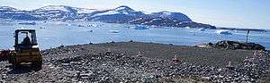 Saarlia Island and Kiatassuaq Island (behind) seen from Kullorsuaq Heliport | |
 Saarlia | |
| Geography | |
|---|---|
| Location | Greenland |
| Coordinates | 74°32′50″N 57°19′00″W |
| Archipelago | Upernavik Archipelago |
| Administration | |
Greenland | |
| Municipality | Qaasuitsup |
Geography
Part of the Upernavik Archipelago, Saarlia Island is located in the southern part of Melville Bay, approximately 3.7 km (2.3 mi) north of Kiatassuaq Island, and 2.7 km (1.7 mi) to the southwest of Kullorsuaq settlement on Kullorsuaq Island.[1] The highest point on the island is an unnamed 200 m (660 ft) hill in the center of the island.[1]
gollark: I also added a small note to https://wiki.computercraft.cc/Gps.locate about the results not always being reliable, since GPS is kind of vulnerable to spoofing.
gollark: It's more of a general guide-type thing explaining how to set up GPS hosts than information on how to use `gps host` itself.
gollark: Er, libraries.
gollark: The https://wiki.computercraft.cc/Network_security, which was admittedly mostly done by me then edited a lot by Lignum, links to some encryption APIs.
gollark: I think there's precedent.
References
| Wikimedia Commons has media related to Saarlia Island. |
- Upernavik Avannarleq, Saga Map, Tage Schjøtt, 1992
This article is issued from Wikipedia. The text is licensed under Creative Commons - Attribution - Sharealike. Additional terms may apply for the media files.