Kingittorsuaq Island
Kingittorsuaq Island (old spelling: Kingigtorssuaq) is a small, uninhabited island in the Avannaata municipality in northwestern Greenland. It is a small island in the southern part of the Upernavik Archipelago, located on the southwestern shores of Upernavik Icefjord, near the mouth of the latter where it opens into Baffin Bay.[1] The name of the island means "a large protruding rock" in the Greenlandic language.
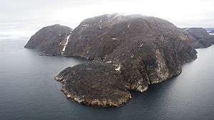 Aerial view of Kingittorsuaq Island | |
 Kingittorsuaq | |
| Geography | |
|---|---|
| Location | Greenland |
| Coordinates | 72°57′55″N 56°12′45″W |
| Archipelago | Upernavik Archipelago |
| Length | 3.7 km (2.3 mi) |
| Width | 2.7 km (1.68 mi) |
| Administration | |
Greenland | |
| Municipality | Avannaata |
History
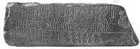
Runestone
The Kingittorsuaq runestone (old spelling: Kingigtorssuaq runestone) dating from the Middle Ages[2] was found in 1824 on the highest point of the island, in a group of three cairns forming an equilateral triangle. The stone is now located at the National Museum of Denmark in Copenhagen.
gollark: ```Redeem this coupon at participating GTech™ apionic sites for one (4) billion apioform!Expires at the death of the universe or when time ceases to meaningfully exist.Some conditions apply. Including the PotatOS privacy policy. But probably other ones.untrusted comment: signature from minisign secret keyRWTh5FGDfmGcoLjG1PmeWxltoG9zVsN499xmlB3Be+JyOX/8dXux+KErDMbEMLP1DJ6CSzR68GZqnnomUf6j6iMB3zZK65XJxQQ=trusted comment: GTech™ couponic program coupon [REDACTED]-υPNm87heTqEE5YyTASxMnsd8DsRXuERZPPc62P07mbU8AWRYkTgon0EIAKCATlbbfAijd1xRqZApRUqyxTRbBBA==```
gollark: Imagine having any idea what the compiler is doing.
gollark: You can just not do that, and it'll interop perfectly with other things.
gollark: Yes.
gollark: The Rust ones are actually token stream → token stream.
References
- Upernavik, Saga Map, Tage Schjøtt, 1992
- Enterline, James Robert (2002). Erikson, Eskimos & Columbus: Medieval European Knowledge of America. Center for American Places (illustrated ed.). JHU Press. pp. 127–129. ISBN 0-8018-6660-X. Retrieved 2010-08-26.
This article is issued from Wikipedia. The text is licensed under Creative Commons - Attribution - Sharealike. Additional terms may apply for the media files.