Cyclone Drena
Severe Tropical Cyclone Drena was a powerful tropical cyclone that caused significant damage throughout New Zealand. A tropical depression formed on January 2, 1997. After crossing Vanuatu and emerging into the Coral Sea, the storm began to intensify, and by January 6, had attained peak intensity. After attaining peak intensity, Drena began to weaken. Cyclone Drena later brushed New Caledonia, bringing some damage. After transitioning into an extratropical cyclone on January 9, Drena brought impact to New Zealand. Damage totaled to $6.7 million and 3 people were killed. Roughly 140 people were evacuated after 44 homes were flooded. After the season, Drena was retired.
| Category 4 severe tropical cyclone (Aus scale) | |
|---|---|
| Category 4 tropical cyclone (SSHWS) | |
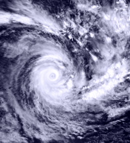
 Tropical Cyclone Drena on January 6, 1997 | |
| Formed | January 2, 1997 |
| Dissipated | January 13, 1997 |
| (Extratropical after January 9, 1997) | |
| Highest winds | 10-minute sustained: 165 km/h (105 mph) 1-minute sustained: 220 km/h (140 mph) |
| Lowest pressure | 935 hPa (mbar); 27.61 inHg |
| Fatalities | 3 total |
| Damage | $6.7 million (1997 USD) |
| Areas affected | The Solomon Islands, Vanuatu, New Caledonia, Norfolk Island and New Zealand |
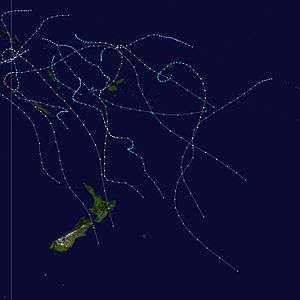
| Part of the 1996–97 South Pacific and Australian region cyclone seasons | |
Meteorological history

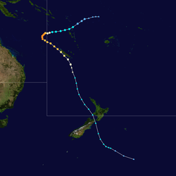
During the opening days of 1997, the precursor tropical low to Severe Tropical Cyclone Drena, developed within a monsoon trough of low pressure to the north of Fiji.[1][2] Over the next couple of days, the system moved west-southwestwards along a subtropical ridge of high pressure and gradually developed further, with a low-level inflow and an upper divergent easterly flow aiding the systems development.[3] The storm subsequently impacted northern Vanuatu during January 3, while the United States Joint Typhoon Warning Center (JTWC) initiated advisories on the system and designated it as Tropical Cyclone 16P.[2][4] Later that day, after the storm had moved into the Coral Sea the system started to rapidly intensify, as vertical wind shear decreased.[3] In response, the Fiji Meteorological Service reported that the system had become a Category 1 tropical cyclone, on the Australian tropical cyclone intensity scale and named it Drena.[nb 1][1]
After being named, Drena continued to move westwards and rapidly develop, with an eye becoming clearly defined on satellite imagery.[5] As a result of the rapid development, the system became a Category 3 severe tropical cyclone during January 4, as it moved out of the South Pacific basin and into the Australian region.[6] At around this time the system started to interact with a deep short wave trough of low pressure, which ultimately caused the system to recurve and move south-eastwards and pass through a weakness in the subtropical ridge of high pressure.[1] The JTWC subsequently estimated during the next day that Drena had peaked with 1-minute sustained wind speeds of 220 km/h (140 mph), which made it equivalent to a Category 4 hurricane on the Saffir-Simpson hurricane wind scale.[2] During January 5, the Australian Bureau of Meteorology reported that the system had peaked as a Category 4 severe tropical cyclone, with 10-minute sustained wind speeds estimated at 165 km/h (105 mph) and a central pressure of 935 hPa (27.61 inHg).[6][7]
Continuing to move south-eastwards, the storm moved back into the South Pacific basin during January 6, where it started to weaken as wind shear ahead of the trough of low pressure increased.[6][1] The system subsequently brushed the west coast of New Caledonia, as a Category 3 severe tropical cyclone between January 7–8.[6][8] As the system brushed New Caledonia, a trough of low pressure moved into the Tasman Sea, which caused north-northwesterly winds over the system to strengthen and shear the storm's upper level cloud mass towards the southeast.[7] These north-northwesterly winds also caused the system to accelerate southeastwards, towards the cooler waters surrounding Norfolk Island.[7] Drena started to transition into an extra-tropical cyclone by 06:00 on January 8, before it started to significantly weaken during that day with the systems structure becoming asymmetrical.[6][7] The system subsequently passed over Norfolk Island as a Category 2 tropical cyclone at around 06:15 UTC on January 9, before it was declared to be an extratropical cyclone by New Zealand's MetService later that day.[1][7] However, the JTWC continued issuing warnings on Drena as a tropical cyclone, until late on January 10 when they declared it to be an extratropical cyclone.[9] The system subsequently crossed New Zealand's North Island near Wanganui, before its centre reformed off the coast of Hawke's Bay during January 11.[10] It then became unclear where Drena's remnants went, but a low was observed to the east of Canterbury which moved away from the South Island slowly during January 12.[10] The systems remnants were then last noted by MetService during January 13, while they were located around 1,500 km (930 mi) to the southeast of Wellington, New Zealand.[6]
Preparations and impact
While it was active Drena impacted the Solomon Islands, Vanuatu, New Caledonia, Norfolk Island and New Zealand, some of which had been affected by a few days earlier.[1] As a result of the impact caused by the system the name Drena was retired after the season had ended, by the World Meteorological Organization's RA V Tropical Cyclone Committee.[11]
Between January 3 – 6, Vanuatu and the Solomon Islands, became the first two island nations to be impacted by Drena, less than two weeks after Severe Tropical Cyclone Fergus had affected the islands.[6][12] Strong winds, heavy rain and high seas impacted both island nations, with extensive damage reported on the coral limestone atoll of Rennell Island.[1][13] The system was subsequently expected to impact the coast of Queensland later that week, before it recurved and impacted New Caledonia between January 7–8.[8][14]
Ahead of Drena impacting New Caledonia, the French territory was placed on maximum alert, with residents told to stay indoors during the cyclone.[15] The system subsequently moved down and impacted most of New Caledonia's West Coast between January 7–8, but spared the capital: Nouméa any major damage. Heavy rains accompanied the storm, peaking at 474 mm (18.7 in) in Dzumac. La Foa also recorded 202 mm (8.0 in) of rain. Wind gusts reached 165 km/h (105 mph) in Koumac.[16] Almost all crops were destroyed and many roads were flooded.[17] High winds knocked out power and communication to most of the island.[16][18]
After Drena had impacted New Caledonia it moved south-eastwards and passed over Norfolk Island, while transitioning into an extra-tropical cyclone.
Severe Tropical Cyclone Drena was responsible for damaged roads, property, and agriculture to New Zealand.[19] Overall, damage totaled to $6.7 million (1996 USD). Insurance payouts totaled to $3.2 million. Meanwhile, damage to roads totaled to $2 million and over $1.5 million was down to property.[20] A total of 3 deaths were reported.[20] One man was electrocuted during the storm when he grabbed a fallen powerline when he was climbing up a bank.[21] In addition, An elderly couple died when their car slid sideways into another car on a road.[20] High waves from Cyclone Drena crashed against sea walls along the northern coast of New Zealand.[19]
Roughly 140 people were evacuated at Moanatairi while residents from 20 homes were evacuated at Moanatairi, Te Puru, and Waiomu. A total of 44 homes were flooded and subsequently damaged; 33 of which had soaked carpets and ruined walls and furniture. Considerable damage was recorded on North Island, trees and powerlines were downed and house roofs were lifted. Severe damage was reported in a Northland camp ground. One road was closed for 30 hours. In Auckland City, widespread damage and flooding was reported. Offshore, ferries were cancelled. In Maramarua, around 30 customers were without power for several hours. Several trams were flooded in Waikawau. Several rives were flooded in the Southland. Throughout the island, widespread rains and flooding was reported. In addition. Hauraki Gulf measured winds of up to 160 km/h (99 mph). In Thames, 3.6 m (12 ft) swells were measured. Christchurch received 47 mm (1.9 in) of rain.[20]
New Zealand
Between January 10–12, Drena became the second system to impact New Zealand, about two weeks after the remnants of Severe Tropical Cyclone Fergus had affected the island nation.[10] Ahead of the system impacting New Zealand, MetService warned that heavy rain and severe gales were expected in several northern districts, while issuing various warnings for the island nation.[10]
Notes
- Severe Tropical Cyclone Drena was officially monitored by three warning centres during its lifetime. These were the Fiji Meteorological Service, MetService and the Australian Bureau of Meteorology.
See also
- Cyclone Bola
- Cyclone Wilma (2011)
References
- Hanstrum, B N; Bate P W. "The South Pacific and Southeast Indian Ocean Tropical Cyclone Season 1996–97" (PDF). Australian Meteorological Magazine. Australian Bureau of Meteorology. 48: 121–138. Retrieved May 29, 2011.
- "JTWC best track analysis: Tropical Cyclone 16P (Drena)". United States Joint Typhoon Warning Center. Archived from the original on May 25, 2015.
- Darwin Tropical Diagnostic Statement: January 1997 (PDF) (Report). 16. Australian Bureau of Meteorology. 1997. pp. 2–3. ISSN 1321-4233. Archived (PDF) from the original on September 14, 2015. Retrieved January 2, 2017.
- "Tropical Cyclone Warning 1 January 3, 1997 03z". United States Joint Typhoon Warning Center. January 3, 1997. Archived from the original on June 5, 2015. Retrieved January 2, 2017.
- "Tropical Cyclone Warning 4 January 4, 1997 15z". United States Joint Typhoon Warning Center. January 4, 1997. Archived from the original on June 5, 2015. Retrieved January 2, 2017.
- MetService (May 22, 2009). "TCWC Wellington Best Track Data 1967–2006". International Best Track Archive for Climate Stewardship.
- Buckley, B. W.; Leslie, L. M. (1998). "High resolution numerical simulation of Tropical Cyclone Drena undergoing extra-tropical transition". Meteorology and Atmospheric Physics. 65 (3–4): 207–222. Bibcode:1998MAP....65..207B. doi:10.1007/BF01030789.
- "Cyclone Passes De 1880 à nos jours" (in French). Meteo France New Caledonia. Retrieved January 2, 2017.
- "Tropical Cyclone Warning 16 January 10, 1997 15z". United States Joint Typhoon Warning Center. January 10, 1997. Archived from the original on June 5, 2015. Retrieved January 2, 2017.
- "Cyclone Drena January 10-12, 1997". MetService. November 11, 2004. Archived from the original on January 7, 2017. Retrieved January 7, 2017.
- RA V Tropical Cyclone Committee (October 11, 2018). Tropical Cyclone Operational Plan for the South-East Indian Ocean and the Southern Pacific Ocean 2018 (PDF) (Report). World Meteorological Organization. pp. I-4–II-9 (9–21). Archived from the original on October 12, 2018. Retrieved October 12, 2018.
- "Tropical Cyclones/Depressions that passed through Solomon Islands Region" (PDF). Solomon Islands Meteorological Service. September 13, 2009. Archived from the original (PDF) on March 9, 2013. Retrieved January 7, 2017.
- "Solomon Islanders ordered to higher ground in face of cyclone". Agence France Presse. January 5, 1997. – via Lexis Nexis (subscription required)
- "Fergus blows away town's rain records". Waikato Times. January 7, 1997. p. 3. – via Lexis Nexis (subscription required)
- "Telephones and electricity cut as cyclone nears New Caledonia". Agence France Presse. January 7, 1997. – via Lexis Nexis (subscription required)
- "Phénomènes tropicaux ayant le plus durement touché la Nouvelle-Calédonie depuis la fin du XIXe siècle" (in French). Meteo-France. 2009. Archived from the original on July 14, 2009. Retrieved August 5, 2009.
- (in French) New Caledonia Meteorological Office (2011). Cyclone Passes Entre 1950 et 1995: Beni 2003 (Report). Météo-France. Archived from the original on June 26, 2011. Retrieved August 21, 2012.
- "Earthweek: A Diary of the Planet". Pittsburgh Post-Gazette. January 13, 1997. Retrieved August 5, 2009.
- Kanchan Ratna Chopra (2005). Ecosystems and Human Well-Being: Policy responses : Finding of responses. Millennium Ecosystem Assessment.
- "January 1997 New Zealand Ex-tropical Cyclone Drena ( 1997-01-10 )". NZ Historic Weather Events Catalog. Retrieved November 2, 2011.
- "Storms and Cyclones". NIWA. Retrieved November 2, 2012.
External links
- World Meteorological Organization
- Australian Bureau of Meteorology
- Fiji Meteorological Service
- New Zealand MetService
- Joint Typhoon Warning Center
