Alabang–Zapote Road
Alabang–Zapote Road is a four-lane national road which travels east–west through the southern limits of Metro Manila, Philippines. It runs parallel to Dr. Santos Avenue in the north and is named for the two barangays that it links: Alabang in Muntinlupa and Zapote in Las Piñas.
| ||||
|---|---|---|---|---|
| Calle Real Real Street Zapote–Alabang Road | ||||
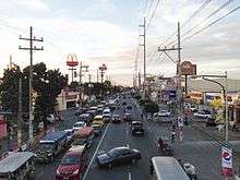
 Alabang–Zapote Road past University of Perpetual Help System DALTA | ||||
| Route information | ||||
| Maintained by Department of Public Works and Highways and Metropolitan Manila Development Authority | ||||
| Length | 10.9 km (6.8 mi) | |||
| Component highways | ||||
| Major junctions | ||||
| West end | ||||
| ||||
| East end | ||||
| Location | ||||
| Provinces | Metro Manila, Cavite | |||
| Major cities | Muntinlupa, Las Piñas, Bacoor | |||
| Highway system | ||||
| ||||
.svg.png)
From its eastern terminus at an interchange with South Luzon Expressway, Manila South Road, and Montillano Street, the road runs westwards for 10.2 kilometers (6.3 mi) to the junction with Diego Cera Avenue and Aguinaldo Highway. Since 1997, it also extends further west for several hundred meters connecting Las Piñas to its present terminus at Coastal Road (R-1) in Bacoor, Cavite.[1]
The road carries more than 70,000 vehicles per day as of 2016, and suffers from traffic jams. The Metropolitan Manila Development Authority (MMDA) listed Alabang-Zapote Road as a major traffic bottleneck point or choke point, and the Unified Vehicular Volume Reduction Program (UVVRP), or "color coding" scheme, is modified for the road to no longer include window hours.
The entire route is designated as National Route 411 (N411) of the Philippine highway network.[2]
History
Alabang–Zapote Road follows an old Spanish coastal trail that linked the Province of Manila to La Laguna and other southern provinces. It was called Calle Real (Spanish for "royal street") or Camino Real (Spanish for "royal way") which spanned from Ermita to Muntinlupa.[3] At present, only the Las Piñas-to-Muntinlupa section is called Calle Real or Real Street as an alternative name for the road. The rest of the route had been renamed to Del Pilar Street in the City of Manila, Harrison Avenue in Pasay, Elpidio Quirino Avenue in Parañaque, and Diego Cera Avenue in Las Piñas (Manuyo Uno–Zapote segment).
Route description
The road begins at the junction of Manila South Road, Montillano Street, and South Luzon Expressway's Alabang Exit in Alabang, Muntinlupa, near Starmall Alabang. It then crosses into Filinvest City and Barangays Cupang and Ayala Alabang, where Alabang Town Center and the Madrigal Business Park are located, intersecting with Madrigal Avenue and Acacia Avenue. West of Daang Hari Road (Investment Drive), it then enters Las Piñas and Barangays Almanza Dos and Almanza Uno, where SM Southmall is located. From Marcos Alvarez Avenue to CAA Avenue-BF Resort Drive, the road traverses Barangays Talon Uno, Talon Dos, Talon Tres, and Talon Cuatro. It then traverses Barangays Pamplona Tres, Pamplona Dos, and Pamplona Uno as it goes past the Las Piñas City Hall, SM Center Las Piñas, and Starmall Las Piñas. A flyover and bridge was built in 1997 to connect Zapote, Las Piñas with Zapote, Bacoor (Longos) over the Zapote River where the road ends at an interchange with Coastal Road (CAVITEX). Electric power subtransmission lines by Meralco, placed on tall roadside posts, also shared by distribution lines, line almost the whole length of the road from Zapote in Las Piñas to Alabang in Muntinlupa and the proposed Las Piñas–Muntinlupa Expressway, which is worth ₱2.75 billion.
Traffic
As of July 2016, the Las Piñas Traffic Management Office reported more than 70,000 vehicles travelling on Alabang-Zapote Road daily, that already reached above its allowable capacity.[4] The road gained notoriety for its traffic jams, and it is listed by the Metro Manila Development Authority as a major traffic bottleneck area in south Metro Manila, along with other major roads leading to Ninoy Aquino International Airport, like Sucat Road, Andrews Avenue, and Domestic Road.[5] The Unified Vehicular Volume Reduction Program (UVVRP), or the "coding" scheme, is modified for Alabang-Zapote Road to have no "window hours".[6]
Intersections
Intersections in the list below are arranged by kilometer number, based on numbers on kilometer stones from Rizal Park in Manila, the Kilometer Zero.
Mainline
| Province | City/Municipality | km[7] | mi | Destinations | Notes |
|---|---|---|---|---|---|
| Cavite | Bacoor | Western terminus. Access to Bacoor (Longos) Exit of CAVITEX. No left turn allowed from Alabang–Zapote Road. | |||
| Las Piñas-Talaba Diversion Road | No access from opposite direction | ||||
| West end of Zapote Flyover | |||||
| Zapote River | Zapote Bridge 2 | ||||
| Las Piñas | 14.773 | 9.180 | Western terminus. Access to Las Piñas Bamboo Organ Church. | ||
| 15.000 | 9.321 | East end of Zapote Flyover | |||
| Fruto Santos Avenue (Tramo Street) | |||||
| 16.400 | 10.190 | Doña Manuela Avenue | |||
| 16.800 | 10.439 | C.V. Starr Avenue | Serves Starmall Las Piñas and BF Resort | ||
| 17.500 | 10.874 | Manila Times Street / Aria Street | Serves University of Perpetual Help System DALTA - Las Piñas | ||
| 18.670 | 11.601 | CAA Road / BF Resort Avenue | Serves BF Resort | ||
| 20.073 | 12.473 | Marcos Alvarez Avenue | |||
| 22.100 | 13.732 | Concha Cruz Drive | Serves BF Homes | ||
| Muntinlupa | 22.386 | 13.910 | Investment Drive – Daang Hari, San Pedro | ||
| 22.550 | 14.012 | Acacia Avenue | Serves Madrigal Business Park and Ayala Alabang Village | ||
| 22.714 | 14.114 | Don Manolo Drive | Serves Alabang Hills and San Beda College Alabang | ||
| 23.048 | 14.321 | Madrigal Avenue | Serves Alabang Town Center and Ayala Alabang Village | ||
| 24.023 | 14.927 | Filinvest Avenue | Left turns allowed from Skyway only | ||
| Skyway | Entrance and exit | ||||
| North Bridgeway | Serves Northgate Cyberzone | ||||
| 24.381 | 15.150 | North Bridgeway / Spectrum Midway | Serves Vivere Hotel Alabang and Festival Alabang | ||
| 24.707 | 15.352 | Corporate Avenue | Serves South Station, Filinvest Corporate City, Crimson Hotel and Festival Alabang | ||
| 24.956 | 15.507 | No left turns | |||
| 25.099 | 15.596 | Eastern terminus. Access from Manila South Road only. | |||
| 1.000 mi = 1.609 km; 1.000 km = 0.621 mi | |||||
Spur
The entire route is located in Muntinlupa. This 258-meter (846 ft) segment[2] in Alabang has no official kilometer count.
| km | mi | Destinations | Notes | ||
|---|---|---|---|---|---|
| Western terminus. Connection with main route. No left turns from the westbound lane of Alabang–Zapote Road mainline. | |||||
| Eastern terminus. Access to Manila South Road northbound is closed; accessible via U-turn slot beneath Alabang Viaduct. | |||||
| 1.000 mi = 1.609 km; 1.000 km = 0.621 mi | |||||
Landmarks


Many commercial establishment, like malls and major commercial areas, and other major landmarks are found on or near the vicinity of Alabang-Zapote Road. Malls, like South Station and Festival Alabang by Filinvest, Alabang Town Center by Ayala Malls, SM Southmall and SM Center Las Piñas by SM Supermalls, Robinsons Place Las Pinas by Robinsons Malls, and Uniwide Metromall by the defunct Uniwide Sales, Inc., are found beside or accessible via Alabang-Zapote Road. Major commercial areas and developments, like Madrigal Business Park, Molito, Westgate Alabang, Northgate Cyberzone, and Filinvest City, are also accessed through the road. The city hall of Las Piñas is found along Alabang-Zapote Road. Major hotels that lie on or near the vicinity of the road includes Crimson Hotel and Vivere Hotel in Muntinlupa, and Eurotel and Dream Hotel in Las Piñas.
References
- Flyover construction rushed for Christmas published by Manila Standard; accessed October 17, 2013.
- "Road and Bridge Inventory". www.dpwh.gov.ph. Retrieved July 6, 2020.
- Rebirth of Taft Avenue published by the Manila Bulletin; accessed October 17, 2013.
- "Las Piñas LGU on traffic problem: moratorium on franchise issuance, Task Force Ayos Trapiko". Government of the Republic of the Philippines. Philippine Information Agency. July 18, 2016. Archived from the original on January 24, 2017. Retrieved May 17, 2017.
- Frialde, Mike (July 7, 2016). "Traffic choke points in Metro Manila identified". The Philippine Star. Philstar. Retrieved May 17, 2017.
- Ramirez, Robertzon (October 18, 2016). "18 roads added to coding scheme". The Philippine Star. Philstar. Retrieved May 17, 2017.
- Some distances from 2016 DPWH Atlas road data for Las Piñas-Muntinlupa District Engineering Office. Most distances are approximates.
| Wikimedia Commons has media related to Alabang-Zapote Road. |
| Expressways |
| ||||||||
|---|---|---|---|---|---|---|---|---|---|
| National roads |
| ||||||||
| Arterial Routes |
| ||||||||