Arnaiz Avenue
Antonio S. Arnaiz Avenue, also known simply as Arnaiz Avenue and by its former names Libertad Street and Pasay Road, is a major east-west collector road that links Makati and Pasay in the Philippines. It stretches across western Metro Manila from Roxas Boulevard in the Santa Clara district of Pasay to Epifanio de los Santos Avenue (EDSA) in San Lorenzo Village in Makati.
| Libertad Street Pasay Road | |
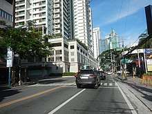
 Arnaiz Avenue east of Amorsolo Street in the Makati CBD | |
| Namesake | Antonio Arnaiz |
|---|---|
| Maintained by | Department of Public Works and Highways[1][2] |
| Length | 4.039 km[3] (2.510 mi) |
| Location | Makati and Pasay |
| West end | Roxas Boulevard in Pasay |
| Major junctions | Harrison Avenue Leveriza Street Taft Avenue Osmeña Highway (SLEX) Chino Roces Avenue Paseo de Roxas Makati Avenue |
| East end | Epifanio de los Santos Avenue in Makati |
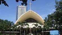
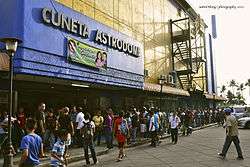
South Luzon Expressway (Osmeña Highway) splits Arnaiz Avenue into two sections. The western section found in Pasay is a congested and highly pedestrianized road that used to be known as Calle Libertad.[4] This section passes through some of the most important Pasay landmarks such as the Cuneta Astrodome, Cartimar shopping district and Santa Clara de Montefalco Church. Also located within the vicinity are the Department of Foreign Affairs building, old Pasay City Hall, Pasay City Sports Complex and Pasay Cemetery. East of Osmeña Highway, the avenue enters the Makati Central Business District where it merges with traffic from a Manila Skyway ramp near the Amorsolo Street junction. It continues across Legaspi and San Lorenzo villages of the Makati CBD which contains several office towers and condominiums such as Cityland Pasong Tamo Tower and Avida Towers, a number of Japanese restaurants, a Waltermart mall, the old Plaza Fair, Don Bosco and the Ayala Center. This section of the road in Makati used to be known as Pasay Road. Its eastern terminus is at its junction with EDSA near Dusit Thani hotel.
The avenue was named after the Filipino aviation pioneer, Antonio Somoza Arnaiz.[5] The western section is served by the LRT-1 Libertad Station along Taft Avenue, while the eastern section is served by the Pasay Road railway station along Osmeña Highway, and the Ayala MRT Station along EDSA. A small portion (1.6 km) of a continuation of the road in Dasmariñas Village, Makati is also called Arnaiz Avenue from EDSA to Tamarind Road.
Route description
The avenue is divided into two portions, one used to be named Libertad Street and the other was named Pasay Road
Libertad Street

Arnaiz Avenue starts at an intersection with Roxas Boulevard northbound near Cuneta Astrodome.[6] It then crosses F.B. Harrison Street and then crosses Taft Avenue near the Pasay Public Market and Mall and the LRT-1 Libertad Station. At this portion, the road is heavily pedestrianized and traffic queues are mostly common. It then crosses P. Zamora/P. Burgos near St. Mary's Academy - Pasay and Tramo Street and crosses Estero de Tripa de Gallina (Tripa de Gallina Creek) at a bridge on the Pasay-Makati boundary.[7] It soon ends at a traffic light intersection with Osmeña Highway near PNR Pasay Road station.
Pasay Road
After crossing Osmeña Highway, it is an east-to-west one-way street east of the PNR Pasay Road Station until it crosses Chino Roces Avenue near Waltermart Makati. The Skyway exit to Amorsolo Street stands above the avenue until it curves downward toward Amorsolo Street. Past Amorsolo Street, it crosses Paseo de Roxas near Greenbelt and Makati Avenue near Glorietta until it ends at a traffic light intersection with EDSA.[8] The avenue is lined with hotels, namely New World Makati, Fairmont Makati, and Crown Regency between Paseo de Roxas and EDSA.[9]
Intersections
Intersections are numbered by kilometer post, with Rizal Park in Manila designated as kilometer zero.
| Province | City/Municipality | km[1][2][3] | mi | Destinations | Notes |
|---|---|---|---|---|---|
| Pasay | 4.191 | 2.604 | Western terminus | ||
| Harrison Avenue | Traffic light intersection | ||||
| Leveriza Street | One-way entry to Arnaiz Avenue | ||||
| Park Avenue | |||||
| P. Villanueva Street | |||||
| Taft Avenue | Traffic light intersection | ||||
| M. Colayco Street / Decena Street | |||||
| 6.072 | 3.773 | P. Zamora Street / P. Burgos Street | Traffic light intersection; one-way street northbound | ||
| Cementina Street | One-way exit | ||||
| 7 | 4.3 | Tramo Street | |||
| Pasay – Makati boundary | 7.998 | 4.970 | Gementina Dolores Bridge | ||
| Makati | 6.133 | 3.811 | Marconi Street | Western terminus | |
| Edison Street | |||||
| Batangas Street | |||||
| Capt. M. Reyes Street | One-way exit | ||||
| Evangelista Street | One-way entrance | ||||
| Traffic light intersection; no entry to Arnaiz Avenue eastbound | |||||
| Medina Street / Estacion Street | Access to Pasay Road station | ||||
| Chino Roces Avenue | |||||
| Westbound exit only | |||||
| Amorsolo Street | Traffic light intersection | ||||
| Paseo de Roxas / Edades Street | Traffic light intersection | ||||
| Makati Avenue / San Lorenzo Drive | Traffic light intersection | ||||
| 8.099 | 5.032 | Eastern terminus; continues east into Dasmariñas Village as Pasay Road | |||
| 1.000 mi = 1.609 km; 1.000 km = 0.621 mi | |||||
Landmarks
- Asian Institute of Maritime Studies
- Cuneta Astrodome
- Cityland Pasong Tamo Tower
- Department of Foreign Affairs
- Don Bosco Technical Institute, Makati
- Dusit Thani Manila
- El Cielito Inn
- Eurotel Makati
- Fairmont Makati Hotel
- Glorietta
- Greenbelt
- Holiday Plaza
- Hotel Celeste
- Hotel Crown Regency
- Jinjiang Inn
- Light of the World Christian Academy of Makati
- Metro Business College – Arnaiz Campus
- New World Makati Hotel
- Pasay City Cockpit
- Pasay City Fire Station
- Pio del Pilar Elementary School
- Plaza Fair Makati
- Raffles Hotel Manila
- St. John Bosco Church
- St. Mary's Academy – Pasay
- San Ildefonso Church
- Santa Clara de Montefalco Church
- SM Makati
- The Beacon – Arnaiz Tower
- The Columns Legazpi Tower
- The Residences at Greenbelt
- Victory Pasay Mall
- WalterMart Makati
- Wellcome Plaza
References
- "South Manila". DPWH Road Atlas. Department of Public Works and Highways. Archived from the original on February 2, 2017. Retrieved January 24, 2017.
- "Metro Manila 2nd". DPWH Road Atlas. Department of Public Works and Highways. Archived from the original on February 2, 2017. Retrieved January 24, 2017.
- "Road and Bridge Inventory". Department of Public Works and Highways. Retrieved August 6, 2020.
- Roads and Transport published by Pasay City Government; accessed 2013-10-10.
- About Antonio Somoza Arnaiz published by Geni.com; accessed 2013-10-10.
- Google. "Arnaiz Avenue between Roxas Boulevard and Taft Avenue" (Map). Google Maps. Google.
- Google (13 December 2015). "Arnaiz Avenue between Taft Avenue and Pasay-Makati boundary" (Map). Google Maps. Google. Retrieved 13 December 2015.
- Google (13 December 2015). "Arnaiz Avenue between Osmena Highway and EDSA" (Map). Google Maps. Google. Retrieved 13 December 2015.
- "Arnaiz Avenue betwwn Paseo de Roxas and EDSA". Google Maps. Google. Retrieved 13 December 2015.
| Towers |
|  | ||||
|---|---|---|---|---|---|---|
| Ayala Center | ||||||
| Other landmarks | ||||||
| Education | ||||||
| Transportation |
| |||||
Italics denote buildings under construction or planned. | ||||||