Skyway (Metro Manila)
The Skyway, officially the Metro Manila Skyway System or Metro Manila Skyway, is an elevated highway serving as the main expressway in southern Metro Manila, Philippines, following much of the existing South Luzon Expressway's alignment by going above it. It stretches from Gil Puyat Avenue in the north to Alabang–Zapote Road in the south and crosses through the highly urbanized areas of Makati, Pasay, Taguig, Parañaque, and Muntinlupa, relieving SLEx and other major thoroughfares from heavy traffic.
| |
|---|---|
| Metro Manila Skyway System | |
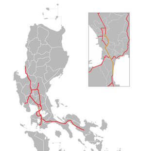 Map of expressways in Luzon, with Skyway in orange | |
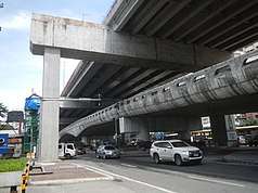
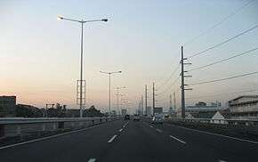 The Metro Manila Skyway facing northbound towards Osmeña Highway (March 2007) | |
| Route information | |
| Maintained by Skyway Operations and Maintenance Corporation and Citra Metro Manila Tollways Corporation | |
| Length | 40.84 km (25.38 mi) |
| Existed | 1999–present |
| Component highways | |
| Restrictions | |
| Major junctions | |
| From |
|
| |
| To | |
| Future | |
| North end | |
| South end | |
| Location | |
| Major cities | Caloocan, Quezon City, San Juan, Manila, Makati, Pasay, Taguig, Parañaque, Muntinlupa |
| Highway system | |
| |
_sign.svg.png)
The expressway is the first fully grade-separated highway in the Philippines. It will be one of the longest flyovers in the world with a total length of 40.84 kilometers (25.38 mi) when Stage 3 and the Extension Project in Muntinlupa are completed. It provides access to Ninoy Aquino International Airport via NAIA Expressway. With the completion of the Skyway Stage 3 scheduled in 2020, the elevated expressway will connect to the North Luzon Expressway in Caloocan and help cut the travel time between Metro Manila and Clark International Airport in Pampanga.[4]
With the opening of the Skyway system, traffic at the South Luzon Expressway considerably improved with the additional roadway capacity, rehabilitated roads, and upgraded and newly constructed facilities.
Route description
From the north, the Skyway originally begins in Makati, just south of Gil Puyat Avenue (Buendia Avenue). It rises above the Magallanes Interchange and returns to its original level after crossing EDSA. Past its interchange with the NAIA Expressway, it descends into ground level because of height restrictions on structures near Ninoy Aquino International Airport, paralleling SLEX and the PNR Metro South Commuter Line along the Pasay–Taguig boundary. The Skyway elevates again past the C-5 Exit and Arca South. From Bicutan, at the start of the Stage 2 segment, it continuously runs above SLEX. At the Sucat Exit, the Skyway rises above the eastern end of Dr. Santos Avenue and descends before approaching the Alabang toll plaza in Cupang, Muntinlupa. An exit leads down to the South Luzon Expressway and an entrance ramp carries traffic vice versa. Past the toll plaza and the exit to SLEX, the Skyway narrows into one lane per direction, and curves westward before joining Alabang–Zapote Road near South Station in Alabang.
Stage 3, presently under construction, is divided into five sections. Section 1 begins at the Buendia Exit and runs northwards along Osmeña Highway, veers right to Quirino Avenue (C-2) and ends at Tomas Claudio Street. Section 2 then veers right again through the private San Miguel Yamamura Packaging Corporation plant (owned by the same Skyway concessionaire San Miguel Corporation) in Pandacan, Manila, follows the curve of the San Juan River and connects to Gregorio Araneta Avenue near Santa Mesa, Manila. Past the Aurora Boulevard intersection, Section 3 moves further northwards along Araneta until it reaches Quezon Avenue, where Section 4 continues, veers left to Sgt. Rivera Avenue, turns right at A. Bonifacio Avenue towards the Balintawak Interchange at EDSA. Section 5 starts from there, crosses over EDSA and Quirino Highway, and finally connects to NLEX, ending near the Balintawak Toll Plaza.[5] Stage 3 will have a total length of 18.68 kilometers (11.61 mi).[2]
History
In November 1995, the Jakarta-based investor Citra Lamtoro Gung Persada (CITRA) entered into a Supplemental Toll Operation Agreement (STOA) with the Republic of the Philippines through the Toll Regulatory Board (TRB) as grantor, and the Philippine National Construction Corporation (PNCC) as operator. It was the result of negotiations that began on October 31, 1994 with the organization of the Technical Working Group composed of representatives from the Board of Investments (BOI), the Department of Finance (DOF), AIA Capital as financial adviser, the Department of Public Works and Highways (DPWH), the TRB, the PNCC, and the PT CITRA Group. Under the STOA, Citra Metro Manila Tollways Corporation (CMMTC as the concessionaire was formally established), was mandated to finance, design, and construct stage 1 of the South Metro Manila Tollway Project, consisting of an elevated expressway from Bicutan to Buendia and the rehabilitation of the at-grade portion of the South Metro Manila Tollway project. The STOA was approved by Philippine President Fidel V. Ramos in April 1996.
Stage 1
Stage 1 involved the rehabilitation of the 13.43-kilometer (8.35 mi) at-grade portion of SLEX from Magallanes to Alabang and the construction of a 6-lane, 9.3-kilometer (5.8 mi) elevated expressway above it, from Buendia to Bicutan. Stage 1 started on April 7, 1995 and partially opened to motorists in October 1999. Buendia, Makati (now Amorsolo), Magallanes, Skyway Toll Plazas A and B, and Bicutan Exits were first to be completed in December 1997. The Don Bosco Exit was completed in January 2002, while the NAIA Terminal 3 interchange was in construction between 2004 and 2010. CMMTC spent $32.7 million on Stage 1 with a length of 9.3 kilometers (5.8 mi).[1]
Stage 2
On April 2, 2009, Citra announced the construction on the second stage.[6] By June 2009, new pillars were going up. By May 2010, Stage 2 was 50% done, rotating the highest pierhead in the Sucat area; by July it was 65% done, concreting 134 of the required 238 spans, and started pouring the asphalt overlay. On December 15, 2010, the Bicutan–Sucat portion of Stage 2 opened to the public. Motorists could use this portion for free before the Skyway reverted its toll rates back to its 2007 levels a week later. In April 2011, the Hillsborough Exit, the Alabang Toll Plaza, and the South Station Exit were opened to the public toll-free until April 25. Stage 2 extended the toll road by about 6.86 kilometers (4.26 mi) from Bicutan to Alabang.[1]
Operation and maintenance
The rehabilitated at-grade portion of the South Luzon Expressway from Nichols to Alabang and the Metro Manila Skyway System are both operated by the Skyway Operations and Maintenance Corporation (SOMCo), a company of the existing PNCC concession holder, and Citra Metro Manila Tollways Corporation. SOMCo took over the operations and maintenance of the Skyway from the former operator, PNCC Skyway Corporation, effective January 2008 and was established in compliance with the provisions stipulated in the July 2007 Amended Supplemental Toll Operators Agreement (A-STOA) between the PNCC, Citra Metro Manila Tollways Corporation, and the Toll Regulatory Board (TRB), which awarded the management of the 35-kilometer toll road to Citra. Skyway used the using Vendeka toll collection system. SOMCo is in charge of the three major operational functions of the Skyway: traffic safety and management, maintenance, and toll collection.
Technical specifications
- Name: Metro Manila Skyway
- Concession Holder: Citra Metro Manila Tollways Corporation
- Operator: Skyway Operations and Maintenance Corporation (SOMCo.)
- Length: 40.84 kilometers (25.38 miles) (including Stage 3 and Extension Project)
- Concession starting date: August 24, 1995
- Concession ending date: 2010
- Highway exits: 22 (12 operational, 10 under construction)
- Lanes: 6 lanes (3 in each direction) from Plaza Dilao to Sucat; 5 lanes (2 southbound lanes and 3 northbound lanes) of Extension Project; 4 lanes (2 in each direction) from Sucat to Hillsborough; 2 lanes (1 in each direction) from Hillsborough to Alabang-Zapote
- Exit ramps: 3
- Toll plazas: 6 (2 operational, 4 under construction or proposed)
- Height: 11 meters or 36 feet (Bicutan to Sucat, Buendia to Don Bosco, Amorsolo, and Hillsborough to Alabang), 43 meters or 141 feet (Runway Toll Plaza to Bicutan and Don Bosco to NAIA), normal (Runway Toll Plaza), 19 meters or 62 feet (Bicutan Exit and Sucat Exit)
Future
Stage 3
Dubbed as "Skyway Stage 3", the Department of Public Works and Highways (DPWH) had received an unsolicited proposal for the construction of the elevated toll road Skyway's extension from San Miguel Corporation-backed Citra Metro Manila Tollways Corp. (CMMTC) which according to their proposal would run from Bicutan, Taguig to Balintawak, Quezon City. The DPWH included the project in its PPP thrust and subjected the proposal to a Swiss Challenge, a procedure that requires a government agency which has received an unsolicited bid for a project to publish the bid and invite third parties to match or exceed it.
Construction of Skyway Stage 3 started on February 17, 2014.[7][8] However, construction delays and right-of-way issues has rescheduled its target completion date to 2020.[9]
The original plans called for the 14 km (8.7 mi) project to be divided into four segments.[10] The original alignment would consist of Zamora flyover, crossing the Pasig River, meeting up with the NLEX-SLEX Connector near the PUP campus, and passing through Old Santa Mesa Road and V. Mapa Street. However, due to right-of-way issues, the alignment was forced to be realigned, veering right from Tomas Claudio Street through the San Miguel Yamamura Packaging Corporation plastic plant in Pandacan, and follow the San Juan River up to Gregorio Araneta Avenue. A second modification of the plans added a fifth segment at the north end of the project. Instead of ending at the Balintawak Cloverleaf at EDSA, Segment 5 would cross over EDSA and Quirino Highway's Camachile and Old Novaliches Flyovers and ultimately connect to the Balintawak Toll Plaza of North Luzon Expressway in Caloocan, bringing the entire Stage 3 segment to 18.68 kilometers (11.61 mi) long.[2] This new segment opens a new possibility of further expansion to the north.
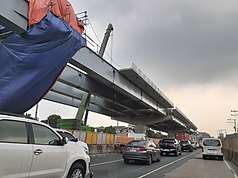
A short stretch of the northbound lanes of the Buendia–Quirino portion which crosses Buendia Avenue was opened to motorists in June 2018.[11] The Buendia–Plaza Dilao segment was then partially opened on July 22, 2019, toll-free and exclusively to Class 1 vehicles only.[12][13] A fire at the San Miguel Yamamura Packaging Corporation plastic plant in Pandacan caused a 300 m (980 ft) portion of Skyway Stage 3 to collapse, causing untimely delays in the project.[14] The damaged portions from the fire required total reconstruction of the pierheads and the replacement of the burnt girders, pushing back the opening of the segment to November 2020.[15]
Metro Pacific Tollways proposal: NLEX-SLEX Connector Road
Meanwhile, a year before the CMMTC proposal was unveiled, NLEX concessionaire Metro Pacific Tollways through its subsidiary, the NLEX Corporation (then the Manila North Tollways Corporation or MNTC) submitted its proposal dubbed "Segment 11" of its NLEX Phase 2 project. The "NLEX Connector Road (formerly NLEX-SLEX Connector Road)" would involve the construction of a 13.24-kilometer (8.23 mi) elevated expressway from Buendia (Skyway Stage 1) to the C-3 Road, which would connect to Segment 10 above existing Philippine National Railways (PNR) right-of-way.
In recommending approval for both proposals, DPWH Secretary Rogelio Singson said they could co-exist as the projects service two different corridors of the metro.[16]
Skyway Expansion Project
The project was first proposed by San Miguel Corporation in November 2017.[17] SMC envisions its project expanding the two-lane section from Hillsborough toll plaza to Alabang to six (three lanes each way), and building a 6-kilometer (3.7 mi) extension from South Station Alabang, the current southern terminus, to SLEX Susana Heights in Muntinlupa. The Skyway Expansion Project is the first phase of the firm's three-year expansion project of all toll roads in southern Metro Manila to decrease traffic congestion on the area's major thoroughfares.
Construction of the extension project began on August 2019.[18] It is expected to be completed by December 2020 at a cost of ₱10 billion.
Tolls
(2017-05-25).jpg)
The expressway employs a combination of open road, closed road, and barrier toll systems. Northbound toll collection is done upon entry at Sucat Exit, Bicutan Exit, and toll plazas such as Alabang Toll Plaza in Muntinlupa for light vehicles and Runway Toll Plaza in Taguig (near the Nichols Toll Plaza of South Luzon Expressway) for heavy vehicles, where vehicles from South Luzon Expressway (SLEx) are paid a toll based on their entry point there and exits on Skyway have no toll collection at all.[19] Southbound toll collection is done at the toll barriers upon exit; for those exiting to SLEx or Muntinlupa–Cavite Expressway (MCX), the toll collection is done on its exits instead. No tickets are issued on entry points on Skyway.
Skyway employs the RFID-based Autosweep electronic toll collection (ETC) system used on the expressways under San Miguel Tollways. Previously, the transponder-based E-Pass is used. ETC collection lanes are usually on the leftmost lane of a toll plaza, but may occur on mixed lanes, where cash payments can be done alongside ETC.
As of August 2020, the toll rates (both cash and ETC) are as follows:[20]
| Class | Amount | ||
|---|---|---|---|
| to & from Alabang/SLEx | to & from Sucat (Dr. A. Santos) | to & from Bicutan (Doña Soledad) | |
| Class 1 (Cars, Motorcycles, SUVs) |
₱164.00 | ₱118.00 | ₱72.00 |
| Class 2 (Buses, Light Trucks) |
₱329.00 | ₱237.00 | ₱145.00 |
| Class 3 (Heavy Trucks) |
₱493.00 | ₱356.00 | ₱218.00 |
Exits
Exits and intersections are numbered by kilometer post, with Rizal Park in Manila designated as Kilometer 0.
Current and former exits
| Province | City/Municipality | km | mi | Exit | Name | Destinations | Notes | |
|---|---|---|---|---|---|---|---|---|
| Makati | 6 | 3.7 | Buendia | Northbound exit and southbound entrance. Nominal north end of expressway while some finished exits of Stage 3 are closed from time to time pending 100% completion of said phase. | ||||
| 7 | 4.3 | Amorsolo | Amorsolo Street | Northbound exit and southbound entrance. Access to Legazpi Village, Makati CBD. Entrance ramp is located along Arnaiz Avenue. | ||||
| 7 | 4.3 | Don Bosco | Northbound exit and southbound entrance. Access to Don Bosco Technical Institute and Chino Roces Avenue (Pasong Tamo). | |||||
| Pasay – Taguig boundary | 9 | 5.6 | Magallanes | Northbound exit and southbound entrance | ||||
| Taguig | 9 | 5.6 | NAIA | Sales Interchange | ||||
| 11 | 6.8 | Runway Toll Plaza A (1997–2011, 2018–2020, demolished; Northbound only)[19][21][22] | ||||||
| 11 | 6.8 | Runway Toll Plaza B (1997–2011, demolished; 2018–present)[21] (electronic toll collection and cash payment for Northbound Heavy Vehicles) (Pass-thru for Northbound Light Vehicles)[19] | ||||||
| 12 | 7.5 | FTI | Directional T interchange. Future link to the Southeast Metro Manila Expressway. | |||||
| Parañaque | 14 | 8.7 | Bicutan (Doña Soledad) | Doña Soledad Avenue – Bicutan | Southbound exit and northbound entrance | |||
| 15 | 9.3 | SLEx | Temporary southbound exit and northbound entry ramps near SLEx-Bicutan Exit prior to the opening of Stage 2. | |||||
| Parañaque – Muntinlupa boundary | 19 | 12 | Sucat (Dr. A. Santos) | Southbound exit and northbound entrance | ||||
| Muntinlupa | 20 | 12 | Alabang Toll Plaza A (electronic toll collection and cash payment for Northbound Light Vehicles only) (Pass-thru for Southbound and Northbound Heavy Vehicles) | |||||
| 20 | 12 | Alabang Toll Plaza B (Northbound only) (electronic toll collection and cash payment for Northbound Light Vehicles only) (Pass-thru for Northbound Heavy Vehicles) | ||||||
| 20 | 12 | Hillsborough | Southbound exit and northbound entrance. It is referred to as such by Skyway O&M Corporation (SOMCo), after the nearby Hillsborough Alabang Village, although there are no direction signs suggesting its name on both Skyway and SLEx. | |||||
| 21 | 13 | South Station Toll Plaza (2011–2020, demolished)[22] | ||||||
| 22 | 14 | South Station (Alabang-Zapote) | Southbound exit and northbound entrance. Current south end of expressway. | |||||
| 23 | 14 | Southbound exit and northbound entrance, exclusively for Class 1 vehicles and the latter with ETC (RFID).[23][24] Temporary 2-lane steel ramp built along the Alabang Viaduct.[25] | ||||||
| 23 | 14 | Future northbound entrance to be built on the shoulder of Alabang Viaduct[26] | ||||||
| 24 | 15 | Proposed toll plaza (Northbound only)[26] | ||||||
| 24– 26 | 15– 16 | Susana Heights | Future southern terminus.[26] Kilometer numbers are implicitly based on the locations of ongoing construction works and the project video.[24] | |||||
1.000 mi = 1.609 km; 1.000 km = 0.621 mi
| ||||||||
Stage 3
.
| Province | City/Municipality | km | mi | Exit | Name | Destinations | Notes |
|---|---|---|---|---|---|---|---|
| Caloocan | Balintawak | Future northern terminus | |||||
| Quezon City | 5th Avenue | Future southbound exit, southbound entrance, and northbound exit | |||||
| Sgt. Rivera | Future northbound exit | ||||||
| Del Monte Toll Plaza | |||||||
| Quezon Avenue | |||||||
| Kaliraya Toll Plaza | |||||||
| E. Rodriguez | Future southbound exit south of E. Rodriguez Sr. Avenue. Access to | ||||||
| Aurora Boulevard | Future northbound entrance[27] | ||||||
| G. Araneta Avenue | Future northbound entrance near N. Domingo Street in San Juan | ||||||
| Manila | NLEX–SLEX Connector Road | Link with the future NLEX–SLEX Connector Road | |||||
| Nagtahan | Future northbound exit and southbound entrance | ||||||
| Plaza Dilao | Partially opened as of July 22, 2019. Current northern terminus of Skyway system.[12] Current southbound entrance and northbound exit, providing access to and from Quirino Avenue only. Future southbound entrance and southbound exit. | ||||||
| Quirino Avenue | Northbound exit and future northbound entrance | ||||||
| Buendia Toll Plaza | |||||||
| Makati | Buendia | Northbound entrance and southbound exit. The former was previously used as a northbound exit prior to the partial opening of the Buendia–Plaza Dilao segment.[11] | |||||
1.000 mi = 1.609 km; 1.000 km = 0.621 mi
| |||||||
See also
References
- "Infrastructure - San Miguel Corporation". San Miguel Corporation. Retrieved June 18, 2020.
- Rosales, Brando (July 16, 2019). "Skyway Stage 3 to connect NLEX and SLEX by start of 2020". Retrieved June 21, 2020.
- Altoveros, Jose (February 11, 2020). "Metro Manila Skyway will be a no-bus zone". AutoIndustriya.com. Retrieved June 21, 2020.
- Hilario, E. (August 22, 2016). "This road project will help solve Metro traffic". Business Mirror. Retrieved January 14, 2017.
- "METRO MANILA SKYWAY STAGE 3 (MMSS-3) – Department of Public Works and Highways". www.dpwh.gov.ph. Retrieved February 13, 2019.
- "Skyway Stage 2 Start Construction". The Philippine Star. Retrieved February 13, 2019.
- "NAIA Expressway, Skyway 3, Line 2 to be delayed; traffic to worsen–MMDA". Philippine Daily Inquirer. September 14, 2015. Retrieved November 2, 2015.
- "METRO MANILA SKYWAY STAGE 3 (MMSS-3) As of March 25, 2015". March 25, 2015. Retrieved April 29, 2015.
- "New Metro expressway eyed". Philippine Daily Inquirer. August 7, 2017.
- "Metro Manila Skyway (MMS) Stage 3 | PPP CenterPPP Center".
- Macaitan, Evelyn (July 21, 2018). "Skyway Stage 3 ramp opens in Makati City". The Philippine Star. Manila. Retrieved May 16, 2020.
- Santos, Tina G. "Buendia-Plaza Dilao part of Skyway opens". Philippine Daily Inquirer.
- "ICYMI: Skyway Stage 3 to open by July, CALAX toll fees, BGC-Ortigas bridge update". TopGear.com.ph. February 9, 2020. Retrieved June 26, 2020.
- Casas, Willie (February 2, 2020). "Pandacan fire to set back Skyway project". Manila Standard. Retrieved February 2, 2020.
- "SMC: Skyway Stage 3 to open in November". CNN Philippines. July 16, 2020. Retrieved July 17, 2020.
- "Skyway Stage 3/ NLEx-SLEx Connector Road Projects being finalized". The Philippine Star. Archived from the original on June 5, 2015.
- "SMC eyes expansion of SLEx, Skyway, NAIAx". BusinessWorld. November 2, 2017.
- "Skyway Extension commences". Tribune.net. August 6, 2019.
- Pateña, Aerol John (January 31, 2018). "Skyway returns to old toll payment scheme".
- "Skyway-SLEX-MCX". Toll Regulatory Board. August 15, 2020.
- Pateña, Aerol John (January 15, 2018). "Skyway to open new runway toll plaza".
- "The other runway toll plaza is being removed to make way for the additional lane on skyway stage 1. While the alabang zapote / formerly south station toll plaza structure was completely removed. #tgif". Facebook. May 29, 2020.
- "Ramp, reopened lane ease SLEx traffic". Philippine Daily Inquirer. December 2, 2019. Retrieved May 27, 2020.
- Skyway Extension Project update as of June 2020. GMA News. June 9, 2020. Retrieved June 10, 2020.
- "Temporary ramp at Alabang Viaduct going up Skyway now open". GMA News. December 1, 2019. Retrieved May 15, 2020.
- "WATCH: What will finished Skyway extension look like?". ABS-CBN News. Manila. October 13, 2019. Retrieved May 15, 2020.
- Metro Manila Skyway Stage 3 update as of March 2020. March 7, 2020. Retrieved May 19, 2020.
External links
| Wikimedia Commons has media related to Metro Manila Skyway. |