Gregorio Araneta Avenue
Gregorio Araneta Avenue is a suburban arterial road in the Santa Mesa Heights area of Quezon City, northeastern Metro Manila, Philippines. It is a 6-8 lane divided avenue designated as part of Circumferential Road 3 (C-3) which travels from Sergeant Rivera Street, at its north end in Balintawak, and meets Nicanor Domingo Street in the south in San Juan near the border with Santa Mesa, City of Manila. En route, it intersects with Del Monte Avenue, Quezon Avenue, Eulogio Rodriguez Sr. Avenue and Magsaysay-Aurora Boulevard passing through the barangays of Balingasa, Manresa, Masambong, Sienna, Santo Domingo, Talayan, Tatalon, Santol, and Doña Imelda in Quezon City and Progreso in San Juan.
| |
|---|---|
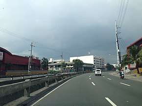 Gregorio Araneta Avenue near the Calamba Street intersection, before the construction of the Skyway Stage 3. | |
| Route information | |
| Maintained by Department of Public Works and Highways | |
| Length | 5.3 km (3.3 mi) |
| Component highways |
|
| Major junctions | |
| North end | |
| |
| South end | Nicanor Domingo Street in San Juan |
| Location | |
| Major cities | Quezon City and San Juan |
| Highway system | |
| |
.svg.png)
The avenue lies in a flood-prone zone in close proximity to the San Francisco del Monte and San Juan Rivers. It was named after lawyer and landowner Gregorio S. Araneta who owned the Santa Mesa Heights Subdivision on which the avenue was built.[1]
A man-made waterway median runs through the middle of the road, that momentarily terminates in the Del Monte Avenue intersection, and continues immediately, terminating before the Quezon Avenue intersection. As a result of the Skyway Stage 3 project, parts of the waterway median will be converted into a closed culvert and will become a part of the passable road.

The Manila Skyway Stage 3 will traverse almost the entire length of the road, starting from Sergeant Rivera Street down to San Juan River.
Funeral row
Gregorio Araneta Avenue is best known as the location of some of the biggest funeral parlors in the metropolis. These are the Arlington Memorial Chapels, La Funeraria Paz, Ascension Columbary, Cosmopolitan, Nacional Memorial Homes, and the Sanctuarium (formerly Capitol Memorial). The oldest is Funeraria Nacional which moved to Gregorio Araneta from its old address in downtown Avenida Rizal in 1968. It was followed by La Funeraria Paz in the 1970s and Arlington, which converted the old Thomas Jefferson Library on the avenue into a funeral facility, in 1985.[2]
Automated Trash Rake
In 2014, the Department of Science and Technology built an automated garbage rake in the intersection of Araneta Avenue and Mauban Street, functioning as a cleaning facility for the river, in response to the perennial flooding and garbage problems in the area. Garbage trucks regularly collected garbages that were captured from the river, as well as those dumped nearby.[3]
Intersections
| Province | City/Municipality | km | mi | Destinations | Notes |
|---|---|---|---|---|---|
| Quezon City | Santo Domingo Avenue | Continues north as | |||
| Valentin Ventura Street | Northbound only | ||||
| Mauban Street | Former unsignaled intersection. Temporarily closed off due to Skyway construction. | ||||
| G. Roxas Street | Southbound only | ||||
| Del Monte Avenue | Traffic light intersection. Access to Siena College, San Francisco del Monte district, and A. Bonifacio Avenue. | ||||
| Norberto S. Amoranto Sr. (Retiro) Avenue / C. Adan Street | Traffic light intersection. Access to La Loma district and the districts of Sampaloc and Santa Cruz in Manila. | ||||
| Calamba Street | Opposite segments accessible through nearby roads. | ||||
| Skyway | Skyway-Quezon Avenue Exit. Future southbound entrance. | ||||
| Maria Clara Street | Unsignaled intersection | ||||
| Skyway | Skyway-Quezon Avenue Exit. Future northbound exit. | ||||
| P. Florentino Street | Opposite segments accessible through nearby roads. | ||||
| Traffic light intersection. No left turns formerly, until alterations due to the Skyway Stage 3 construction made it necessary; the U-Turn slots far ahead brought more traffic than what it was built to avert. | |||||
| Agno Street Extension | Opposite segments accessible through nearby roads. | ||||
| ROTC Hunters Street | Northbound only | ||||
| Skyway | Skyway-Quezon Avenue Exit. Future southbound entrance and northbound exit. | ||||
| Kaliraya Road | Unsignaled intersection | ||||
| Victory Avenue | Unsignaled intersection | ||||
| Kitanlad Street | Southbound only | ||||
| E. Rodriguez Sr. Avenue | Traffic light intersection, No left turns and no U-turns; U-Turn slot located ahead. | ||||
| Kapiligan Street | Northbound only | ||||
| Tomas Arguelles Street | Southbound only | ||||
| Skyway | Skyway-E. Rodriguez Exit. Future southbound entrance. | ||||
| Bayani Street | Traffic light intersection | ||||
| Baloy Street | Unsignaled intersection | ||||
| Landargun Street | Unsignaled intersection | ||||
| Tamar Street | Southbound only. Fenced-off entry. | ||||
| Palanza Street | Traffic light intersection | ||||
| Skyway | Skyway-Aurora Avenue on-ramp. Future northbound exit.[4] | ||||
| Southern terminus of N130; change to unnumbered route.[5] No left turns from Magsaysay Boulevard eastbound; instead served by a U-Turn slot. | |||||
| Quezon City–San Juan boundary | San Juan-Santa Mesa Bridge over San Juan River | ||||
| San Juan | Skyway | Future northbound exit[6] | |||
| Nicanor Domingo Street | Southern terminus. Access to Santa Mesa in Manila, New Manila and Cubao in Quezon City, and Mandaluyong. | ||||
1.000 mi = 1.609 km; 1.000 km = 0.621 mi
| |||||
References
- History and Important Events of Sta. Teresita Parish published by the National Shrine of Our Lady of Lourdes in Quezon City. Retrieved December 19, 2013.
- QC's Araneta Avenue: Showcase strip for the Filipino 'burol' published by the Philippine Daily Inquirer. Retrieved December 19, 2013.
- http://quezoncity.gov.ph/index.php?option=com_content&view=article&id=1501:dost-turns-over-automatic-trash-rake-facility-to-qc-lgu&catid=1:latest-news&Itemid=362
- Metro Manila Skyway Stage 3 update as of March 2020. March 7, 2020. Retrieved May 21, 2020.
- "NCR". Department of Public Works and Highways. Retrieved May 25, 2020.
- Pornelos, Vince (September 5, 2019). "Here's your first look at the Quezon City segment of Skyway Stage 3". Autoindustriya.com. Retrieved May 17, 2020.