Magsaysay Boulevard
President Ramon Magsaysay Boulevard, simply known Magsaysay Boulevard, is the principal artery of Santa Mesa in Manila, Philippines. It is a six-lane divided roadway that travels east-west from Gregorio Araneta Avenue near the city's border with Quezon City and San Juan to Lacson Avenue and the Nagtahan Interchange, close to the district of San Miguel. The entire length of the boulevard serves as the boundary between Sampaloc in the north and Santa Mesa in the south with the Manila Light Rail Transit System Line 2 running along its median. East of Gregorio Araneta, the road continues as Aurora Boulevard while west of Lacson, it extends as Legarda Street via Legarda Flyover into San Miguel and Quiapo.
| |
|---|---|
| Santa Mesa Boulevard | |
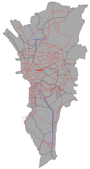 The route of Magsaysay Boulevard in Metro Manila. Magsaysay Boulevard is highlighted in red. | |
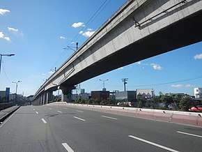 On the eastbound lanes of Magsaysay Boulevard near Pureza station | |
| Route information | |
| Length | 2.2 km (1.4 mi) |
| Component highways | |
| Major junctions | |
| West end | |
| |
| East end | |
| Location | |
| Major cities | Manila and Quezon City |
| Highway system | |
| |
.svg.png)

The Manila Line 2 has two stations along Magsaysay, namely Pureza and V. Mapa. It is also served by the Santa Mesa railway station near the Polytechnic University of the Philippines campus on Hipodromo and Anonas Streets.
The boulevard was named after the seventh president of the Philippines, Ramon Magsaysay. It was formerly called Santa Mesa Boulevard.[1]
Route
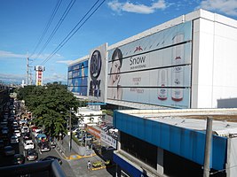
Magsaysay Boulevard is an all-divided road that starts as a continuation of Legarda Street past A.H. Lacson Avenue. The Manila Line 2 follows wholly the length of the road, with two stations, built above. The road has numerous traffic light intersections and side streets throughout its length. Various major establishments, like the Polytechnic University of the Philippines, Sogo Grand Hotel, and SM City Santa Mesa (formerly named SM Centerpoint), lie around or near the road.
Intersections
| Province | City/Municipality | km[2] | mi | Destinations | Notes |
|---|---|---|---|---|---|
| Manila | 4.205 | 2.613 | Traffic light intersection; continues westward as | ||
| East end of Nagtahan Interchange | |||||
| M. Francisco Street | Westbound only | ||||
| Valencia Street | Eastbound only | ||||
| M. Dela Rosa Street | Westbound only | ||||
| Marzan Street | Westbound only | ||||
| Vicente Cruz Street | Westbound only | ||||
| De Dios Street | Eastbound only | ||||
| D. Ampil Street | Eastbound only | ||||
| Pureza Street | Traffic light intersection; access to Polytechnic University of the Philippines | ||||
| Maganda Street | Westbound only | ||||
| Algeria Street | Westbound only | ||||
| Fortuna Street | Eastbound only | ||||
| Hipodromo Street | Eastbound only | ||||
| Paltok Street | Westbound only | ||||
| Philippine National Railways | 4.935– 5.135 | 3.066– 3.191 | PNR Metro South Commuter Line Overpass | ||
| Manila | D. Santiago Street | Westbound only | |||
| Altura Street | Unsignaled intersection. Access to PNR Santa Mesa Station | ||||
| Old Santa Mesa Street | Traffic light intersection | ||||
| Santol Street | Traffic light intersection | ||||
| Guadalcanal Street | Eastbound only | ||||
| 5.818 | 3.615 | Traffic light intersection | |||
| Hotel Sogo Santa Mesa Access Road | Eastbound only; access to Hotel Sogo Santa Mesa | ||||
| Sociego Street | Westbound only | ||||
| Baldovino Street | Eastbound only | ||||
| Manila-Quezon City boundary | North Manila–Quezon City 2nd boundary | ||||
| Quezon City | SM City Santa Mesa Access Road | Eastbound only; access to SM City Santa Mesa | |||
| 6.306 | 3.918 | Traffic light intersection; continues eastward to Cubao as | |||
| 1.000 mi = 1.609 km; 1.000 km = 0.621 mi | |||||
See also
- Major roads in Manila
References
- Sta. Mesa: Manila's northeastern edge published by the Philippine Star; accessed 2013-10-10.
- "North Manila". 2016 DPWH data. Department of Public Works and Highways. Archived from the original on August 13, 2017. Retrieved August 13, 2017.