N651 highway (Philippines)
The N651 highway (or National Route 651 or simply Route 651) is a national secondary road in the Philippine highway network. It is one of the national secondary roads with two non-contiguous sections, one which runs through the municipality of Carmona, Cavite in the Calabarzon region[1] , while the other road runs within the island of Catanduanes in the Bicol region[2].
| ||||
|---|---|---|---|---|
| Route information | ||||
| Maintained by Department of Public Works and Highways | ||||
| Carmona Diversion Road (Cavite) | ||||
| Length | 2.53 km (1.57 mi) | |||
| West end | ||||
| East end | ||||
| Panganiban–Sabloyon Road (Catanduanes) | ||||
| Length | 26.17 km (16.26 mi) | |||
| East end | ||||
| West end | ||||
| Highway system | ||||
| ||||
.svg.png)
Route description
Cavite
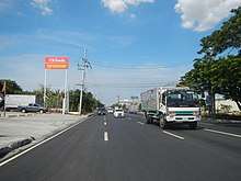
N651 runs through the section the Governor's Drive in the municipality of Carmona, Cavite, where the road known as Carmona Diversion Road. After passing the town proper, the rest of the road going to the Laguna province merged by N65.
Catanduanes
In the Catanduanes province, N651 runs through the municipalities of Panganiban and Caramoran, where the entire signed road is known as Panganiban–Sabloyon Road.
References
- "2016 DPWH Road Data - Cavite Sub". Department of Public Works and Highways. Retrieved 13 March 2018.
- "2016 DPWH Road Data - Catanduanes". Department of Public Works and Highways. Retrieved 13 March 2018.
| National primary roads |
| |||||||
|---|---|---|---|---|---|---|---|---|
| National secondary roads |
| |||||||
See also: Philippine expressway network | ||||||||
| Expressways |
| ||||||||
|---|---|---|---|---|---|---|---|---|---|
| National roads |
| ||||||||
| Arterial Routes |
| ||||||||