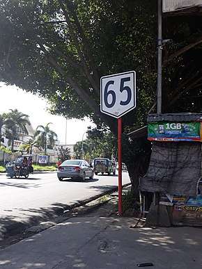
N65 highway (Philippines)
The National Route 65 (N65) forms part of the Philippine highway network. It runs through central Cavite and northern Laguna.[1][2]
| ||||
|---|---|---|---|---|
 Route reassurance sign in Trece Martires, Cavite | ||||
| Route information | ||||
| Maintained by the Department of Public Works and Highways | ||||
| Length | 27.311 km (16.970 mi) | |||
| Major junctions | ||||
| West end | ||||
| ||||
| East end | ||||
| Location | ||||
| Provinces | Cavite, Laguna | |||
| Major cities | Trece Martires, General Trias, Dasmariñas, Biñan | |||
| Towns | General Mariano Alvarez, Silang, Carmona | |||
| Highway system | ||||
| ||||
Route description
Trece Martires to Dasmariñas
Dasmariñas to Carmona
Carmona to Biñan
gollark: That is a LOT of power for some convenient wiring.
gollark: Oh, right, small interfaces, I see.
gollark: You can just feed items back into the interface.
gollark: My setup gives each thing individual interfaces.
gollark: I mean, running it all off one conduit loop, madness.
References
- "2016 DPWH Road Data". Department of Public Works and Highways. Archived from the original on 9 January 2018. Retrieved 8 March 2018.
- "Road and Bridge Inventory". www.dpwh.gov.ph. Retrieved June 22, 2020.
External links
This article is issued from Wikipedia. The text is licensed under Creative Commons - Attribution - Sharealike. Additional terms may apply for the media files.
.svg.png)