Akita Expressway
The Akita Expressway (秋田自動車道, Akita Jidōsha-dō) is a national expressway in the Tōhoku region of Japan. It is owned and operated by East Nippon Expressway Company. The Akita Expressway is numbered E7 between Kosaka and Kitakami Junctions and E46 between Kitakami and Kawabe Junctions under the MLIT's "2016 Proposal for Realization of Expressway Numbering."[4]
| |
|---|---|
| |
| Route information | |
| Length | 210.0 km[1] (130.5 mi) |
| Existed | 1991[3]–present |
| Major junctions | |
| From | Kitakami Junction in Kitakami, Iwate * |
| To | Kosaka Junction in Kosaka, Akita * |
| Location | |
| Major cities | Yokote, Daisen, Akita, Noshiro, Ōdate |
| Highway system | |
| National highways of Japan Expressways of Japan | |

Overview
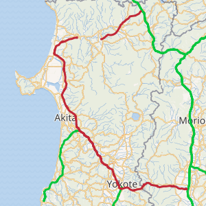
The expressway begins at a junction with the Tōhoku Expressway in Iwate Prefecture and crosses into Akita Prefecture to the west. The route intersects the Yuzawa-Yokote Road in Yokote and the Nihonkai-Tōhoku Expressway in the Akita city area. From this junction, the route follows a northerly course parallel to the Japan Sea to its terminus with National Route 7 in Noshiro.
The entire route is signed as the Akita Expressway for consistency purposes, however two separate sections of the route are officially designated as the Akita Sotokanjō Expressway and Kotooka Noshiro Road (both bypasses of National Route 7). These sections are not classified as national expressways but rather as national highways for motor vehicles only with national expressway concurrency (高速自動車国道に並行する一般国道自動車専用道路, Kōsoku Jidōsha Kokudō ni Heikōsuru Ippan Kokudō Jidōsha Senyō Dōro).[5]
The route of the expressway is planned to eventually continue past the current terminus at Futatsui-Shirakami Interchange as the Nihonkai Engan Tōhoku Expressway towards a junction with the Tōhoku Expressway near Aomori Prefecture,[5][6] however it is unknown if the naming of the sections that are currently open will change upon completion of that expressway.
The section between Hachiryū Interchange and Futatsui-Shirakami Interchange, and Ōdate-Noshiro Airport Interchange and Ōdate-kita Interchange are toll-free;[2] all other sections assess tolls based on distance travelled in the same manner as most other national expressways.
Official designations
List of interchanges and features
- IC - interchange, JCT - junction, SA - service area, PA - parking area, BS - bus stop, TN - tunnel, BR - bridge, TB - toll gate
| No. | Name | Connections | Dist. from Origin |
Dist. from Terminus |
Bus Stop | Notes | Speed Limit | Lanes | Location | |
|---|---|---|---|---|---|---|---|---|---|---|
| (37) | Kitakami JCT | 0.0 | 186.7 | 70 km/h | Two | Kitakami | Iwate | |||
| 1 | Kitakami-nishi IC | Pref. Route 47 (Kitakami-nishi Inter Route) Pref. Route 225 (Kitakami Waga Route) |
8.7 | 178.0 | ||||||
| TN | Waga-Sennin Tunnel | ↓ | ↑ | Length - 3,776 m | ||||||
| Nishiwaga | ||||||||||
| SA | Kinshūko SA | 21.4 | 165.3 | |||||||
| 2 | Yuda IC | 30.3 | 156.4 | |||||||
| TN | Sannai Tunnel | ↓ | ↑ | Length - 2,439 m | Yokote | Akita | ||||
| PA | Sannai PA | 41.0 | 145.7 | |||||||
| BS | Sannai Bus Stop | 43.2 | 143.5 | ○ | ||||||
| 3 | Yokote IC/JCT | 50.6 | 136.1 | |||||||
| 80 km/h | Four | |||||||||
| BS | Hiraka Bus Stop | 52.7 | 134.0 | ○ | ||||||
| BS | Asahi Bus Stop | 57.6 | 129.1 | ○ | ||||||
| 70 km/h | Two | |||||||||
| BS | Kakumagawa Bus Stop | 65.8 | 120.9 | ○ | Daisen | |||||
| BR | Omonogawa Bridge | ↓ | ↑ | Omono River crossing Length - 549 m | ||||||
| Yokote | ||||||||||
| PA | Ōmori PA | 68.9 | 117.8 | |||||||
| Daisen | ||||||||||
| 4 | Ōmagari IC | 71.5 | 115.2 | |||||||
| 80 km/h | Four | |||||||||
| BS | Nangai Bus Stop | 78.3 | 108.4 | ○ | ||||||
| 4-1/SA | Nishisenboku IC/ SA |
88.0 | 98.7 | IC: Open 06:00-22:00 | ||||||
| BR | Omonogawa Bridge | ↓ | ↑ | Omono River crossing | ||||||
| 5 | Kyōwa IC | 95.4 | 91.3 | |||||||
| 5-1 | Kawabe JCT | 103.8 | 82.9 | Beginning of end of |
Akita | |||||
| 6 | Akita-minami IC | 106.7 | 80.0 | |||||||
| 70 km/h | Two | |||||||||
| 7 | Akita-chūō IC | Pref. Route 62 (Akita Kitanoda Route) | 113.7 | 73.0 | ||||||
| PA | Taiheizan PA | 117.9 | 68.8 | |||||||
| 8 | Akita-kita IC | Pref. Route 72 (Akita-kita Inter Route) | 122.9 | 63.8 | ||||||
| 9 | Shōwa-Ogahantō IC | 132.4 | 54.3 | |||||||
| 10 | Gojōme- Hachirōgata IC |
Pref. Route 15 (Akita Hachirōgata Route) | 143.5 | 43.2 | Gojōme | |||||
| SA | Hachirōko SA | 150.4 | 36.3 | Mitane | ||||||
| 11/TB | Kotooka-Moritake IC/TB | Pref. Route 37 (Kotooka Kamikoani Route) | 153.1 | 33.6 | ||||||
| 12 | Hachiryū IC | 166.1 | 20.6 | |||||||
| 13 | Noshiro-minami IC | 170.2 | 16.5 | Noshiro | ||||||
| 14 | Noshiro-higashi IC | Pref. Route 64 (Noshiro Futatsui Route) |
176.7 | 10.0 | ||||||
| 15 | Futatsui- Shirakami IC |
Pref. Route 317 (Nishimeya Futatsui Route) |
186.7 | 0.0 | ||||||
| Planned route Through to | ||||||||||
| 23 | Ōdate-Noshiro Airport IC | Pref. Route 324 (Ōdate-Noshiro Airport East Route) Pref. Route 325 (Ōdate-Noshiro Airport West Route) |
0.0 | 37.2 | 70 km/h | Two | Kitaakita | Akita | ||
| 24 | Takanosu IC | 1.7 | 35.5 | |||||||
| TN | Sakae Tunnel | ↓ | ↑ | Length - 562 m | ||||||
| TN | Matoyama Tunnel | ↓ | ↑ | Length - 3,333 m | ||||||
| Ōdate | ||||||||||
| 25 | Niida-Manaka IC | Pref. Route 52 (Hinai Tashiro Route) | 13.9 | 23.3 | ||||||
| 26 | Ōdate-minami IC | 16.5 | 20.7 | |||||||
| TN | Katayama Tunnel | ↓ | ↑ | Length - 420 m | ||||||
| 27 | Ōdate-kita IC | 21.1 | 16.1 | |||||||
| PA | Shakanai PA | 22.7 | 14.5 | |||||||
| TN | Ōshigenai Daiichi Tunnel | ↓ | ↑ | Length - 1,823 m | ||||||
| TN | Ōshigenai Daini Tunnel | ↓ | ↑ | Length - 2,988 m | ||||||
| TN | Yukisawa Daiichi Tunnel | ↓ | ↑ | Length - 2,553 m | ||||||
| TN | Yukisawa Daini Tunnel | ↓ | ↑ | Length - 1,849 m | ||||||
| Kosaka | ||||||||||
| 28/TB | Kosaka-kita IC Kosaka TB |
36.7 | 0.5 | IC: Kosaka-bound exit, Ōdate-bound entrance only | ||||||
| 15 | Kosaka JCT | 37.2 | 0.0 | |||||||
See also


References
- "E-NEXCO Expressway Data". Archived from the original on 2007-12-13. Retrieved 2008-04-13.
- "Hokuu Shinhō, August 12, 2007". Archived from the original on October 29, 2007. Retrieved 2008-04-13.
- "History of Akita City". Archived from the original on 2011-05-18. Retrieved 2008-04-13.
- http://www.mlit.go.jp/road/sign/numbering/en/list/index.html: "Highway numbering list". Ministry of Land, Infrastructure and Transport. Browse 18 June 2019.
- Ministry of Land, Infrastructure and Transport. "High Standard Trunk Road Map" (PDF). Archived from the original (pdf) on 2011-09-20. Retrieved 2008-04-13.
- "E-NEXCO Planned Routes". Retrieved 2008-04-14.
- "E-NEXCO Drive Plaza Route Search". Archived from the original on 13 April 2008. Retrieved 2008-04-13.
External links

- (in Japanese) East Nippon Expressway Company