Daini-Michinoku Toll Road
The Daini-Michinoku Toll Road (第二みちのく有料道路 Daini Michinoku Yūryōdōro) is a two-lane toll road in Aomori Prefecture connecting the towns Rokunohe and Oirase. The Daini-Michinoku Toll Road was designated in 1987 as part of a single expressway running from the capital city of Aomori Prefecture, Aomori to the prefecture's second largest city, Hachinohe, Aomori.[1] The road is managed by the Aomori Prefecture Road Public Corporation and is numbered E4A as an extension of the Tōhoku Expressway.[2][3]
| |
|---|---|
| 国道号 | |
| Route information | |
| Maintained by Aomori Prefecture Road Public Corporation | |
| Length | 8.3 km (5.2 mi) |
| Existed | December 18, 1992–present |
| Major junctions | |
| North end | Rokunohe, Aomori. Aomori Prefecture Route 10 |
| Rokunohe Interchange | |
| South end | Oirase, Aomori. Shimodamomoishi Interchange |
| Highway system | |
| National highways of Japan Expressways of Japan | |
Tolls
The toll gate for the Daini-Michinoku Toll Road does not correspond to ETC when travelling north from the Hachinohe Expressway and origins further south. In this case, the driver can pull the ETC card out of the on-board unit and present it to the toll operator, where the toll must be settled by a cash payment. When the gate is approached from the north the driver can pay with cash, coupons, or simply pass through the ETC gate.[4] Otherwise, prices for use of just the Daini-Michinoku Toll Road are as follows:
Route description
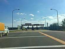
From its southern terminus with Momoishi Road, the Daini-Michinoku Toll Road travels north from the Shimodamomoishi Interchange in Oirase. The speed limit for the toll road is 60 km/h. The road quickly enters an agricultural area after its start. Three kilometers from the Shimodamomoishi Interchange the road meets its toll booth. There are two gates servicing traffic in each direction. A parking area is available for drivers to access their ETC cards before proceeding through the gate. At the booth the road proceeds northwest. Approximately 3.6 kilometers from the booth the road meets Aomori Prefecture Road 10 at a tolled interchange. Shortly after the interchange, the road gradually curves north. Along the gradual curve, the toll road continues on a ramp exiting to the left from the Kamikita Expressway. The Kamikita Expressway continues north toward Aomori. The ramp carries the toll road on to its northern terminus at an at-grade junction with Aomori Prefecture Road 10 at the southern city limits of Misawa.[5]
Future
The toll road is planned to be incorporated into a single expressway that extends north and west to connect with the Aomori Expressway and the northern terminus of the Tōhoku Expressway at the Aomori Interchange. This will be done by linking the Kamikita Expressway and Michinoku Toll Road to the Aomori Expressway.[6]
Junction list
The entire toll road is in Aomori Prefecture.
| Location | km | mi | Exit | Name | Destinations | Notes | |
|---|---|---|---|---|---|---|---|
| Rokunohe | 0 | 0.0 | — | Rokunohe | E4A continues north as the Kamikita Expressway | ||
| Oirase | 2.2 | 1.4 | — | Misawa-Towada-Shimoda | |||
| 5.6 | 3.5 | TB | Shimoda Toll Booth | Northern end of tolled section | |||
| 8.3 | 5.2 | 8 | Shimoda Momishi | End of concurrency with National Route 45; E4A continues south as Momoishi Road; tolls continue south along E4A. | |||
1.000 mi = 1.609 km; 1.000 km = 0.621 mi
| |||||||
See also


References
- "第四次全国総合開発計画" (PDF). 2006-02-09. Retrieved 2017-10-26.
- "上北天間林道路". 上和田国道維持出張所. Retrieved 2017-10-26.
- "Highway numbering list". Ministry of Land, Infrastructure and Transport. Retrieved May 15, 2017.
- "<八戸道>青森初のスマートIC 来月23日に八戸西開業". Kahoku Shimpō (in Japanese). 15 February 2019. Retrieved 8 April 2019.
- "青森県道路公社". aodoko.or.jp. Retrieved 2017-10-31.
- http://www.pref.aomori.lg.jp/kotsu/build/koukikakudouro_kako_ibennto.html: "Past Events List". Aomori Prefecture Road Administration. Browse Dec. 30, 2017.