Isewangan Expressway
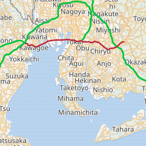
The Isewangan Expressway (伊勢湾岸自動車道, Isewangan Jidōshadō) is a national expressway in the Tōkai region of Japan. It is owned and operated by Central Nippon Expressway Company.
| |
|---|---|
| 伊勢湾岸自動車道 | |
| |
| Route information | |
| Length | 56.4 km[1] (35.0 mi) |
| Existed | 1985[2]–present |
| Major junctions | |
| From | Toyota-higashi Junction in Toyota, Aichi |
| To | Yokkaichi-kita Junction in Yokkaichi, Mie |
| Location | |
| Major cities | Nagoya, Kuwana |
| Highway system | |
| National highways of Japan Expressways of Japan | |
Naming
The route primarily follows the north shore of Ise Bay (wangan means bayshore in Japanese).
Officially, the route has 3 designations. The section from Toyota-higashi Junction to Tōkai Junction is referred to as part of the Second Tōkai Expressway.[3] The section from Tōkai Junction to Tobishima Interchange is referred to as part of National Route 302.[4] This section is not classified as a national expressway but rather as a national highway for motor vehicles only with national expressway concurrency. There is no difference in the design standard of this section compared with the rest of the expressway. Finally, the section from Tobishima Interchange to Yokkaichi-kita Junction is referred to as part of the Kinki Expressway Nagoya Kobe Route.[3]
Overview
The Isewangan is planned to link the future Shin-Tōmei Expressway to the east and Shin-Meishin Expressway to the west. These 3 expressways will replace the Tōmei Expressway and Meishin Expressway as the primary roadway linking Tokyo, Nagoya, and Osaka.
The first segment (Meikō-Chūō Interchange to Tobishima Interchange) was opened in 1985 as the Isewangan Road and the most recent addition was opened in 2005.[2] The final segment (Yokkaichi Junction to Yokkaichi-kita Junction) is planned to connect with extensions to the Shin-Meishin Expressway and Tōkai-Kanjō Expressway. The route is 6 lanes for its entire length.
The expressway features several impressive bridges. Three bridges span the Nagoya Port area (collectively known as the Meikō Triton) and two bridges span the Kiso River and Ibi River (collectively known as the Twinkle Bridges).
List of interchanges and features
- IC - interchange, JCT - junction, PA - parking area, BR - bridge
| No. | Name | Connections | Dist. from Origin |
Dist. from Terminus |
Notes | Location | |
|---|---|---|---|---|---|---|---|
| Through to | |||||||
| 1 | Toyota-higashi JCT | 0.0 | 56.4 | Toyota | Aichi | ||
| BR | Toyota Arrows Bridge | ↓ | ↑ | Yahagi River crossing Cable-stayed bridge, Length - 820 m | |||
| 2 | Toyota-higashi IC | 3.1 | 53.3 | ||||
| (19-1) | Toyota JCT | 5.0 | 51.4 | ||||
| 3 | Toyota-minami IC | Pref. Route 56 (Nagoya Okazaki Route) | 12.6 | 43.8 | |||
| PA | Kariya PA | 15.9 | 40.5 | Highway Oasis | Kariya | ||
| 4 | Toyoake IC | Pref. Route 57 (Seto Ōbu Tōkai Route) |
20.2 | 36.2 | Toyoake | ||
| 5 | Nagoya-minami JCT | 25.5 | 30.9 | Midori-ku, Nagoya | |||
| Nagoya-minami IC | Toyota-bound exit, Yokkaichi-bound entrance only | ||||||
| 6 | Ōbu IC | 27.0 | 29.4 | Ōbu | |||
| Tōkai | |||||||
| 7 | Tōkai IC | 29.9 | 26.5 | ||||
| 7-1 | Tōkai JCT | ||||||
| BR | Meikō-higashi Bridge | ↓ | ↑ | Cable-stayed bridge Length - 700 m | |||
| Minato-ku, Nagoya | |||||||
| 8 | Meikō-Shiomi IC | Pref. Route 225 (Nagoya Higashi Kō Route) | 32.4 | 24.0 | |||
| BR | Meikō-chūō Bridge | ↓ | ↑ | Cable-stayed bridge Length - 1,170 m | |||
| 9 | Meikō-chūō IC | 34.8 | 21.6 | ||||
| BR | Meikō-nishi Bridge | ↓ | ↑ | Cable-stayed bridge Length - 758 m | |||
| Tobishima | |||||||
| 10 | Tobishima IC | 37.6 | 18.8 | ||||
| - | Tobishima JCT | - | - | opening in 2020 | |||
| 11 | Wangan-Yatomi IC | Pref. Route 71 (Nagoya Nishi Kō Route) | 40.5 | 15.9 | Yokkaichi-bound exit, Toyota-bound entrance only | Yatomi | |
| 12 | Yatomi-Kisozaki IC | Pref. Route 103 (Yokkaichi Suzuka Route) | 43.3 | 13.1 | Toyota-bound exit, Yokkaichi-bound entrance only | ||
| BR | Kisogawa Bridge | ↓ | ↑ | Length - 1,145m | |||
| Kuwana | Mie | ||||||
| 13/PA | Wangan-Nagashima IC/PA | Pref. Route 7 (Suigō Kōen Route) | 45.9 | 10.5 | |||
| BR | Ibigawa Bridge | ↓ | ↑ | Length - 1,397m | |||
| 14 | Wangan-Kuwana IC | Pref. Route 69 (Wangan-Kuwana Inter Route) | 48.4 | 8.0 | |||
| BR | Inabegawa Bridge | ↓ | ↑ | ||||
| Kawagoe | |||||||
| 15 | Mie-Kawagoe IC | Pref. Route 401 (Kuwana Yokkaichi Route) |
50.2 | 6.2 | |||
| 16 | Mie-Asahi IC | Pref. Route 66 (Yokkaichi Asahi Route) | 54.2 | 2.2 | Toyota-bound exit, Yokkaichi-bound entrance only | Yokkaichi | |
| (29-1) | Yokkaichi JCT | 56.4 | 0.0 | ||||
| Through to | |||||||
Gallery
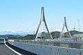 Toyota Arrows Bridge
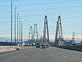 Meikō Triton view from the west
 Meikō-higashi Bridge
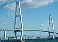 Meikō-chūō Bridge
 Meikō-nishi Bridge
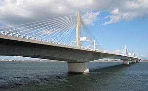 Twinkle Kisogawa Bridge
 Twinkle Kisogawa Bridge
_with_Nagashima_spaland.jpg) Twinkle Ibigawa Bridge and Nagashima Spaland
Twinkle Ibigawa Bridge and Nagashima Spaland Twinkle Ibigawa Bridge at night
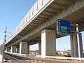 Furukawa Viaduct
References
- Ministry of Land, Infrastructure and Transport. "Road Timetable". Archived from the original on 2008-03-14. Retrieved 2008-04-17.
- Ministry of Land, Infrastructure and Transport. "History of the Expressway Network in the Greater Nagoya Area". Archived from the original on 2008-03-28. Retrieved 2008-04-17.
- Ministry of Land, Infrastructure and Transport. "High Standard Trunk Road Map" (PDF). Archived from the original (pdf) on 2011-09-20. Retrieved 2008-04-13.
- Aichi Prefectural Government. "Toll Road Information". Retrieved 2008-05-19.
External links
| National Expressways | |
|---|---|
| Toll Roads | |