Kyushu Expressway
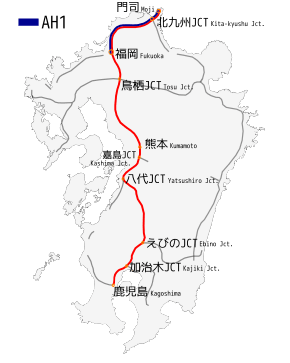
Kyushu Expressway (九州自動車道, Kyūshū Jidōsha-dō) (Asian Highway Network ![]()
| |
|---|---|
 | |
| Route information | |
| Part of | |
| Length | 346.2 km[1] (215.1 mi) |
| Existed | 1971–present |
| Major junctions | |
| From | Moji Interchange in Kitakyushu, Fukuoka |
| To | Kagoshima Junction in Kagoshima, Kagoshima |
| Location | |
| Major cities | Fukuoka, Dazaifu, Tosu, Kurume, Kumamoto, Yatsushiro, Kirishima |
| Highway system | |
| National highways of Japan Expressways of Japan | |

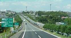
Kumamoto,Japan
History
- June 30, 1971, a section from Ueki to Kumamoto was opened to traffic
- October 21, 1972, a section from Nankan to Ueki opened to traffic
- November 16, 1973, Tosu Interchange and Junction to Nankan was opened to traffic
- December 13, 1973, Kajiki Interchange to Satsuma-Yoshida was opened to traffic
- March 13, 1975, Koga Interchange to Tosu Junction was opened to traffic
- March 4, 1976, Ebuno Junction with the Miyazaki Expressway to Ebuno Interchange was opened.
- November 26, 1976, The section was opened to traffic from Kumatoto to Mifune Interchanges
- November 29, 1976, a section from Mizobe Kagoshimna Airport to Kajiki Interchanges was opened
- July 21, 1977, a section from Wakamiya to Koga was open to traffic
- November 15, 1977, a section from Satsuma-Yoshida to Kagoshima-Kita Interchanges was opened
- December 15, 1978, a section from Mifune to Matsubase Interchanges was opened
- March 8, 1979, a section from Wakamiya to Yahata Interchanges was opened
- March 12, 1980, a section from Matsubase to Yatsushiro Interchanges was opened
- March 22, 1980 a section from Kurino to Mizobe-Kagoshima Airport was opened
- October 1, 1981, a section from Ebuno Junction to Kurino Interchange opened made that section ran from Ebuno to Kagoshima-Kita interchanges that time
- March 27, 1984, a section from Moji to Kokura-Higashi was opened which made access to the bridge with Honshū
- March 28, 1985, the Tosu Junction in the west was opened.
- February 5, 1987, the Tosu Junction in the east was opened.
- March 29, 1988, a section from Kagoshima-Kita to Kagoshima was opened with an interchange with the expressway.
- March 31, 1988, a section from Kokura-Higashi to Yahata was opened to traffic
- October 19, 1988, a section in the Kagoshima Interchange with the Minami Kyushu Expressway was opened
- December 7, 1989, a section from Yatsushiro to Hitoyoshi was opened to traffic
- March 25, 1992, a section in the Kajiki Interchange with the road was opened
- March 31, 1993, the Shin-Moji Interchange was opened
- July 27, 1995, a section from Hitoyoshi to Ebuno was opened to traffic which made the Kyushu Expressway from Moji to Kagoshima fully accessible with no gaps.
- April 20, 1998, the Yatsushiro Junction was opened to traffic with another freeway
- December 19, 2001, Kajiki Junction was opened to traffic
- December 12, 2004, the tunnel from Hitoyoshi to Ebino Interchanges which made Kyushu Expressway with four lanes now being connected with no gaps
- February 26, 2006, Kitakyushu Junction was opened to traffic with another freeway
- March 29, 2009, the Miyama-Yanagawa Interchange was opened
- February 19, 2011, the Kurate Interchange was opened
- April 14, 2016, Many sections of the expressway were damaged during the 2016 Kumamoto earthquakes.
- April 29, 2016, The expressway reopened.[2]
List of interchanges and features
- IC - interchange, SIC - smart interchange, JCT - junction, SA - service area, PA - parking area, BS - bus stop, TN - tunnel, TB - toll gate, BR - bridge
- Bus stops labeled "○" are currently in use; those marked "◆" are closed.
| Number | Name | Connections | Distance from Moji(Km) |
Bus Stop | Notes | Location | |
|---|---|---|---|---|---|---|---|
| Through to | |||||||
| 1 | Moji IC | Pref. Route 72 (Kurokawa Shiranoe Higashihonmachi Route) |
0.0 | Moji-ku, Kitakyūshū | Fukuoka | ||
| - | Hata BS | - | 4.1 | ◆ | |||
| 1-1 | Shin-Moji Interchange | Pref. Route 71 (Shin-Moji Port Dairi Route) | 4.4 | Only accessible for Fukuoka | |||
| - | Kishi PA | - | 6.2 | ||||
| - | Kuzuhara BS | - | 11.2 | ◆ | Kokuraminami-ku, Kitakyūshū | ||
| 2 | Kokura-Higashi IC | 13.4 | |||||
| 2-1 | Kitakyushu JCT | 16.5 | |||||
| 3 | Kokura-Minami IC | 20.2 | ○ | ||||
| 4 | Yahata IC | 31.4 | ○ | Kitakyushu Expressway←→Hiroshima: no access | Yahatanishi-ku, Kitakyūshū | ||
| - | Nogata PA | - | 34.9 | ○ | Only accessible for Hiroshima | Nogata | |
| 4-1 | Kurate IC | Pref. Route 472 (Nogata Kurate Route) | 36.1 | Kurate | |||
| - | Kurate PA | - | 36.3 | Only accessible for Fukuoka | |||
| 4-2 | Miyata SIC | Pref. Route 9 (Muroki Shimoariki Wakamiya Route) via Miyawaka city road | 42.1 | Only accessible for Fukuoka | Miyawaka | ||
| 5 | Wakamiya IC | Pref. Route 9 (Muroki Shimoariki Wakamiya Route) | 45.2 | ○ | |||
| - | Koga SA | - | 54.5 | Koga | |||
| 6 | Koga IC | Pref. Route 35 (Chikushino Koga Route) |
57.7 | ||||
| - | Aoyagi BS | - | 58.7 | ○ | |||
| - | Tachibanayama BS | - | 62.9 | ○ | Shingu | ||
| Hisayama | |||||||
| 7 | Fukuoka IC | 68.3 | ◆ | Higashi-ku, Fukuoka | |||
| 7-1 | Sue PA/SIC | Pref. Route 91 (Shime Sue Route) | 73.4 | ◆ | Sue | ||
| - | Umi BS | - | 75.4 | ○ | Umi | ||
| 8 | Dazaifu IC | 80.1 | ◆ | Dazaifu | |||
| - | Chikushino BS | - | 84.9 | ○ | Chikushino | ||
| 8-1 | Chikushino IC | Pref. Route 7 (Chikushino Interchange Route) | 86.9 | ||||
| - | Kiyama PA | - | 90.8 | ○ | Kiyama | Saga | |
| 9 | Tosu JCT/IC | 96.1 | Tosu | ||||
| - | Ajisaka SIC | Planned | Ogōri | Fukuoka | |||
| - | Miyanojin BS | - | 102.5 | ○ | Kurume | ||
| 10 | Kurume IC | 105.4 | ○ | ||||
| 10-1 | Hirokawa IC | Pref. Route 84 (Hirokawa Jōyō Route) | 113.2 | ○ | Bus stop: northbound only | Hirokawa | |
| - | Hirokawa SA | - | 113.6 | ○ | Bus stop: southbound only Hirokawa IC←→SA: no access | ||
| 11 | Yame IC | 118.4 | ○ | Yame | |||
| Chikugo | |||||||
| - | Setaka BS | - | 122.4 | ○ | Miyama | ||
| 11-1 | Miyama-Yanagawa IC | Pref. Route 775 (Motoyoshi Ogawa Route) | 125.6 | ||||
| - | Yamakawa PA | - | 128.0 | ○ | |||
| 12 | Nankan IC | Pref. Route 5 (Omuta Nankan Route) Pref. Route 10 (Nankan Omuta-Kita Route) |
135.0 | Nankan | Kumamoto | ||
| - | Kobaru BS | - | 138.8 | ○ | |||
| - | Tamana PA | - | 142.7 | ||||
| 13 | Kikusui IC | Pref. Route 16 (Tamana Yamaga Route) | 146.6 | ○ | Nagomi | ||
| - | Kaou BS | - | 153.6 | ○ | Yamaga | ||
| 14 | Ueki IC | 157.3 | ○ | Kita-ku, Kumamoto | |||
| 14-1 | Kita-Kumamoto SIC | Pref. Route 30 (Ozu Ueki Route) via Kumamoto city road | 162.0 | ||||
| - | Kita-Kumamoto SA | - | 162.2 | ||||
| - | Nishi-Kōshi BS | - | 165.7 | ○ | Kōshi | ||
| - | Musashigaoka BS | - | 169.0 | ○ | Kita-ku, Kumamoto | ||
| 15 | Kumamoto IC | 171.2 | Higashi-ku, Kumamoto | ||||
| - | Takuma PA | - | 174.3 | ||||
| 15-1 | Mashiki-Kumamoto Airport IC | Pref. Route 36 (Kumamoto Mashiki Ozu Route) | 176.4 | Mashiki | |||
| - | Mashiki BS | - | 177.5 | ○ | |||
| 15-2 | Kashima JCT | 180.7 | Mifune | ||||
| 16 | Mifune IC | 183.1 | ◆ | ||||
| - | Midorikawa PA | - | 186.7 | Minami-ku, Kumamoto | |||
| Kōsa | |||||||
| 16-1 | Jōnan BS/ SIC | Pref. Route 38 (Uto Kōsa Route) | 189.0 | ○ | Minami-ku, Kumamoto | ||
| 17 | Matsubase IC | 195.1 | ◆ | Uki | |||
| 17-1 | Hikawa Takatsuka BS/Uki Hikawa SIC | 204.0 | ◆ | Hikawa | |||
| - | Miyahara SA | - | 208.8 | ○ | |||
| 18 | Yatsushiro IC | 213.5 | ○ | Yatsushiro | |||
| 18-1 | Yatsushiro JCT | 214.6 | Only accessible for Fukuoka | ||||
| - | Sakamoto PA | - | 222.1 | ◆ | |||
| - | Ayugaeri BS | - | 230.2 | ◆ | |||
| - | Higo TN | - | Length 6,340m Dangerous goods forbidden | ||||
| Yamae | |||||||
| - | Koduru BS | - | 242.4 | ◆ | |||
| - | Yamae SA | - | 248.0 | ◆ | |||
| 19 | Hitoyoshi IC | Pref. Route 54 (Hitoyoshi Interchange Route) | 252.0 | ○ | |||
| Hitoyoshi | |||||||
| - | Hitoyoshi TB | - | 252.1 | Abandoned on July 27, 1995 | |||
| 19-1 | Hitoyoshi-Kuma SIC | 256.2 | - | incl. Hitoyoshi-Minami Bus Stop BS location TBD | |||
| - | Hitoyoshi Temporary Interchange | 256.2 | Abandoned on July 27, 1995 | ||||
| - | Hitoyoshi-Minami BS | - | 256.4 | ◆ | closed by replacement | ||
| - | Kakutō TN | - | Length 6,264m Dangerous goods forbidden | ||||
| Ebino | Miyazaki | ||||||
| - | Ebino PA | - | 271.9 | ||||
| 20 | Ebino IC | 274.3 | ○ | ||||
| 21 | Ebino JCT | 276.4 | |||||
| - | Yoshimatsu PA | - | 281.6 | ○ | Yūsui | Kagoshima | |
| 22 | Kurino IC | Pref. Route 55 (Kurino Kajiki Route) | 290.0 | ||||
| 23 | Yokogawa IC | Pref. Route 55 (Kurino Kajiki Route) | 296.0 | Kirishima | |||
| - | Mizobe PA | - | 302.7 | ||||
| - | Kagoshima Airport-Minami BS | - | 308.6 | ○ | |||
| 24 | Mizobe-Kagoshima Airport IC | 309.8 | |||||
| 25-1 25 |
Kajiki JCT Kajiki IC |
Pref. Route 55 (Kurino Kajiki Route) |
317.5 | Aira | |||
| - | Chōsa BS | - | 322.2 | ○ | |||
| 25-2 | Sakurajima SA/SIC | 323.6 | SIC:Only accessible for Kagoshima | ||||
| 26 | Aira IC | Pref. Route 57 (Fumoto Shigetomi Teishajō Route) | 326.2 | ||||
| - | Honjō BS | - | 330.6 | ◆ | Kagoshima | ||
| 27 | Satsuma-Yoshida IC | Pref. Route 16 (Kagoshima Yoshida Route) | 334.8 | ||||
| - | Kagoshima TB | - | 336.7 | Toll Barrier | |||
| 28 | Kagoshima-Kita IC | Pref. Route 18 (Kagoshima-Kita Interchange Route) |
341.9 | ||||
| - | Ishiki BS | - | 342.0 | ○ | |||
| 29 | Kagoshima IC | 346.2 | |||||
| Through to Ibusuki Skyline | |||||||
- The section between Yatsushiro Junction and Ebino Interchange consists of tunnels that run in the mountainous areas; vehicles carrying dangerous goods are forbidden from travelling through these tunnels and must use alternate routes.
Lanes
- 6-lane, Dazaifu to Kurume Interchanges
- 4-lane, Moji to Dazaifu Interchange and from Kurume to Kagoshima Interchanges
gollark: YOU DON'T NEED TO WRITE OUT-OF-GAME SOFTWARE(most of the time)
gollark: Just irate.
gollark: YOU CAN WRITE SOFTWARE IN OPENCOMPUTERSTO DO STUFF INGAME
gollark: ARE YOU NOT READING ANYTHING WE'RE SAYING?
gollark: Except they're a grammar nazi and will only accept exactingly precise unambiguous Spanish.
References
- Ministry of Land, Infrastructure and Transport, Kyushu Regional Development Bureau. "Road Timetable". Retrieved 2008-08-31.CS1 maint: multiple names: authors list (link)
- "Major highway reopens in quake-hit Kumamoto". mainichi.jp. Mainichi Japan. 29 April 2016. Archived from the original on 3 June 2016. Retrieved 30 April 2016.
External links
- NEXCO West-Japan official website(in Japanese)
| Wikimedia Commons has media related to Kyushu_Expressway. |
This article is issued from Wikipedia. The text is licensed under Creative Commons - Attribution - Sharealike. Additional terms may apply for the media files.
