Sanriku Expressway
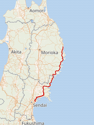
The Sanriku Expressway (三陸自動車道, Sanriku Jidōsha-dō) is an incomplete expressway that exists in multiple segments in Miyagi Prefecture and Iwate Prefecture, Japan. The expressway connects Sendai, the capital and largest city in Miyagi Prefecture, to Miyako in Iwate Prefecture. It follows the coast of the Pacific Ocean in the northern parts of the Tōhoku region, otherwise known as the Sanriku Coast. It is owned and operated by East Nippon Expressway Company (NEXCO East Japan), the Miyagi Prefecture Road Corporation, and the Ministry of Land, Infrastructure, Transport and Tourism (MLIT). The route is signed as an auxiliary route of National Route 45 as well as E6 and E45 under MLIT's "2016 Proposal for Realization of Expressway Numbering."[1] It is one of three routes numbered E45, the other two are the Sanriku-kita Jūkan Road and the Hachinohe-Kuji Expressway, and one of many routes numbered E6, although the Sanriku Expressway only carries the number close to its southern terminus in Sendai. When completed, all of these routes will form an expressway that travels from the Tokyo Gaikan Expressway in Saitama Prefecture along the Pacific Coast to Hachinohe in Aomori Prefecture.
| |
|---|---|

The Sanriku Expressway highlighted in red | |
| Route information | |
| Maintained by Ministry of Land, Infrastructure, Transport and Tourism | |
| Length | 248.1 km (154.2 mi) |
| Existed | 1982–present |
| Component highways | |
| Major junctions | |
| South end | Sendaiko-kita Interchange |
| North end | Tarō-kita Interchange |
| Highway system | |
| National highways of Japan Expressways of Japan | |
Naming
The expressway is named after the Sanriku region of northern Japan. The region was named Sanriku in the aftermath of the Boshin War, the provinces of Mutsu and Dewa were divided. Mutsu was split into new five provinces: Rikuō (also read Mutsu), Rikuchū, Rikuzen, Iwashiro and Iwaki. The first three of these collectively known as the "Three Riku", or Sanriku, with san (三) meaning "three." They are now known, respectively, as Aomori Prefecture, Iwate Prefecture, and Miyagi Prefecture. When completed the Sanriku Expressway and Sanriku-kita Jūkan Road will span these three prefectures.[2]
Future
The expressway is expected to be entirely completed by 2020 as part of a region-wide recovery effort from the 2011 Tōhoku earthquake and tsunami.[3]
Junction list
TB= Toll booth, PA= Parking Area
| Prefecture | Location | km | mi | Exit | Name | Destinations | Notes |
|---|---|---|---|---|---|---|---|
| Miyagi | Miyagino-ku, Sendai | 0.0 | 0.0 | 1 | Sendaikō-kita | ||
| Tagajō | 2.7 | 1.7 | 1-1 | Tagajō | Miyagi Prefecture Route 35 (Izumi Shiogama Route) | ||
| Rifu | 4.0 | 2.5 | 2 | Rifu | Northern terminus of E6 concurrency, southern terminus of E45 | ||
| 5.6 | 3.5 | 3 | Rifu Shiogama | Miyagi Prefecture Route 3 (Shiogama Yoshioka Route) | |||
| 7.8 | 4.8 | 4 | Rifu-naka | Miyagi Prefecture Route 8 (Sendai Matsushima Route) | Northern limit of tolling by NEXCO East, southern limit of tolling by Miyagi Prefecture Road Corporation | ||
| 9.1 | 5.7 | PA | Kasuga | ||||
| 11.8 | 7.3 | 5 | Matsushima-Kaigan | Miyagi Prefecture Route 144 (Akanuma Matsushima Route) | |||
| Matsushima | 15.9 | 9.9 | 6 | Matsushima-Ōsato | Miyagi Prefecture Route 9 (Taiwa Matsushima Route) | ||
| 19.3 | 12.0 | 7 | Matsushima-kita | ||||
| Higashimatsushima | 26.1 | 16.2 | 8/TB | Naruse-Okumatsushima | Northern terminus of toll collection by Miyagi Prefecture Road Corporation, southern terminus of section maintained by MLIT | ||
| 30.6 | 19.0 | PA | Yamoto | ||||
| 31.9 | 19.8 | 9 | Yamoto | Miyagi Prefecture Route 34 (Yamoto Kanan Route) | |||
| 36.1 | 22.4 | 10 | Ishinomakiko | Miyagi Prefecture Route 251 – to | |||
| Ishinomaki | 38.5 | 23.9 | 11 | Ishinomaki-Kanan | Miyagi Prefecture Route 16 (Ishinomaki Kashimadai Ōhira Kanan Route) – to | ||
| 40.5 | 25.2 | 11-1 | Ishinomaki-Onagawa | ||||
| 45.2 | 28.1 | 12 | Kahoku | Miyagi Prefecture Route 196 | |||
| 52.6 | 32.7 | 13 | Monō-Toyosato | Miyagi Prefecture Route 30 | |||
| 56.8 | 35.3 | 14 | Monō-Tsuyama | Miyagi Prefecture Route 61 | |||
| Tome | 66.4 | 41.3 | 15 | Tome | Miyagi Prefecture Route 4 (Ishinomaki Kashimadai Ōhira Kanan Route) – to | ||
| 71.4 | 44.4 | 16 | Tome-Tōwa | Northbound exit, southbound entrance | |||
| 73.4 | 45.6 | 16-1 | Mitakido | ||||
| Minamisanriku | 82.5 | 51.3 | 17 | Shizugawa | |||
| 85.5 | 53.1 | 18 | Minamisanriku-Kaigan | ||||
| 89.7 | 55.7 | 19 | Utatsu | ||||
| 93.7 | 58.2 | 20 | Utatsu-kita | Northbound exit, southbound entrance | |||
| Kesennuma | 99.7 | 62.0 | 21 | Koizumi-Kaigan | Northbound exit, southbound entrance | ||
| 2-kilometer-long (1.2 mi) gap in the expressway, connection is made by | |||||||
| 101.7 | 63.2 | 22 | Motoyoshitsuya | Southbound exit, northbound entrance | |||
| 103.7 | 64.4 | PA | Motoyoshi | ||||
| 105.7 | 65.7 | 23 | Ōya-Kaigan | ||||
| 108.2 | 67.2 | 23-1 | Iwaisaki | Unnamed road – to | Southbound exit, northbound entrance | ||
| 112.8 | 70.1 | 24 | Kesennuma-chūō | ||||
| 9-kilometer-long (5.6 mi) gap in the expressway, connection is made by | |||||||
| 121.8 | 75.7 | — | Karakuwa-minami | ||||
| 124.8 | 77.5 | 29 | Karakuwa-Goharagi | Northbound exit, southbound entrance | |||
| PA | Karakuwaosawa | ||||||
| Iwate | Rikuzentakata | 128.3 | 79.7 | 30 | Rikuzentakata-Taosabe | ||
| 134.8 | 83.8 | 31 | Rikuzentakata | ||||
| 138.9 | 86.3 | 32 | Kayooka | Southbound exit, northbound entrance | |||
| Ōfunato | 141.3 | 87.8 | PA | Funagawara | Parking area is only accessible for northbound traffic | ||
| 142.3 | 88.4 | 33 | Ōfunato-Goishikaigan | ||||
| 146.9 | 91.3 | — | Emergency Exit | ⛨ Iwate Prefecture Ōfunato Hospital | Emergency vehicles only | ||
| 150.9 | 93.8 | 34 | Ōfunato | ||||
| 154.5 | 96.0 | 35 | Ōfunato-kita | Southbound exit, northbound entrance | |||
| 159.9 | 99.4 | 36 | Sanriku | ||||
| 163.5 | 101.6 | 37 | Yoshihama | ||||
| Kamaishi | 168.5 | 104.7 | 38 | Kamaishi-minami | Northbound exit, southbound entrance | ||
| 171.0 | 106.3 | 39 | Kamaishi-Tōni | Southbound exit, northbound entrance | |||
| 177.5 | 110.3 | 40 | Kamaishi | ||||
| 178.4 | 110.9 | 41 | Kamaishi-chūō | ||||
| 183.1 | 113.8 | 42 | Kamaishi-Ryōishi | Iwate Prefecture Route 242 | Southbound exit, northbound entrance | ||
| 187.0 | 116.2 | 43 | Kamaishi-kita | Southbound entrance, northbound exit | |||
| Ōtsuchi | 192.5 | 119.6 | 44 | Ōtsuchi | Iwate Prefecture Route 26 | ||
| 196.3 | 122.0 | PA | Namita | ||||
| Yamada | 200.5 | 124.6 | 45 | Yamada-minami | |||
| 208.3 | 129.4 | 46 | Yamada | ||||
| 216.3 | 134.4 | 47 | Yamada-kita | Northbound exit, southbound entrance | |||
| Miyako | 220.8 | 137.2 | PA | Tsugaruishi | |||
| 222.3 | 138.1 | 48 | Miyako-minami | ||||
| 227.1 | 141.1 | 49 | Miyako-chūō | ||||
| 50 | Miyako-kita | ||||||
| 51 | Tarō-minami | Iwate Prefecture Route 177 | |||||
| 244.1 | 151.7 | 52 | Tarō-Masakikaigan | ||||
| 248.1 | 154.2 | 53 | Tarō-kita | Northbound exit, southbound entrance | |||
1.000 mi = 1.609 km; 1.000 km = 0.621 mi
| |||||||
References
- "Japan's Expressway Numbering System". www.mlit.go.jp.
- Nippon-Kichi, 三陸リアス式海岸 Sanriku-riasushiki-kaigan Saw-tooth Sanriku Coastline
- "洋野階上道路" [“Opening prospects for reconstruction roads and reconstruction support roads are "approximately 90% finalized""] (PDF) (pdf) (in Japanese). 28 October 2016. Retrieved 13 December 2018.
See also
- Joban Expressway
- Japan National Route 45
External links
- (in Japanese) Ministry of Land, Infrastructure and Transport: Tohoku Regional Development Bureau
- (in English) East Nippon Expressway Company
