Miyazaki Expressway
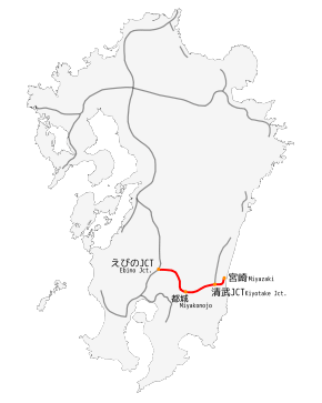
Miyazaki Expressway (宮崎自動車道, Miyazaki Jidōsha-dō) is one of the Expressways of Japan from Ebino to Miyazaki linking with the Higashikyushu Expressway. It runs through the southern half of the Miyazaki prefecture. The expressway is 80.7 kilometres (50.1 mi) long.
| |
|---|---|
| 宮崎自動車道 | |
 | |
| Route information | |
| Length | 80.7 km[1] (50.1 mi) |
| Existed | 1976–present |
| Major junctions | |
| From | Ebino Junction in Ebino |
| To | Miyazaki Interchange in Miyazaki |
| Location | |
| Major cities | Kobayashi, Miyakonojō |
| Highway system | |
| National highways of Japan Expressways of Japan | |
Tenjin Tunnel Eastern Side, Miyazaki, Japan
History
- March 4, 1976, the Ebino Junction with the Kyushu Expressway to Takaharu Interchange was opened.
- March 17, 1981, a section from Takaharu to Miyakonojō Interchanges was opened to traffic.
- October 29, 1981, a section from Miyakonojō to Miyazaki Interchanges was opened to traffic which made the Miyazaki Expressway from Ebino to Miyazaki fully accessible with no gaps.
- March 25, 2000, the Kiyotake Junction to the east was opened to traffic.
- October 1, 2005, Following privatisation of JH it came under the control of NEXCO West Japan.
Interchanges
- IC - interchange, SIC - smart interchange, JCT - junction, SA - service area, PA - parking area, BS - bus stop, TN - tunnel, BR - bridge
- Bus stops labeled "○" are currently in use; those marked "◆" are closed.
| No. | Name | Connections | Dist. from Origin |
Bus Stop | Notes | Location (all in Miyazaki) | |
|---|---|---|---|---|---|---|---|
| (21) | Ebino JCT | 0.0 | Ebino | ||||
| BS | Iino BS | 7.6 | ○ | ||||
| 1 | Kobayashi IC | Pref. Route 1 (Kobayashi Ebino Kogen Makizono Route) | 15.9 | ○ | Kobayashi | ||
| SA | Kirishima SA | 18.7 | |||||
| 2 | Takaharu IC | 26.5 | ○ | Takaharu | |||
| PA | Hyūga Takasaki PA | 30.1 | Miyakonojō | ||||
| BS | Takasaki-Higashi BS | 38.0 | ○ | ||||
| BS | Miyakonojō-Kita BS | 45.8 | ○ | ||||
| 3 | Miyakonojō IC | Miyakonojō Shibushi Road (planned) |
46.9 | ||||
| BS | Takajō BS | 50.5 | ○ | ||||
| 3-1 | Yamanokuchi SA/SIA | 51.9 | |||||
| TN | Tenjin Tunnel | northbound: 1,670 m (5,480 ft) southbound: 1,648 m (5,407 ft) |
Miyazaki | ||||
| 4 | Tano IC | Pref. Route 28 (Nichinan Takaoka Route) | 68.0 | ○ | |||
| BS | Tano-Higashi BS | 70.1 | ○ | ||||
| (4-1) | Kiyotake JCT | 74.3 | |||||
| BS | Kiyotake BS | 78.0 | ○ | ||||
| PA | Kiyotake PA | 78.7 | Only accessible for Ebino | ||||
| TB | Miyazaki TB | 79.0 | |||||
| PA | Kiyotake PA | 79.2 | Only accessible for Miyazaki | ||||
| 5 | Miyazaki IC | 80.7 | |||||
| Through to Hitotsuba Toll Road | |||||||
Lanes
- 4-lane
gollark: It would be annoying to have to constantly connect your cat to power.
gollark: How is a GPS tracking thing meant to remain *powered* for a long time?
gollark: No idea.
gollark: Also gecken and other lizards/
gollark: Cats are nice.
References
- Ministry of Land, Infrastructure and Transport, Kyushu Regional Development Bureau. "Road Timetable". Retrieved 2008-08-31.CS1 maint: multiple names: authors list (link)
| Wikimedia Commons has media related to Miyazaki_Expressway. |
This article is issued from Wikipedia. The text is licensed under Creative Commons - Attribution - Sharealike. Additional terms may apply for the media files.
