25th parallel north

The 25th parallel north is a circle of latitude that is 25 degrees north of the Earth's equatorial plane. It crosses Africa, Asia, the Indian Ocean, the Pacific Ocean, North America and the Atlantic Ocean.

25°
25th parallel north
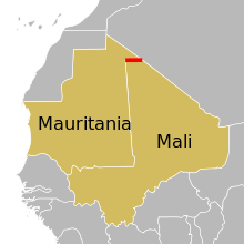
In Africa, the parallel defines part of the border between Mauritania and Mali.

The northernmost section of the border between Mauritania and Mali is defined by the parallel.[1]

At this latitude the sun is visible for 13 hours, 42 minutes during the summer solstice and 10 hours, 35 minutes during the winter solstice.[2]

Around the world

Starting at the Prime Meridian and heading eastwards, the parallel 25° north passes through:

Co-ordinates Country, territory or sea Notes
25°0′N 0°0′E  Algeria
25°0′N 10°2′E  Libya
25°0′N 25°0′E  Egypt
25°0′N 34°57′E Red Sea
25°0′N 37°17′E  Saudi Arabia
25°0′N 50°38′E Persian Gulf Gulf of Bahrain
25°0′N 50°48′E  Qatar
25°0′N 51°38′E Persian Gulf
25°0′N 55°3′E  United Arab Emirates
25°0′N 56°22′E Indian Ocean Arabian Sea
25°0′N 66°42′E  Pakistan Balochistan - for about 16 km
Sindh - passing just north of Karachi
25°0′N 70°55′E  India Rajasthan
Madhya Pradesh
Uttar Pradesh
Madhya Pradesh
Uttar Pradesh
Madhya Pradesh
Uttar Pradesh
Bihar
West Bengal
25°0′N 88°24′E  Bangladesh
25°0′N 92°25′E  India Assam
Manipur
25°0′N 94°43′E  Myanmar (Burma)
25°0′N 97°43′E  People's Republic of China Yunnan - passing just to the south of Kunming
Guizhou
Guangxi
Hunan
Guangxi
Hunan
Guangdong
Hunan
Guangdong
Jiangxi
Fujian
25°0′N 118°59′E South China Sea Taiwan Strait
25°0′N 121°1′E  Republic of China (Taiwan) Island of Taiwan (so claimed by  People's Republic of China) - passing just south of Taipei
25°0′N 121°59′E Pacific Ocean Passing just north of Miyako-jima,  Japan
Passing just north of Iwo Jima,  Japan
25°0′N 168°0′W  United States Passing through the islet of Little Rock, Gardner Pinnacles, Hawaii
25°0′N 168°0′W Pacific Ocean
25°0′N 112°12′W  Mexico Isla Magdalena
Baja California Sur mainland
Isla San José
25°0′N 110°34′W Gulf of California
25°0′N 108°13′W  Mexico Isla Altamura
Isla Talchichitle
Sinaloa
Durango
Coahuila
Nuevo León
Tamaulipas
25°0′N 97°32′W Gulf of Mexico
25°0′N 80°32′W  United States Island of Key Largo, Florida
25°0′N 80°31′W Atlantic Ocean Straits of Florida
25°0′N 78°10′W  Bahamas Island of Andros
25°0′N 77°57′W Atlantic Ocean
25°0′N 77°33′W  Bahamas Island of New Providence - passing just south of Nassau
25°0′N 77°20′W Atlantic Ocean
25°0′N 76°9′W  Bahamas Island of Eleuthera
25°0′N 76°8′W Atlantic Ocean
25°0′N 14°50′W Western Sahara Claimed by  Morocco and the  Sahrawi Arab Democratic Republic
25°0′N 12°0′W  Mauritania
25°0′N 6°34′W  Mauritania /  Mali border
25°0′N 4°49′W  Algeria
gollark: It's annoying that Big Rust doesn't want me creating custom operators.
gollark: Yes.
gollark: The target audience is basically moneyless 15 year olds.
gollark: Not really. I expect rapid breaking upon exposure to the internet.
gollark: Because once it's broken it can be arbitrarily copied.

See also

References

  1. Brownlie, Ian (1979). African Boundaries: A Legal and Diplomatic Encyclopedia. Institute for International Affairs, Hurst and Co. pp. 406–415.
  2. "Duration of Daylight/Darkness Table for One Year". Aa.usno.navy.mil. United States Naval Observatory. Retrieved June 10, 2015.
This article is issued from Wikipedia. The text is licensed under Creative Commons - Attribution - Sharealike. Additional terms may apply for the media files.