Pleugueneuc
Pleugueneuc (Breton: Plegeneg, Gallo: Ploegenoec) is a commune in the Ille-et-Vilaine department in Brittany in northwestern France.
Pleugueneuc Plegeneg | |
|---|---|
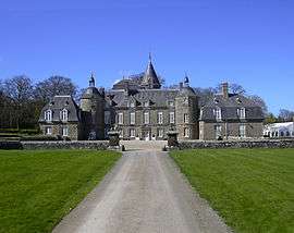 The Château de la Bourbansais, in Pleugueneuc | |
Location of Pleugueneuc 
| |
 Pleugueneuc 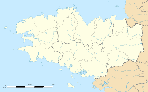 Pleugueneuc | |
| Coordinates: 48°23′50″N 1°54′09″W | |
| Country | France |
| Region | Brittany |
| Department | Ille-et-Vilaine |
| Arrondissement | Saint-Malo |
| Canton | Combourg |
| Intercommunality | Pays de la Bretagne Romantique |
| Government | |
| • Mayor (2014–2020) | Loïc Regeard |
| Area 1 | 24.52 km2 (9.47 sq mi) |
| Population (2017-01-01)[1] | 1,903 |
| • Density | 78/km2 (200/sq mi) |
| Time zone | UTC+01:00 (CET) |
| • Summer (DST) | UTC+02:00 (CEST) |
| INSEE/Postal code | 35226 /35720 |
| Elevation | 17–89 m (56–292 ft) |
| 1 French Land Register data, which excludes lakes, ponds, glaciers > 1 km2 (0.386 sq mi or 247 acres) and river estuaries. | |
Population
Inhabitants of Pleugueneuc are called Pleugueneucois in French.
| Year | Pop. | ±% |
|---|---|---|
| 1793 | 1,360 | — |
| 1800 | 1,398 | +2.8% |
| 1806 | 1,418 | +1.4% |
| 1821 | 1,453 | +2.5% |
| 1831 | 1,693 | +16.5% |
| 1836 | 1,563 | −7.7% |
| 1841 | 1,589 | +1.7% |
| 1846 | 1,669 | +5.0% |
| 1851 | 1,676 | +0.4% |
| 1861 | 1,843 | +10.0% |
| 1866 | 1,915 | +3.9% |
| 1872 | 1,941 | +1.4% |
| 1876 | 2,000 | +3.0% |
| 1881 | 2,074 | +3.7% |
| 1886 | 2,020 | −2.6% |
| 1891 | 1,991 | −1.4% |
| 1896 | 1,937 | −2.7% |
| 1901 | 1,859 | −4.0% |
| 1906 | 1,882 | +1.2% |
| 1911 | 1,938 | +3.0% |
| 1921 | 1,699 | −12.3% |
| 1926 | 1,678 | −1.2% |
| 1931 | 1,649 | −1.7% |
| 1936 | 1,523 | −7.6% |
| 1946 | 1,485 | −2.5% |
| 1954 | 1,421 | −4.3% |
| 1962 | 1,099 | −22.7% |
| 1968 | 1,232 | +12.1% |
| 1975 | 1,151 | −6.6% |
| 1982 | 1,103 | −4.2% |
| 1990 | 1,132 | +2.6% |
| 1999 | 1,283 | +13.3% |
| 2008 | 1,621 | +26.3% |
References
- "Populations légales 2017". INSEE. Retrieved 6 January 2020.
- Mayors of Ille-et-Vilaine Association (in French)
External links
| Wikimedia Commons has media related to Pleugueneuc. |
- French Ministry of Culture list for Pleugueneuc (in French)
| Authority control |
|
|---|
This article is issued from Wikipedia. The text is licensed under Creative Commons - Attribution - Sharealike. Additional terms may apply for the media files.