Pacé, Ille-et-Vilaine
Pacé (Breton: Pazieg, Gallo: Paczaé) is a commune in the Ille-et-Vilaine department of Brittany in northwestern France.
Pacé Pazieg | |
|---|---|
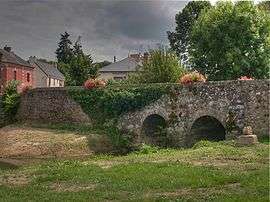 Bridge over the Flume River | |
 Coat of arms | |
Location of Pacé 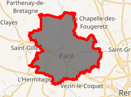
| |
 Pacé  Pacé | |
| Coordinates: 48°08′52″N 1°46′26″W | |
| Country | France |
| Region | Brittany |
| Department | Ille-et-Vilaine |
| Arrondissement | Rennes |
| Canton | Rennes-6 |
| Intercommunality | Rennes Métropole |
| Government | |
| • Mayor (2014-2020) | Paul Kerdraon |
| Area 1 | 35.03 km2 (13.53 sq mi) |
| Population (2017-01-01)[1] | 11,739 |
| • Density | 340/km2 (870/sq mi) |
| Time zone | UTC+01:00 (CET) |
| • Summer (DST) | UTC+02:00 (CEST) |
| INSEE/Postal code | 35210 /35740 |
| Elevation | 27–91 m (89–299 ft) |
| 1 French Land Register data, which excludes lakes, ponds, glaciers > 1 km2 (0.386 sq mi or 247 acres) and river estuaries. | |
Geography
Pacé is on the banks of the River Flûme, itself a tributary of the River Vilaine. Neighbouring municipalities include Gévezé to the north, La Mézière to the north-east, with La Chapelle-des-Fougeretz and Montgermont in the east. The capital of Brittany, Rennes lies to the south-east of Pacé.
The little town is positioned along the main road linking the coastal resort of Saint-Brieuc with Rennes. The road has recently (2013) been upgraded, which has significantly improved access.
Population
| Year | Pop. | ±% |
|---|---|---|
| 2005 | 8,212 | — |
| 2006 | 8,294 | +1.0% |
| 2007 | 8,651 | +4.3% |
| 2008 | 9,110 | +5.3% |
| 2009 | 9,535 | +4.7% |
| 2010 | 9,961 | +4.5% |
| 2011 | 10,488 | +5.3% |
| 2012 | 10,818 | +3.1% |
| 2013 | 11,044 | +2.1% |
| 2014 | 11,288 | +2.2% |
| 2015 | 11,531 | +2.2% |
| 2016 | 11,764 | +2.0% |
Inhabitants of Pacé are called in French pacéens.
References
- "Populations légales 2017". INSEE. Retrieved 6 January 2020.
- Mayors of Ille-et-Vilaine Association (in French)
External links
| Wikimedia Commons has media related to Pacé (Ille-et-Vilaine). |
- Official website (in French)
- French Ministry of Culture list for Pacé (in French)
| Authority control |
|
|---|
This article is issued from Wikipedia. The text is licensed under Creative Commons - Attribution - Sharealike. Additional terms may apply for the media files.