Pancé
Pancé (Breton: Pantieg, Gallo: Panczaé) is a commune in the Ille-et-Vilaine department of Brittany in northwestern France.
Pancé Pantieg | |
|---|---|
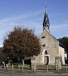 The chapel of Saint-Melaine | |
Location of Pancé 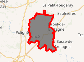
| |
 Pancé  Pancé | |
| Coordinates: 47°52′56″N 1°39′25″W | |
| Country | France |
| Region | Brittany |
| Department | Ille-et-Vilaine |
| Arrondissement | Redon |
| Canton | Bain-de-Bretagne |
| Intercommunality | Moyenne Vilaine et du Semnon |
| Government | |
| • Mayor (2014–2020) | Jean-Marie Princen |
| Area 1 | 19.33 km2 (7.46 sq mi) |
| Population (2017-01-01)[1] | 1,171 |
| • Density | 61/km2 (160/sq mi) |
| Time zone | UTC+01:00 (CET) |
| • Summer (DST) | UTC+02:00 (CEST) |
| INSEE/Postal code | 35212 /35320 |
| Elevation | 17–105 m (56–344 ft) |
| 1 French Land Register data, which excludes lakes, ponds, glaciers > 1 km2 (0.386 sq mi or 247 acres) and river estuaries. | |
Geography
The river Semnon forms all of the commune's southern border.
Population
Inhabitants of Pancé are called Pancéens in French.
| Year | Pop. | ±% |
|---|---|---|
| 1962 | 669 | — |
| 1968 | 725 | +8.4% |
| 1975 | 689 | −5.0% |
| 1982 | 763 | +10.7% |
| 1990 | 794 | +4.1% |
| 1999 | 964 | +21.4% |
| 2008 | 1,124 | +16.6% |
References
- "Populations légales 2017". INSEE. Retrieved 6 January 2020.
- Mayors of Ille-et-Vilaine Association (in French)
External links
| Wikimedia Commons has media related to Pancé. |
- French Ministry of Culture list for Pancé (in French)
This article is issued from Wikipedia. The text is licensed under Creative Commons - Attribution - Sharealike. Additional terms may apply for the media files.