Chartres-de-Bretagne
Chartres-de-Bretagne (Breton: Karnod, Gallo: Chartr) is a commune in the Ille-et-Vilaine department of Brittany in northwestern France.
Chartres-de-Bretagne Karnod | |
|---|---|
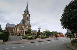 Notre Dame church | |
.svg.png) Coat of arms | |
Location of Chartres-de-Bretagne 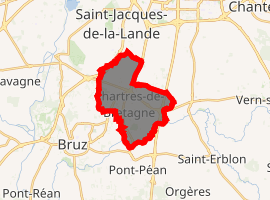
| |
 Chartres-de-Bretagne  Chartres-de-Bretagne | |
| Coordinates: 48°02′25″N 1°42′10″W | |
| Country | France |
| Region | Brittany |
| Department | Ille-et-Vilaine |
| Arrondissement | Rennes |
| Canton | Bruz |
| Intercommunality | Rennes Métropole |
| Government | |
| • Mayor (2014–2020) | Philippe Bonnin |
| Area 1 | 9.95 km2 (3.84 sq mi) |
| Population (2017-01-01)[1] | 7,800 |
| • Density | 780/km2 (2,000/sq mi) |
| Time zone | UTC+01:00 (CET) |
| • Summer (DST) | UTC+02:00 (CEST) |
| INSEE/Postal code | 35066 /35131 |
| Elevation | 16–50 m (52–164 ft) |
| 1 French Land Register data, which excludes lakes, ponds, glaciers > 1 km2 (0.386 sq mi or 247 acres) and river estuaries. | |
Inhabitants of Chartres-de-Bretagne are called Chartrains in French.
Population
| Year | Pop. | ±% |
|---|---|---|
| 1793 | 719 | — |
| 1800 | 757 | +5.3% |
| 1806 | 810 | +7.0% |
| 1821 | 620 | −23.5% |
| 1831 | 737 | +18.9% |
| 1836 | 757 | +2.7% |
| 1841 | 768 | +1.5% |
| 1846 | 770 | +0.3% |
| 1851 | 780 | +1.3% |
| 1856 | 748 | −4.1% |
| 1861 | 791 | +5.7% |
| 1866 | 867 | +9.6% |
| 1872 | 846 | −2.4% |
| 1876 | 875 | +3.4% |
| 1881 | 945 | +8.0% |
| 1886 | 952 | +0.7% |
| 1891 | 1,056 | +10.9% |
| 1896 | 1,070 | +1.3% |
| 1901 | 984 | −8.0% |
| 1906 | 901 | −8.4% |
| 1911 | 845 | −6.2% |
| 1921 | 718 | −15.0% |
| 1926 | 771 | +7.4% |
| 1931 | 763 | −1.0% |
| 1936 | 764 | +0.1% |
| 1946 | 895 | +17.1% |
| 1954 | 1,005 | +12.3% |
| 1962 | 1,770 | +76.1% |
| 1968 | 1,579 | −10.8% |
| 1975 | 3,100 | +96.3% |
| 1982 | 4,869 | +57.1% |
| 1990 | 5,543 | +13.8% |
| 1999 | 6,467 | +16.7% |
| 2008 | 7,058 | +9.1% |
See also
- Communes of the Ille-et-Vilaine department
- Emmanuel Guérin Sculptor Chartres-de-Bretagne war memorial
References
- "Populations légales 2017". INSEE. Retrieved 6 January 2020.
- Mayors of Ille-et-Vilaine Association (in French)
External links
| Wikimedia Commons has media related to Chartres-de-Bretagne. |
- Official website (in French)
- French Ministry of Culture list for Chartres-de-Bretagne (in French)
| Authority control |
|
|---|
This article is issued from Wikipedia. The text is licensed under Creative Commons - Attribution - Sharealike. Additional terms may apply for the media files.