La Chapelle-Bouëxic
La Chapelle-Bouëxic (Breton: Chapel-ar-Veuzid) is a commune in the Ille-et-Vilaine department in Brittany in northwestern France.
La Chapelle-Bouëxic Chapel-ar-Veuzid | |
|---|---|
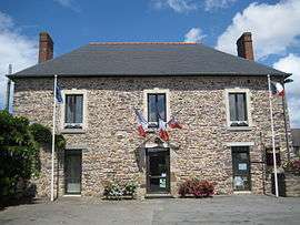 Town hall | |
Location of La Chapelle-Bouëxic 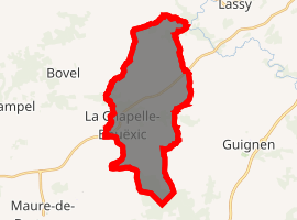
| |
 La Chapelle-Bouëxic  La Chapelle-Bouëxic | |
| Coordinates: 47°55′48″N 1°56′23″W | |
| Country | France |
| Region | Brittany |
| Department | Ille-et-Vilaine |
| Arrondissement | Redon |
| Canton | Guichen |
| Intercommunality | Pays de Maure-de-Bretagne |
| Government | |
| • Mayor (2014–2020) | Roger Morazin |
| Area 1 | 20.66 km2 (7.98 sq mi) |
| Population (2017-01-01)[1] | 1,475 |
| • Density | 71/km2 (180/sq mi) |
| Time zone | UTC+01:00 (CET) |
| • Summer (DST) | UTC+02:00 (CEST) |
| INSEE/Postal code | 35057 /35330 |
| Elevation | 32–112 m (105–367 ft) (avg. 80 m or 260 ft) |
| 1 French Land Register data, which excludes lakes, ponds, glaciers > 1 km2 (0.386 sq mi or 247 acres) and river estuaries. | |
It is located southwest of Rennes between Pont-Péan and Guer.
Population
Inhabitants of La Chapelle-Bouëxic are called Chapellois in French.
| Year | Pop. | ±% |
|---|---|---|
| 1962 | 600 | — |
| 1968 | 656 | +9.3% |
| 1975 | 629 | −4.1% |
| 1982 | 599 | −4.8% |
| 1990 | 670 | +11.9% |
| 1999 | 809 | +20.7% |
| 2008 | 1,276 | +57.7% |
External links
| Wikimedia Commons has media related to La Chapelle-Bouëxic. |
- (in French) Cultural Heritage
| Authority control |
|
|---|
This article is issued from Wikipedia. The text is licensed under Creative Commons - Attribution - Sharealike. Additional terms may apply for the media files.