National Register of Historic Places listings in Platte County, Missouri
This is a list of the National Register of Historic Places listings in Platte County, Missouri, USA.
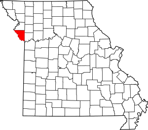
Location of Platte County in Missouri
This is intended to be a complete list of the properties and districts on the National Register of Historic Places in Platte County, Missouri, United States. Latitude and longitude coordinates are provided for many National Register properties and districts; these locations may be seen together in a map.[1]
There are 16 properties and districts listed on the National Register in the county.
- This National Park Service list is complete through NPS recent listings posted August 14, 2020.[2]
Current listings
| [3] | Name on the Register | Image | Date listed[4] | Location | City or town | Description |
|---|---|---|---|---|---|---|
| 1 | Babcock Site | November 15, 1973 (#73001049) |
Address Restricted |
Waldron | ||
| 2 | Benjamin Banneker School |  Benjamin Banneker School |
September 22, 1995 (#95001115) |
31 W. Eighth St. 39°11′34″N 94°41′06″W |
Parkville | |
| 3 | Deister Archeological Site | January 21, 1970 (#70000347) |
Address Restricted |
Kansas City | ||
| 4 | Frederick Krause Mansion |  Frederick Krause Mansion |
May 22, 1978 (#78001672) |
3rd and Harrel Ferrel Dr. 39°22′09″N 94°46′51″W |
Platte City | |
| 5 | Mackay Building |  Mackay Building |
April 6, 1979 (#79001389) |
Park College 39°11′N 94°41′W |
Parkville | |
| 6 | McCormick Distillery |  McCormick Distillery |
April 16, 1974 (#74001090) |
MO JJ 39°23′54″N 94°52′43″W |
Weston | |
| 7 | Missouri District Warehouse |  Missouri District Warehouse |
July 19, 2010 (#10000476) |
357 Main St. 39°22′15″N 94°46′47″W |
Weston | |
| 8 | Platte County Courthouse |  Platte County Courthouse |
January 17, 1979 (#79001390) |
3rd and Main Sts. 39°22′15″N 94°46′47″W |
Platte City | |
| 9 | Pleasant Ridge United Baptist Church |  Pleasant Ridge United Baptist Church |
March 13, 2002 (#02000162) |
Junction of MO P and Woodruff Rd. 39°25′53″N 94°51′21″W |
Weston | |
| 10 | Renner Village Archeological Site | April 16, 1969 (#69000123) |
Renner-Brenner Site Park[5] 39°10′31″N 94°36′54″W |
Riverside | ||
| 11 | Charles Smith Scott Memorial Observatory |  Charles Smith Scott Memorial Observatory |
May 29, 1992 (#92000625) |
8700 River Park Dr. 39°11′24″N 94°40′45″W |
Parkville | Destroyed by fire in 1999. |
| 12 | Sugar Creek Site | December 12, 1973 (#73001050) |
Address Restricted |
Weston | ||
| 13 | TWA Administrative Offices Building | November 6, 2007 (#07001157) |
11500 Ambassador Dr. 39°18′07″N 94°40′54″W |
Kansas City | ||
| 14 | Waddell "A" Truss Bridge | 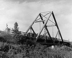 Waddell "A" Truss Bridge |
January 25, 1991 (#90002173) |
English Landing Park, over Rush Cr. 39°11′09″N 94°40′55″W |
Parkville | |
| 15 | Washington Chapel C.M.E. Church |  Washington Chapel C.M.E. Church |
August 31, 1992 (#92001055) |
1137 West St. 39°11′42″N 94°41′09″W |
Parkville | |
| 16 | Weston Historic District | 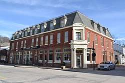 Weston Historic District |
August 21, 1972 (#72000727) |
Roughly bounded by Summit, Rock, Market and Ashley 39°24′47″N 94°54′06″W |
Weston |
See also
References
| Wikimedia Commons has media related to National Register of Historic Places in Platte County, Missouri. |
- The latitude and longitude information provided in this table was derived originally from the National Register Information System, which has been found to be fairly accurate for about 99% of listings. Some locations in this table may have been corrected to current GPS standards.
- "National Register of Historic Places: Weekly List Actions". National Park Service, United States Department of the Interior. Retrieved on August 14, 2020.
- Numbers represent an ordering by significant words. Various colorings, defined here, differentiate National Historic Landmarks and historic districts from other NRHP buildings, structures, sites or objects.
- The eight-digit number below each date is the number assigned to each location in the National Register Information System database, which can be viewed by clicking the number.
- "Ancient Times", City of Riverside, n.d. Accessed 2013-04-30.
| Topics | |
|---|---|
| Lists by state |
|
| Lists by insular areas | |
| Lists by associated state | |
| Other areas | |
| Related | |
| |
Municipalities and communities of Platte County, Missouri, United States | ||
|---|---|---|
| Cities | Map of Missouri highlighting Platte County | |
| Villages | ||
| Townships | ||
| Unincorporated communities | ||
| Footnotes | ‡This populated place also has portions in an adjacent county or counties | |
This article is issued from Wikipedia. The text is licensed under Creative Commons - Attribution - Sharealike. Additional terms may apply for the media files.