National Register of Historic Places listings in Ray County, Missouri
This is a list of the National Register of Historic Places listings in Ray County, Missouri.
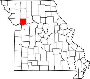
Location of Ray County in Missouri
This is intended to be a complete list of the properties and districts on the National Register of Historic Places in Ray County, Missouri, United States. Latitude and longitude coordinates are provided for many National Register properties and districts; these locations may be seen together in a map.[1]
There are 6 properties and districts listed on the National Register in the county.
- This National Park Service list is complete through NPS recent listings posted August 14, 2020.[2]
Current listings
| [3] | Name on the Register | Image | Date listed[4] | Location | City or town | Description |
|---|---|---|---|---|---|---|
| 1 | Dougherty Auditorium |  Dougherty Auditorium |
September 16, 1982 (#82003158) |
203 W. Main St. 39°16′42″N 93°58′45″W |
Richmond | |
| 2 | Isiah Mansur Farmstead Historic District | August 14, 1998 (#98001063) |
17740 Highway E. 39°24′46″N 93°53′11″W |
Richmond | ||
| 3 | New Hope Primitive Baptist Church |  New Hope Primitive Baptist Church |
November 14, 1980 (#80002393) |
Southwest of Richmond on Old Orrick Rd. 39°14′59″N 94°02′37″W |
Richmond | |
| 4 | Ray County Courthouse |  Ray County Courthouse |
October 11, 1979 (#79001393) |
Off Missouri Routes 10 and 13 39°16′44″N 93°58′37″W |
Richmond | |
| 5 | Ray County Poor Farm |  Ray County Poor Farm |
July 10, 1979 (#79001394) |
W. Royale St. 39°16′22″N 93°59′20″W |
Richmond | |
| 6 | Watkins House |  Watkins House |
February 10, 1983 (#83001036) |
302 S. Camden St. 39°16′36″N 93°58′45″W |
Richmond | Designed by architect George Franklin Barber |
See also
References
| Wikimedia Commons has media related to National Register of Historic Places in Ray County, Missouri. |
- The latitude and longitude information provided in this table was derived originally from the National Register Information System, which has been found to be fairly accurate for about 99% of listings. Some locations in this table may have been corrected to current GPS standards.
- "National Register of Historic Places: Weekly List Actions". National Park Service, United States Department of the Interior. Retrieved on August 14, 2020.
- Numbers represent an ordering by significant words. Various colorings, defined here, differentiate National Historic Landmarks and historic districts from other NRHP buildings, structures, sites or objects.
- The eight-digit number below each date is the number assigned to each location in the National Register Information System database, which can be viewed by clicking the number.
| Topics | |
|---|---|
| Lists by state |
|
| Lists by insular areas | |
| Lists by associated state | |
| Other areas | |
| Related | |
| |
Municipalities and communities of Ray County, Missouri, United States | ||
|---|---|---|
| Cities | Map of Missouri highlighting Ray County | |
| Villages | ||
| Townships | ||
| CDP | ||
| Other unincorporated communities | ||
| Ghost town | ||
| Footnotes | ‡This populated place also has portions in an adjacent county or counties | |
This article is issued from Wikipedia. The text is licensed under Creative Commons - Attribution - Sharealike. Additional terms may apply for the media files.