National Register of Historic Places listings in Butler County, Missouri
This is a list of the National Register of Historic Places listings in Butler County, Missouri.
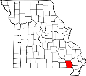
Location of Butler County in Missouri
This is intended to be a complete list of the properties and districts on the National Register of Historic Places in Butler County, Missouri, United States. Latitude and longitude coordinates are provided for many National Register properties and districts; these locations may be seen together in a map.[1]
There are 25 properties and districts listed on the National Register in the county.
- This National Park Service list is complete through NPS recent listings posted August 14, 2020.[2]
Current listings
| [3] | Name on the Register | Image | Date listed[4] | Location | City or town | Description |
|---|---|---|---|---|---|---|
| 1 | Butler County Courthouse |  Butler County Courthouse |
December 1, 1994 (#94001400) |
Public Sq. 36°45′23″N 90°23′32″W |
Poplar Bluff | |
| 2 | Cynthia-Kinzer Historic District | July 21, 2015 (#15000441) |
900-1000 blocks of Cynthia & Kinzer, 918-924 Maud & 838-842 Kinzer Sts. 36°45′40″N 90°24′16″W |
Poplar Bluff | ||
| 3 | Garfield Historic District | October 2, 2017 (#100001686) |
914-916, 915, 921 Garfield St. 36°45′53″N 90°23′50″W |
Poplar Bluff | ||
| 4 | Alfred W. Greer House |  Alfred W. Greer House |
February 12, 1998 (#98000029) |
955 Kinzer St. 36°45′39″N 90°24′10″W |
Poplar Bluff | |
| 5 | Hargrove Pivot Bridge |  Hargrove Pivot Bridge |
October 15, 1985 (#85003234) |
Carries CR 159 over the Black River 36°38′50″N 90°18′00″W |
Poplar Bluff | |
| 6 | Koehler Fortified Archeological Site | December 18, 1970 (#70000323) |
Southeastern quarter of Section 36, Township 23 North, Range 4 East[5] 36°35′39″N 90°34′48″W |
Naylor | Also known as Powers Fort;[6] a cultural center during Mississippian times[5] | |
| 7 | Little Black River Archeological District | April 21, 1975 (#75001064) |
Sharecropper, Harris, and Mackintosh Ridges[5] 36°33′20″N 90°32′40″W |
Naylor | Hundreds of Mississippian archaeological sites, many of them small[5] | |
| 8 | Mark Twain School |  Mark Twain School |
February 5, 1998 (#98000031) |
1012 N. Main St. 36°45′58″N 90°24′04″W |
Poplar Bluff | |
| 9 | J. Herbert Moore House |  J. Herbert Moore House |
February 12, 1998 (#98000032) |
445 N. Eleventh St. 36°45′40″N 90°22′20″W |
Poplar Bluff | |
| 10 | Thomas Moore House |  Thomas Moore House |
February 12, 1998 (#98000033) |
435 Lester St. 36°45′35″N 90°23′39″W |
Poplar Bluff | |
| 11 | Moore-Dalton House |  Moore-Dalton House |
December 1, 1994 (#94001398) |
421 N. Main St. 36°45′35″N 90°23′38″W |
Poplar Bluff | |
| 12 | North Main Street Historic District | July 14, 2011 (#11000440) |
400 block of N. Main St. 36°45′38″N 90°23′40″W |
Poplar Bluff | ||
| 13 | John Archibald Phillips House |  John Archibald Phillips House |
February 12, 1998 (#98000034) |
522 Cherry St. 36°45′14″N 90°23′50″W |
Poplar Bluff | |
| 14 | Poplar Bluff Commercial Historic District | December 1, 1994 (#94001401) |
Roughly, S. Broadway from Cedar St. to Vine St. and Vine from Fifth St. to S. Broadway 36°45′21″N 90°23′40″W |
Poplar Bluff | ||
| 15 | Poplar Bluff Public Library |  Poplar Bluff Public Library |
December 1, 1994 (#94001399) |
318 N. Main St. 36°45′29″N 90°23′32″W |
Poplar Bluff | |
| 16 | Rodgers Theatre Building | 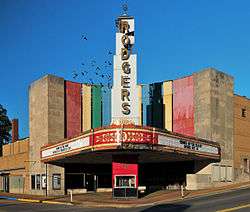 Rodgers Theatre Building |
July 19, 2001 (#01000750) |
204, 214, 216, 218, 220, 222 and 224 N. Broadway 36°45′26″N 90°23′36″W |
Poplar Bluff | |
| 17 | South Sixth Street Historic District | February 12, 1998 (#98000035) |
205-225-303 S. Sixth St. 36°45′21″N 90°23′50″W |
Poplar Bluff | ||
| 18 | St. Louis, Iron Mountain and Southern Railroad Depot |  St. Louis, Iron Mountain and Southern Railroad Depot |
December 1, 1994 (#94001397) |
400 S. Main St. 36°45′13″N 90°23′36″W |
Poplar Bluff | |
| 19 | St. Louis-San Francisco Railroad Depot |  St. Louis-San Francisco Railroad Depot |
December 1, 1994 (#94001396) |
303 Moran St. 36°45′15″N 90°23′43″W |
Poplar Bluff | |
| 20 | Wheatley Public School |  Wheatley Public School |
February 13, 1998 (#98000037) |
921 Garfield St. 36°45′53″N 90°23′49″W |
Poplar Bluff | |
| 21 | Wilborn-Steinberg Site | November 9, 1972 (#72000706) |
Northwestern quarter of the southeastern quarter of Section 9, Township 22 North, Range 5 East[5] 36°34′03″N 90°31′42″W |
Neelyville | ||
| 22 | Williams-Gierth House |  Williams-Gierth House |
November 6, 2012 (#12000909) |
848 Vine St. 36°45′27″N 90°24′04″W |
Poplar Bluff | |
| 23 | Williamson-Kennedy School |  Williamson-Kennedy School |
February 12, 1998 (#98000036) |
614 Lindsay St. 36°45′38″N 90°23′30″W |
Poplar Bluff | |
| 24 | Wright-Dalton-Bell-Anchor Department Store Building |  Wright-Dalton-Bell-Anchor Department Store Building |
April 12, 2006 (#06000247) |
201-205 S. Main 36°45′19″N 90°23′36″W |
Poplar Bluff | |
| 25 | Zehe Building |  Zehe Building |
December 1, 1994 (#94001402) |
203 Poplar St. 36°45′20″N 90°23′32″W |
Poplar Bluff |
See also
References
| Wikimedia Commons has media related to National Register of Historic Places in Butler County, Missouri. |
- The latitude and longitude information provided in this table was derived originally from the National Register Information System, which has been found to be fairly accurate for about 99% of listings. Some locations in this table may have been corrected to current GPS standards.
- "National Register of Historic Places: Weekly List Actions". National Park Service, United States Department of the Interior. Retrieved on August 14, 2020.
- Numbers represent an ordering by significant words. Various colorings, defined here, differentiate National Historic Landmarks and historic districts from other NRHP buildings, structures, sites or objects.
- The eight-digit number below each date is the number assigned to each location in the National Register Information System database, which can be viewed by clicking the number.
- O'Brien, Michael J. Mississippian Community Organization: The Powers Phase in Southeastern Missouri. New York, Boston, Dordrecht, London, and Moscow: Kluwer Academic/Pluwer, 2001, 87.
- "National Register Information System". National Register of Historic Places. National Park Service. July 9, 2010.
| Topics | |
|---|---|
| Lists by state |
|
| Lists by insular areas | |
| Lists by associated state | |
| Other areas | |
| Related | |
| |
Municipalities and communities of Butler County, Missouri, United States | ||
|---|---|---|
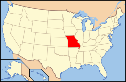
| Cities | Map of Missouri highlighting Butler County | |
| Townships | ||
| CDP | ||
| Other unincorporated communities | ||
| Ghost town | ||
| Footnotes | ‡This populated place also has portions in an adjacent county or counties | |
This article is issued from Wikipedia. The text is licensed under Creative Commons - Attribution - Sharealike. Additional terms may apply for the media files.