Maatsuyker Island
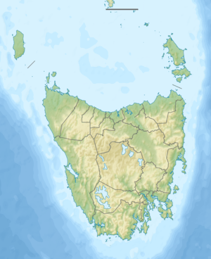
Maatsuyker Island is an island located close to the south coast of Tasmania, Australia. The 186-hectare (0.72 sq mi) island is part of the Maatsuyker Islands Group, and comprises part of the Southwest National Park and the Tasmanian Wilderness World Heritage Site.
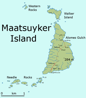 Detailed map of Maatsuyker Island | |
| Etymology | Joan Maetsuicker[1] |
|---|---|
| Geography | |
| Location | South West Tasmania |
| Coordinates | 43°39′00″S 146°16′12″E |
| Archipelago | Maatsuyker Islands Group |
| Adjacent bodies of water | Southern Ocean |
| Area | 186 ha (460 acres) |
| Highest elevation | 284 m (932 ft) |
| Administration | |
Australia | |
| State | Tasmania |
| Region | South West |
| Demographics | |
| Population | A small number of volunteers |
The Maatsuyker Island Lighthouse, the southern-most Australian lighthouse, is located on the southern tip of the island.[2][3] The island is part of the Maatsuyker Island Group Important Bird Area, identified as such by BirdLife International because of its importance as a breeding site for seabirds.[4]
Maatsuyker Island is currently inhabited by volunteers, swapped out every 6 months, the improvements on it are being maintained by the Tasmanian Government and volunteer organisations interested in preserving the history of the island and the lighthouse.
Flora and fauna
The vegetation is dominated by the woody shrub Leptospermum scoparium, or tea tree, which covers most parts of the island, reaching a canopy height of 6 m in sheltered places.
Recorded breeding seabird and wader species are the little penguin (700 pairs), short-tailed shearwater (800,000 pairs), sooty shearwater, fairy prion (5000 pairs), common diving-petrel (10,000 pairs), soft-plumaged petrel, Pacific gull, silver gull and sooty oystercatcher. The swamp antechinus has been recorded.
The island is a haul-out site for the Australian fur seal and a breeding site for the New Zealand fur seal. It is visited by southern elephant seals, which occasionally breed there. Reptiles recorded include the metallic skink, three-lined skink and Tasmanian tree skink.[2]
Traffic
Access to the island has traditionally been by boat, but today helicopters have almost totally taken over this role.[5]
Climate
Because the island is so far south and is influenced by circumpolar weather systems, average temperatures are significantly colder than most of Australia. Maatsuyker Island temperatures are around 10 °C (50 °F) all year with days being cooler and milder. Wind is usually constant.
Due to the high vegetation in patches on the top of the island, it is possible to shelter on the "jeep trail" that runs from the lighthouse to the landing. Several vehicles have been used here over the years, including Suzuki Sierras in the 1980s.
Weather observations have been recorded continuously from the island since 1891.
| Climate data for Maatsuyker Island Lighthouse (1981-2010) | |||||||||||||
|---|---|---|---|---|---|---|---|---|---|---|---|---|---|
| Month | Jan | Feb | Mar | Apr | May | Jun | Jul | Aug | Sep | Oct | Nov | Dec | Year |
| Record high °C (°F) | 31.6 (88.9) |
34.7 (94.5) |
32.4 (90.3) |
31.0 (87.8) |
22.0 (71.6) |
18.8 (65.8) |
17.5 (63.5) |
21.5 (70.7) |
24.6 (76.3) |
27.5 (81.5) |
30.3 (86.5) |
30.4 (86.7) |
34.7 (94.5) |
| Average high °C (°F) | 16.9 (62.4) |
17.4 (63.3) |
16.2 (61.2) |
14.6 (58.3) |
13.0 (55.4) |
11.5 (52.7) |
11.1 (52.0) |
11.3 (52.3) |
12.0 (53.6) |
13.1 (55.6) |
14.4 (57.9) |
15.5 (59.9) |
13.9 (57.0) |
| Average low °C (°F) | 10.9 (51.6) |
11.4 (52.5) |
10.7 (51.3) |
9.7 (49.5) |
8.7 (47.7) |
7.4 (45.3) |
6.9 (44.4) |
6.7 (44.1) |
6.9 (44.4) |
7.4 (45.3) |
8.6 (47.5) |
9.7 (49.5) |
8.8 (47.8) |
| Record low °C (°F) | 3.5 (38.3) |
5.2 (41.4) |
3.3 (37.9) |
0.2 (32.4) |
0.7 (33.3) |
1.5 (34.7) |
−1 (30) |
1.0 (33.8) |
0.8 (33.4) |
−1 (30) |
2.0 (35.6) |
3.2 (37.8) |
−1 (30) |
| Average precipitation mm (inches) | 83.5 (3.29) |
74.6 (2.94) |
82.0 (3.23) |
98.6 (3.88) |
109.7 (4.32) |
123.9 (4.88) |
137.4 (5.41) |
131.6 (5.18) |
118.2 (4.65) |
106.7 (4.20) |
86.7 (3.41) |
89.5 (3.52) |
1,242.7 (48.93) |
| Average precipitation days (≥ 1 mm) | 12.9 | 11.0 | 14.1 | 15.9 | 18.5 | 19.0 | 20.8 | 21.2 | 19.4 | 19.3 | 14.7 | 15.0 | 201.8 |
| Source: Bureau of Meteorology[6] | |||||||||||||
References
- Heeres, J. E. (Editor) (2006). "Abel Janszoon Tasman's Journal of his Discovery of Van Diemen's Land and New Zealand in 1642 with Documents Relating to his Exploration of Australia in 1644...to which are added his Life and Labours, 1898". Project Gutenberg of Australia. Retrieved 9 July 2006.CS1 maint: extra text: authors list (link)
- Brothers, Nigel; Pemberton, David; Pryor, Helen; & Halley, Vanessa. (2001). Tasmania’s Offshore Islands: seabirds and other natural features. Tasmanian Museum and Art Gallery: Hobart. ISBN 0-7246-4816-X
- Small Southern Islands Conservation Management Statement 2002 (PDF), Tasmania Parks and Wildlife Service, 2002, archived from the original (PDF) on 22 August 2006, retrieved 20 July 2006
- BirdLife International. (2011). Important Bird Areas factsheet: Maatsuyker Island Group. Downloaded from http://www.birdlife.org on 09/08/2011.
- "Maatsuyker Island Volunteer Caretaker and Weather Observer Program Information Package" (PDF). Tasmania Parks & Wildlife Service. Retrieved 9 June 2020.
- "Climate Statistics for Maatsuyker Island Lighthouse". Climate statistics for Australian locations. Bureau of Meteorology. Retrieved 23 October 2012.