Macquarie Island
Macquarie Island, a UNESCO World Heritage Site, lies in the Southwestern Pacific Ocean, about halfway between New Zealand and Antarctica.[1] Regionally part of Oceania and politically a part of Tasmania, Australia, since 1900, it became a Tasmanian State Reserve in 1978 and was inscribed on the World Heritage List in 1997.
| Nickname: Macca | |
|---|---|
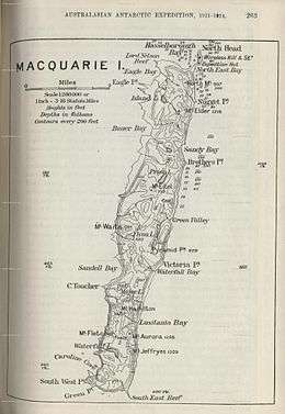 Contour map of Macquarie Island | |
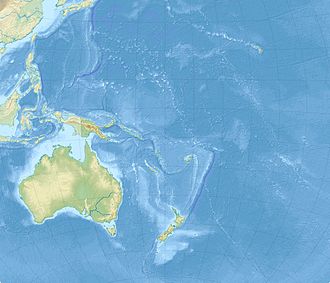 Macquarie Island Location in the Southwestern Pacific Ocean | |
| Geography | |
| Location | Southwestern Pacific Ocean |
| Coordinates | 54°30′0″S 158°57′0″E[1] |
| Area | 128 km2 (49 sq mi) |
| Length | 35 km (21.7 mi) |
| Width | 5 km (3.1 mi) |
| Highest elevation | 410 m (1,350 ft) |
| Highest point |
|
| Administration | |
Australia | |
| State | Tasmania |
| Demographics | |
| Population | No permanent inhabitants |
| Criteria | Natural: vii, viii |
| Reference | 629 |
| Inscription | 1997 (21st session) |
It was a part of Esperance Municipality until 1993, when the municipality was merged with other municipalities to form Huon Valley Council.[2] The island is home to the entire royal penguin population during their annual nesting season. Ecologically, the island is part of the Antipodes Subantarctic Islands tundra ecoregion.
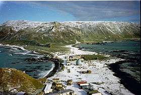
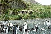
Since 1948 the Australian Antarctic Division (AAD) has maintained a permanent base, the Macquarie Island Station, on the isthmus at the northern end of the island at the foot of Wireless Hill. The population of the base, the island's only human inhabitants, usually varies from 20 to 40 people over the year. A heliport is located near the base.
In September 2016, the Australian Antarctic Division said it would close its research station on the island in 2017.[3] However, shortly afterwards the Australian Government responded to widespread backlash of the decision by announcing funding to upgrade ageing infrastructure and continue existing operations at Macquarie Island.[3]
History
Frederick Hasselborough, an Australian, discovered the uninhabited island on 11 July 1810 when looking for new sealing grounds.[4] He claimed Macquarie Island for Britain and annexed it to the colony of New South Wales in 1810. The island was named for Colonel Lachlan Macquarie, Governor of New South Wales from 1810 to 1821. Hasselborough reported a wreck "of ancient design", which has given rise to speculation that the island may have been visited before by Polynesians or others.[5]
Richard Siddins and his crew were shipwrecked in Hasselborough Bay on 11 June 1812. Joseph Underwood sent the ships Elizabeth and Mary to the island to rescue the remaining crew. When Siddins landed on Macquarie island in 1812, he met the Russian explorer Fabian Gottlieb von Bellingshausen there.
The sealing era on the island lasted from 1810 to 1919, during which time 144 vessel visits are recorded, twelve of which ended in shipwreck.[6] Sealers' relics include iron try pots, casks, hut ruins, graves and inscriptions.
Fabian Gottlieb von Bellingshausen, who explored the area for Alexander I of Russia, produced the first map of Macquarie Island. Bellingshausen landed on the island on 28 November 1820, defined its geographical position and traded his rum and food for Macquarie Island's fauna with the sealers. Between 1810 and 1919, seals and then penguins were hunted almost to the point of extinction.[4] The conditions on the island and the surrounding seas were considered so harsh that a plan to use it as a penal settlement was rejected.[5]
In 1877, the crew of the schooner Bencleugh was shipwrecked on the island for four months; folklore says they came to believe there was hidden treasure on the island.[7] The ship's owner, John Sen Inches Thomson, wrote a book on his sea travels, including his time on the island. The book, written in 1912, was entitled Voyages and Wanderings In Far-off Seas and Lands.[7]
The Tasmanian Government leased the island to Joseph Hatch (1837–1928) between 1902 and 1920 for his oil industry based on harvesting penguins.[8]
.jpg)
Between 1911 and 1914, the island became a base for the Australasian Antarctic Expedition under Sir Douglas Mawson. George Ainsworth operated a meteorological station between 1911 and 1913, followed by Harold Power (1913 to 1914) and by Arthur Tulloch from 1914 until it was shut down in 1915.
In 1933, the authorities declared the island a wildlife sanctuary under the Tasmanian Animals and Birds Protection Act 1928, and in 1972 it was made a State Reserve under the Tasmanian National Parks and Wildlife Act 1970.[9]
On 25 May 1948, the Australian National Antarctic Research Expeditions (ANARE) established its expedition headquarters on Macquarie Island.
The island had status as a biosphere reserve under the Man and the Biosphere Programme from 1977 until its withdrawal from the programme in 2011.[10]
On 5 December 1997, Macquarie Island was inscribed on the UNESCO World Heritage List as a site of major geoconservation significance, being the only place on earth where rocks from the earth's mantle are being actively exposed above sea-level.[9][11]
On 23 December 2004, an earthquake measuring 8.1 on the moment magnitude scale rocked the island but caused no significant damage.[12]
Geoscience Australia issued a Tsunami Inundation Advice for Macquarie Island Station.[13] The paper indicates that a tsunami caused by a local earthquake could occur with no warning possible, and could inundate the isthmus and its existing station. Such a tsunami would likely affect other parts of the coastline and field huts located close to the shore. Such a significant earthquake at Macquarie Island capable of causing such a tsunami is a high risk according to several papers.
In 2018, the Australian Antarctic Division published a map showing the island's buildings with confirmed or suspected asbestos contamination; at least half the island's structures are at least suspected of containing asbestos.[14]
Geography
Macquarie Island is about 34 km (21 mi) long and 5 km (3 mi) wide, with an area of 128 km2 (49 sq mi).[4] The island consists of plateaus at north and south ends, each of 150–200 m (490–660 ft) elevation, joined by a low, narrow isthmus. The high points include Mount Elder on the north-east coastal ridge at 385 m (1,263 ft), and Mounts Hamilton and Fletcher in the south at 410 m (1,345 ft). The island is almost equidistant between the Australian island-state Tasmania, and the Antarctic continent's Anderson Peninsula (about 1,500 km (930 mi) to either point). In addition, Macquarie Island is about 630 km (390 mi) south-west of Auckland Island, and 1,300 km (810 mi) north of the Balleny Islands.
Near Macquarie Island are two small groups of minor islands, the Judge and Clerk Islets (54°21′S 159°01′E), 14 km (9 mi) to the north, 0.2 km2 (49 acres) in area, and the Bishop and Clerk Islets (55°03′S 158°46′E), 34 km (21 mi) to the south, 0.6 km2 (150 acres) in area. The Bishop and Clerk Islets are part of the Australian state of Tasmania and mark the southernmost point of Australia (including islands).
In the 19th century a phantom island named "Emerald Island" was believed to lie south of Macquarie Island.
Geology
Macquarie Island is an exposed portion of the Macquarie Ridge and is located where the Australian Plate meets the Pacific Plate. The island lies close to the edge of the submerged microcontinent of Zealandia, but is not regarded as part of it, as the Macquarie Ridge is oceanic crust rather than continental crust.
It is the only place in the Pacific Ocean where rocks from the mantle are actively exposed. It also is the only oceanic environment with an exposed ophiolite sequence. Due to these unique geological exposures it was made a UNESCO world heritage site in 1997.[11]
Climate
Macquarie Island's climate is moderated by the sea, and all months have an average temperature above freezing although snow is common between June and October and may even occur in Macquarie Island's summer. Its climate is defined as a tundra climate under the Köppen climate classification due to its cool summers.
Average daily maximum temperatures range from 4.9 °C (40.8 °F) in July to 8.8 °C (47.8 °F) in January. Precipitation occurs fairly evenly throughout the year and averages 967.9 mm (38.11 in) annually. Macquarie Island is one of the cloudiest places on Earth with an annual average of only 856 hours of sunshine (similar to Tórshavn in the Faroe Islands), of which comprises 315.4 precipitation days; 289.4 cloudy days, 55.7 snowy days, and 3.5 clear days.[15]
| Climate data for Macquarie Island, Australia | |||||||||||||
|---|---|---|---|---|---|---|---|---|---|---|---|---|---|
| Month | Jan | Feb | Mar | Apr | May | Jun | Jul | Aug | Sep | Oct | Nov | Dec | Year |
| Record high °C (°F) | 13.6 (56.5) |
12.3 (54.1) |
12.6 (54.7) |
12.2 (54.0) |
10.0 (50.0) |
8.7 (47.7) |
8.3 (46.9) |
8.5 (47.3) |
8.6 (47.5) |
10.3 (50.5) |
11.1 (52.0) |
14.4 (57.9) |
14.4 (57.9) |
| Average high °C (°F) | 8.8 (47.8) |
8.7 (47.7) |
8.0 (46.4) |
7.0 (44.6) |
5.9 (42.6) |
5.0 (41.0) |
4.9 (40.8) |
5.1 (41.2) |
5.4 (41.7) |
5.8 (42.4) |
6.5 (43.7) |
7.9 (46.2) |
6.6 (43.9) |
| Daily mean °C (°F) | 7.1 (44.8) |
7.0 (44.6) |
6.4 (43.5) |
5.4 (41.7) |
4.2 (39.6) |
3.3 (37.9) |
3.3 (37.9) |
3.4 (38.1) |
3.5 (38.3) |
3.9 (39.0) |
4.6 (40.3) |
6.1 (43.0) |
4.9 (40.8) |
| Average low °C (°F) | 5.3 (41.5) |
5.3 (41.5) |
4.7 (40.5) |
3.7 (38.7) |
2.5 (36.5) |
1.5 (34.7) |
1.6 (34.9) |
1.6 (34.9) |
1.5 (34.7) |
2.0 (35.6) |
2.7 (36.9) |
4.3 (39.7) |
3.1 (37.6) |
| Record low °C (°F) | 0.6 (33.1) |
−0.6 (30.9) |
−2.3 (27.9) |
−4.5 (23.9) |
−6.8 (19.8) |
−7.0 (19.4) |
−9.4 (15.1) |
−8.9 (16.0) |
−8.7 (16.3) |
−4.6 (23.7) |
−3.9 (25.0) |
−1.7 (28.9) |
−9.4 (15.1) |
| Average precipitation mm (inches) | 86.7 (3.41) |
85.0 (3.35) |
99.7 (3.93) |
93.4 (3.68) |
84.0 (3.31) |
76.6 (3.02) |
73.4 (2.89) |
74.6 (2.94) |
74.6 (2.94) |
77.9 (3.07) |
72.3 (2.85) |
78.5 (3.09) |
976.9 (38.46) |
| Average precipitation days | 25.4 | 24.1 | 27.1 | 27.2 | 28.1 | 26.9 | 27.1 | 27.3 | 26.2 | 26.3 | 25.0 | 24.7 | 315.4 |
| Average relative humidity (%) | 84 | 85 | 86 | 87 | 87 | 87 | 88 | 87 | 85 | 83 | 83 | 83 | 85 |
| Mean monthly sunshine hours | 114.7 | 104.5 | 86.8 | 54.0 | 31.0 | 18.0 | 24.8 | 43.4 | 69.0 | 99.2 | 108.0 | 108.5 | 861.9 |
| Source: Australian Bureau of Meteorology[16] | |||||||||||||
Flora and fauna
The flora has taxonomic affinities with other subantarctic islands, especially those south of New Zealand. Plants rarely grow over 1 m in height, though the tussock-forming grass Poa foliosa can grow up to 2 m tall in sheltered areas. There are over 45 vascular plant species and more than 90 moss species, as well as many liverworts and lichens. Woody plants are absent.
The island has five principal vegetation formations: grassland, herbfield, fen, bog and feldmark. Bog communities include 'featherbed', a deep and spongy peat bog vegetated by grasses and low herbs, with patches of free water.[17] Endemic flora include the cushion plant Azorella macquariensis, the grass Puccinellia macquariensis, and two orchids – Nematoceras dienemum and Nematoceras sulcatum.[18]
Mammals found on the island include subantarctic fur seals, Antarctic fur seals, New Zealand fur seals and southern elephant seals – over 80,000 individuals of this species. Diversities and distributions of cetaceans are less known; southern right whales[19] and orcas are more common followed by other migratory baleen and toothed whales, especially sperm and beaked whales, which prefer deep waters.[20][21] So-called "Upland Seals" once found on Antipodes Islands and Macquarie Island have been claimed by some researchers as a distinct subspecies of fur seals with thicker furs, although it is unclear whether these seals were genetically distinct.[22]
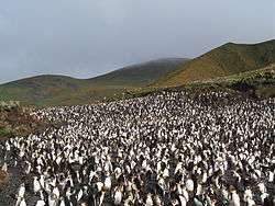
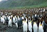
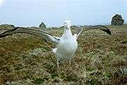
Royal penguins and Macquarie shags are endemic breeders, while king penguins, southern rockhopper penguins and gentoo penguins also breed here in large numbers. The island has been identified by BirdLife International as an Important Bird Area because it supports about 3.5 million breeding seabirds of 13 species.[23]
Ecological balance
The island ecology was affected by the onset of European visits in 1810. The island's fur seals, elephant seals and penguins were killed for fur and blubber. Rats and mice that were inadvertently introduced from the ships prospered due to lack of predators. Cats were subsequently introduced deliberately to keep the rodents from eating human food stores. In about 1870, rabbits and a species of New Zealand rail (wekas) were left on the island by sealers to breed for food.[24] By the 1970s, 130,000 rabbits were causing tremendous damage to vegetation.[25]
The feral cats introduced to the island have had a devastating effect on the native seabird population, with an estimated annual loss of 60,000 seabirds. From 1985, efforts were undertaken to remove the cats. In June 2000, the last of the nearly 2,500 cats were culled in an effort to save the seabirds.[26] Seabird populations responded rapidly,[27] but rats and rabbits population increased after the cats were culled, and continued to cause widespread environmental damage.[26]
The rabbits rapidly multiplied before numbers were reduced to about 10,000 in the early 1980s when myxomatosis was introduced. Rabbit numbers then grew again to over 100,000 by 2006.[28] The rodents feed on young chicks while rabbits nibbling on the grass layer has led to soil erosion and cliff collapses, destroying seabird nests.[26] Large portions of the Macquarie Island bluffs are eroding as a result. In September 2006 a large landslip at Lusitania Bay, on the eastern side of the island, partially destroyed an important penguin breeding colony. Tasmania Parks and Wildlife Service attributed the landslip to a combination of heavy spring rains and severe erosion caused by rabbits.[29]
Research by Australian Antarctic Division scientists, published in the 13 January 2009 issue of the British Ecological Society's Journal of Applied Ecology, suggested that the success of the feral cat eradication program has allowed the rabbit population to increase, damaging the Macquarie Island ecosystem by altering significant areas of island vegetation.[30] However, in a comment published in the same journal other scientists argued that a number of factors (primarily a reduction in the use of the Myxoma virus) were almost certainly involved and the absence of cats may have been relatively minor among them.[31] The original authors examined the issue in a later reply and concluded that the effect of the Myxoma virus use was small and reaffirmed their original position.[32]
On 4 June 2007 a media release by Malcolm Turnbull, Federal Minister for Australia's Environment and Water Resources Board, announced that the Australian and Tasmanian Governments had reached an agreement to jointly fund the eradication of rodent pests, including rabbits, to protect Macquarie Island's World Heritage values.[33] The plan, estimated to cost $24 million Australian dollars, was based on mass baiting the island similar to an eradication program on Campbell Island, New Zealand,[34] to be followed with teams of dogs trained by Steve Austin[35] over a maximum seven-year period.[36] The baiting was expected to inadvertently affect kelp gulls, but greater-than-expected bird deaths caused the program to be suspended. Other species killed by the baits include giant petrels, black ducks and skuas.[37]
In February 2012, The Australian newspaper reported that rabbits, rats and mice had been nearly eradicated from the island.[38]
In April 2012 the hunting teams reported the extermination of 13 rabbits that had survived the 2011 baiting; the last five were found in November 2011, including a lactating doe and four kittens. No fresh rabbit signs were found up to July 2013.[39] On 8 April 2014 Macquarie Island was officially declared pest-free after seven years of conservation efforts.[40] This achievement was the largest successful island pest-eradication program attempted to that date.[41][42]
Gallery
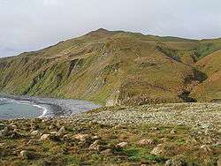
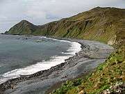 A Macquarie Island beach
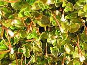 Macquarie Island flora, Epilobium pedunculare
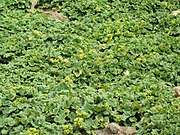 Macquarie Island flora, Stilbocarpa polaris
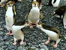 Royal penguins arguing
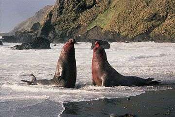 Bull elephant seal fighting
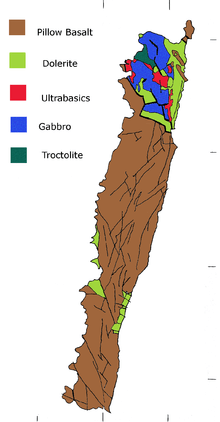 Simplified geological map
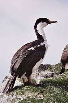 Macquarie Island shag
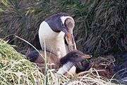
 King penguin Lusitania Bay
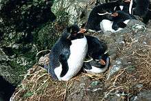
 Green Gorge Hut
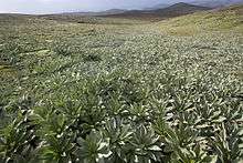 Highland herbfield dominated by Pleurophyllum hookeri
Wildlife sounds
Problems listening to the files? See Wikipedia media help.
See also
- Campbell Macquarie (1812 shipwreck)
- Island restoration
- Lachlan Macquarie
- List of administrative heads of Macquarie Island
- List of Antarctic and subantarctic islands
- List of islands of Tasmania
- Macquarie Fault Zone
- Macquarie Island Marine Park
References
- "Macquarie Island Station". Australian Antarctic Division. Archived from the original on 24 July 2010. Retrieved 16 July 2013.
- Macquarie Island station: a brief history Department of Agriculture, Water and the Environment, Australian Antarctic Division. Retrieved 1 July 2020.
- "Options for a continuing permanent year-round presence on Macquarie Island to be considered". Federal Environment Minister. Retrieved 16 September 2016.
- Scott, Keith (1993). The Australian Geographic book of Antarctica. Terrey Hills, New South Wales: Australian Geographic. p. 14. ISBN 978-1-86276-010-3.
- Macquarie Island: a brief history — Australian Antarctic Division Archived 13 June 2012 at the Wayback Machine. Antarctica.gov.au. Retrieved on 16 July 2013.
- R.K. Headland, Historical Antarctic sealing industry, Scott Polar Research Institute (Cambridge University), 2018, p. 167. ISBN 978-0-901021-26-7, p. 167.
- Inches Thomson, John Sen (1912). Voyages and Wanderings In Far-off Seas and Lands. London, England: Headley Brothers. pp. 139–191.
- "Sinking a Small Fortune: Joseph Hatch and the Oiling Industry" (PDF). Parks and Wildlife Service. Tasmanian Government. Archived (PDF) from the original on 22 August 2017. Retrieved 20 March 2018.
- Parks & Wildlife Service - History of the Reserve Archived 14 March 2011 at the Wayback Machine. Parks.tas.gov.au (24 June 2013). Retrieved 16 July 2013.
- "Biosphere reserves withdrawn from the World Network of Biosphere reserves". Man and the Biosphere Programme. UNESCO. Archived from the original on 11 December 2016. Retrieved 5 November 2016.
- "Macquarie Island". World Heritage List. UNESCO. 1997. Archived from the original on 21 June 2016. Retrieved 8 July 2016.
- "Antarctic expeditioners unscathed by earthquake". ABC News. Australia. 24 December 2004. Archived from the original on 23 December 2007. Retrieved 5 April 2007.
- Geoscience Australia Professional Opinion. January 2014
- "Map 14689: Macquarie Island - Asbestos presence in buildings". data.aad.gov.au (Map). August 2018. Archived (PDF) from the original on 13 January 2019. Retrieved 13 January 2019.
- "Annual snow days sorted in descending order of average occurrence".
- "Climate statistics for Macquarie Island". Bureau of Meteorology. Archived from the original on 23 September 2015. Retrieved 10 November 2015.
- Croft, J. R.; Richardson, M. M. "Macqauarie Island - a report on a short visit". Canberra: Australian National Botanic Gardens. Archived from the original on 28 September 2010. Retrieved 3 August 2010.
- "Plants of Macquarie Island". Australian Plants Society. Archived from the original on 7 July 2011. Retrieved 20 July 2010.
- "Macca Gallery". www.antarctica.gov.au. Archived from the original on 12 August 2016.
- Hoyt E., 2011, Marine Protected Areas for Whales, Dolphins and Porpoises, p. 377, Earthscan, ISBN 9781844077625
- Selkirk P., Seppelt R., Selkirk D., 1990, Subantarctic Macquarie Island - Environment and Biology (Studies in Polar Research), "Appendix 11: Marine Mammals of Macquarie Island" p. 275, Cambridge University Press, ISBN 9780521266338
- Richards, Rhys (1994). ""The upland seal" of the Antipodes and Macquarie Islands: A historian's perspective". Journal of the Royal Society of New Zealand. 24 (3): 289–295. doi:10.1080/03014223.1994.9517473.
- BirdLife International. (2011). Important Bird Areas factsheet: Macquarie Island. Archived 10 July 2007 at WebCite accessed 24 December 2011.
- Parks and Wildlife Service Tasmania (14 July 2015). "Macquarie Island Pest Eradication Project". Archived from the original on 16 March 2017. Retrieved 28 February 2018.
- Macquarie Island faces 'ecosystem meltdown' after conservation efforts backfire Archived 2 February 2017 at the Wayback Machine. The Guardian. accessed on 12 January 2009.
- Squires, Nick (22 January 2007). "Cull upsets island's ecological balance". The Daily Telegraph. London. Archived from the original on 25 December 2017. Retrieved 11 December 2017.
- Brothers, N.; Bone, C. (2008). "The response of burrow-nesting petrels and other vulnerable bird species to vertebrate pest management and climate change on sub-Antarctic Macquarie Island". Papers and Proceedings of the Royal Society of Tasmania. 142: 123–148. doi:10.26749/rstpp.142.1.123.
- "Fears for sub-antarctic island plagued by rabbits". News Online. Australian Broadcasting Corporation. 15 July 2006. Retrieved 5 April 2007.
- "Rabbits blamed for penguin deaths in landslide". News Online. Australian Broadcasting Corporation. 21 October 2006. Retrieved 5 April 2007.
- "Lessons learned from devastating effects of cat eradication on Macquarie Island". Archived from the original on 14 July 2014.
- Dowding, J.E.; Murphy, E.C.; Springer, K.; Peacock, A.J.; Krebs, C.J. (2009). "Cats, rabbits, Myxoma virus, and vegetation on Macquarie Island: a comment on Bergstrom et al. (2009)". Journal of Applied Ecology. 46 (5): 1129–1132. doi:10.1111/j.1365-2664.2009.01690.x.
- Bergstrom, Dana M.; Lucieer, Arko; Kiefer, Kate; Wasley, Jane; Belbin, Lee; Pedersen, Tore K.; Chown, Steven L. (2009). "Management implications of the Macquarie Island trophic cascade revisited: a reply to Dowding et al. (2009)". Journal of Applied Ecology. 46 (5): 1133–1136. doi:10.1111/j.1365-2664.2009.01708.x.
- Turnbull, Malcolm (7 June 2007). "Agreement to eradicate rabbits on Macquarie Island" (PDF) (Press release). Australian Government. Archived from the original (PDF) on 27 September 2007. Retrieved 12 June 2007.
- Darby, Andrew (11 April 2007). "Up against rats, rabbits and costs". The Sydney Morning Herald. Archived from the original on 22 December 2007. Retrieved 11 April 2007.
- Antarctica expedition: Macquarie Island Archived 26 March 2011 at the Wayback Machine, Australian Geographic, 23 March 2011.
- "Parks and Wildlife Service, Tasmania - Plan for the Eradication of Rabbits and Rodents on Macquarie Island". Archived from the original on 12 August 2007.
- Ogilvie, Felicity (23 October 2010). "Bird deaths lead to review of baiting program". ABC News. Australia. Archived from the original on 2 November 2010. Retrieved 17 January 2013.
- Denholm, Matthew (13 February 2012). "Natives thriving since pests were voted off the island". The Australian. Archived from the original on 26 February 2012. Retrieved 27 February 2012.
- "Parks & Wildlife Service - Project News & Updates". parks.tas.gov.au. Archived from the original on 24 April 2013. Retrieved 7 March 2014.
- "Parks & Wildlife Service - News Article". parks.tas.gov.au. Archived from the original on 13 April 2015. Retrieved 8 April 2014.
- "Macquarie Island declared pest free". ABC News. Australia. 7 April 2014. Archived from the original on 8 April 2014.
- South Georgia Declared Rat-Free (The Guardian, 9 May 2018) Accessed 20 July 2020
- General
External links
| Wikimedia Commons has media related to Macquarie Island. |
| Wikisource has the text of the 1911 Encyclopædia Britannica article Macquarie. |
| Wikivoyage has a travel guide for Macquarie Island. |
- Macquarie Island station (Australian Antarctic Division)
- World heritage listing for Macquarie Island
- Macquarie Island oceanic crust
- A picture of Macquarie Island (historical heritage - Remnants of seal hunting)
| Sovereign states |
| .svg.png) | |||||||||
|---|---|---|---|---|---|---|---|---|---|---|---|
Dependencies and other territories |
| ||||||||||
Peri-Antarctic countries and overseas territories | ||
|---|---|---|
"Peri-Antarctic" (meaning "close to the Antarctic") does not include territorial claims in Antarctica itself. | ||