Dover Island (Tasmania)
Dover Island, the third largest island in the Kent Group, is a densely vegetated and unpopulated 295-hectare (730-acre) granite island with steep slopes, located in the Bass Strait, lying off the north-east coast of Tasmania, between the Furneaux Group and Wilsons Promontory in Victoria, Australia.[1]
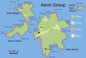 The Dover Island, as located within the Kent Group. | |
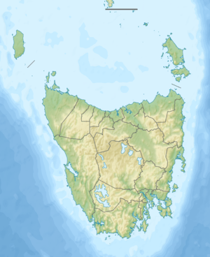 Dover Island Location of the Dover Island in Bass Strait | |
| Geography | |
|---|---|
| Location | Bass Strait |
| Coordinates | 39°28′12″S 147°16′48″E |
| Archipelago | Kent Group |
| Area | 295 ha (730 acres) |
| Administration | |
| State | Tasmania |
| Demographics | |
| Population | unpopulated |
The island is part of the Kent Group National Park, Tasmania's northernmost national park, which was gazetted in 2002. Unlike its companion islands, Deal and Erith, Dover has never been grazed by stock or cleared, so retaining its original cover of native vegetation and almost completely lacking exotic species.[2]
Flora and fauna
Dover is covered by low forest dominated by Drooping Sheoak (Allocasuarina verticillata). Recorded breeding seabird and wader species include little penguin, Pacific gull, and sooty oystercatcher.[3]
References
- "Dover Island (TAS)". Gazetteer of Australia online. Geoscience Australia, Australian Government.
- Parks & Wildlife Service (23 June 2008). "Kent Group National Park - Highlights". Parks & Wildlife Service - Highlights. Department of Primary Industries, Parks, Water and Environment, Tasmania. Archived from the original on 23 March 2018. Retrieved 29 December 2009.
- Brothers, Nigel; Pemberton, David; Pryor, Helen; & Halley, Vanessa. (2001). Tasmania’s Offshore Islands: seabirds and other natural features. Tasmanian Museum and Art Gallery: Hobart. ISBN 0-7246-4816-X
External links
- Parks and Wildlife Service (2005). "Kent Group National Park (Terrestrial Portion) Management Plan 2005". Department of Tourism, Parks, Heritage and the Arts. Hobart: Tasmanian Government. ISBN 0-9751743-4-7.