Curtis Island (Tasmania)
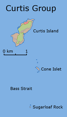
Curtis Island is a granite island, with an area of 150 ha, in south-eastern Australia. It is part of Tasmania’s Curtis Group, lying in northern Bass Strait between the Furneaux Group and Wilsons Promontory in Victoria. It is a nature reserve and has been identified as an Important Bird Area because it supports up to 390,000 breeding pairs of short-tailed shearwaters or Tasmanian muttonbirds.[1]
It was named by lieutenant James Grant, sailing on the Lady Nelson, after Sir Roger Curtis, British governor of the Cape of Good Hope, in December 1800.[2][3][4]
Fauna
As well as the shearwaters, recorded breeding seabird and wader species include little penguin, fairy prion, Pacific gull and sooty oystercatcher. Reptiles present include white-lipped snake, Bougainville's skink, White's skink and metallic skink.[5]
References
- "IBA: Curtis Island". Birdata. Birds Australia. Archived from the original on 6 July 2011. Retrieved 16 June 2011.
- Grant, James (1803). The narrative of a voyage of discovery, performed in His Majesty's vessel the Lady Nelson, of sixty tons burthen: with sliding keels, in the years 1800, 1801, and 1802, to New South Wales. Printed by C. Roworth for T. Egerton. p. 77. ISBN 978-0-7243-0036-5. Retrieved 25 January 2012.
- Lee, Ida (1915), The Logbooks of the Lady Nelson, London: Grafton, p. 328, OL 6580132M, cited in Bird (2006)
- Bird, Eric (12 October 2006). "Place Names on the Coast of Victoria" (PDF). The Australian National Placename Survey (ANPS). Archived from the original (PDF) on 10 February 2011.
- Brothers, Nigel; Pemberton, David; Pryor, Helen; & Halley, Vanessa. (2001). Tasmania’s Offshore Islands: seabirds and other natural features. Tasmanian Museum and Art Gallery: Hobart. ISBN 0-7246-4816-X