Deal Island (Tasmania)
Deal Island, the largest island of the Kent Group, is a 1,576-hectare (3,890-acre) granite island, located in northern Bass Strait, that lies between the Furneaux Group, north-east of Tasmania and Wilsons Promontory in Victoria, Australia.[2]
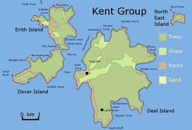 Deal Island is the largest of the Kent Group. | |
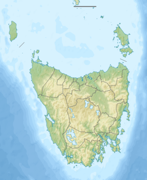 Deal Island Location of Deal Island in Bass Strait | |
| Geography | |
|---|---|
| Location | Bass Strait |
| Coordinates | 39°28′12″S 147°19′12″E |
| Archipelago | Kent Group |
| Area | 1,576 ha (3,890 acres)[1] |
| Administration | |
| State | Tasmania |
Location and features
The island is contained entirely within the 2,374-hectare (5,870-acre) Kent Group National Park, Tasmania’s northernmost national park, gazetted in 2002.[1] In 2004 the national park was extended to include the state waters of the three major islands of the Kent Group marine waters, encapsulating 29,000 hectares (72,000 acres) of marine reserve.[3]
Deal Island is located at the southern end of the 292,800-hectare (724,000-acre) Beagle Commonwealth Marine Reserve, that encloses the Kent Group Marine Reserve and the Hogan and Curtis Island groups.[4]
Deal Island has been extensively modified in the past by human activity in the construction of facilities and the vegetation clearance and regular firing associated with grazing livestock. It has a lighthouse, airstrip (closed), roads, jetty, two houses, a dam and a museum.[5]
Lighthouse
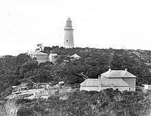
Deal Island has the highest lighthouse in the Southern Hemisphere,[6] standing 305 metres (1,001 ft) above sea level and was sometimes visible at night from Wilson's Promontory, 80 kilometres (50 mi) away. The lighthouse was built in 1848 and deactivated in 1992. While active, the height caused problems with visibility in low cloud conditions. Management and conservation is under the control of the Tasmania Parks and Wildlife Service.[6]
Aircraft crash
On 26 April 1943 during World War II an RAAF A25 Airspeed Oxford aircraft crashed on the island, killing all four crewmen. The aircraft wreck and their graves are about 15 metres (49 ft) apart at the bottom of a cliff. The bodies have since been disinterred and buried at Springvale, Victoria.[7] Eyewitness accounts say the plane flew low over a ship which was actually a wreck, and then failed to regain enough height before hitting the cliff.
Fauna
Recorded breeding seabird and wader species include little penguin, Pacific gull, and sooty oystercatcher. Mammals found on the island are the red-necked wallaby, common brushtail possum, southern brown bandicoot, fur seals and the introduced European rabbit. Reptiles present include the metallic skink, Bougainville's skink, White's skink and the white-lipped snake.[5]
Climate
| Month | Jan | Feb | Mar | Apr | May | Jun | Jul | Aug | Sep | Oct | Nov | Dec | Year |
|---|---|---|---|---|---|---|---|---|---|---|---|---|---|
| Record high °C (°F) | 35.8 (96.4) |
32.8 (91.0) |
31.3 (88.3) |
25.5 (77.9) |
23.2 (73.8) |
18.2 (64.8) |
17.2 (63.0) |
20.4 (68.7) |
24.9 (76.8) |
26.0 (78.8) |
33.6 (92.5) |
30.2 (86.4) |
35.8 (96.4) |
| Average high °C (°F) | 20.2 (68.4) |
20.5 (68.9) |
19.4 (66.9) |
17.6 (63.7) |
15.6 (60.1) |
13.5 (56.3) |
12.7 (54.9) |
12.8 (55.0) |
13.7 (56.7) |
15.4 (59.7) |
16.8 (62.2) |
18.3 (64.9) |
16.4 (61.5) |
| Average low °C (°F) | 14.1 (57.4) |
14.6 (58.3) |
14.2 (57.6) |
12.8 (55.0) |
11.5 (52.7) |
9.7 (49.5) |
8.5 (47.3) |
8.2 (46.8) |
8.9 (48.0) |
9.8 (49.6) |
11.2 (52.2) |
12.6 (54.7) |
11.3 (52.3) |
| Record low °C (°F) | 4.9 (40.8) |
8.0 (46.4) |
3.8 (38.8) |
3.3 (37.9) |
0.4 (32.7) |
−0.5 (31.1) |
−0.5 (31.1) |
−5.5 (22.1) |
−0.2 (31.6) |
5.0 (41.0) |
−4.0 (24.8) |
2.5 (36.5) |
−5.5 (22.1) |
| Average precipitation mm (inches) | 40.7 (1.60) |
38.7 (1.52) |
52.3 (2.06) |
61.1 (2.41) |
73.6 (2.90) |
78.5 (3.09) |
78.5 (3.09) |
73.3 (2.89) |
61.4 (2.42) |
60.8 (2.39) |
50.8 (2.00) |
49.6 (1.95) |
718.8 (28.30) |
| Average precipitation days (≥ 0.2 mm) | 8.2 | 7.4 | 9.7 | 12.4 | 14.8 | 16.0 | 16.9 | 16.4 | 14.5 | 13.3 | 11.5 | 10.0 | 151.1 |
| Source: Bureau of Meteorology[8] | |||||||||||||
References
- "Kent Group National Park". Parks & Wildlife Service, Department of Primary Industries, Parks, Water and Environment. Tasmanian Government. 14 October 2010. Archived from the original on 26 March 2016. Retrieved 3 July 2016.
- "Deal Island (TAS)". Gazetteer of Australia online. Geoscience Australia, Australian Government.
- "Kent Group Marine Reserve". Parks & Wildlife Service, Department of Primary Industries, Parks, Water and Environment. Tasmanian Government. 19 June 2014. Retrieved 3 July 2016.
- "Beagle Commonwealth Marine Reserve". Marine reserves. Department of the Environment, Australian Government. Retrieved 4 July 2016.
- Brothers, Nigel; Pemberton, David; Pryor, Helen; & Halley, Vanessa. (2001). Tasmania’s Offshore Islands: seabirds and other natural features. Tasmanian Museum and Art Gallery: Hobart. ISBN 0-7246-4816-X
- "Deal Island lighthouse". Lighthouses of Tasmania. Lighthouses of Australia Inc.
- "Picking up the wrecked pieces". The Age Online. Fairfax Media. Retrieved 11 April 2015.
- "Climate Statistics for Deal Island". Climate statistics for Australian locations. Bureau of Meteorology. Retrieved 23 October 2012.