Interstate 530
Interstate 530 (I-530) in Arkansas is a spur route of the Interstate highway system, traveling 46.65 miles (75.08 km) from Pine Bluff north-northwest to Little Rock, at an interchange of I-30/I-440/US 65/US 67/US 167.[3] The highway also travels through the cities of Redfield and White Hall. In the future, I-530 will connect I-69 and I-30. A short section near the future I-69 alignment has been signed as Arkansas 530.
| ||||
|---|---|---|---|---|
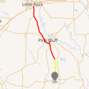
I-530/SR 530 highlighted in red, future sections in yellow | ||||
| Route information | ||||
| Auxiliary route of I-30 | ||||
| Maintained by ArDOT | ||||
| Length | 46.65 mi[1] (75.08 km) | |||
| Existed | August 2, 1999[2]–present | |||
| Major junctions | ||||
| South end | ||||
| ||||
| North end | ||||
| Location | ||||
| Counties | Jefferson, Grant, Saline, Pulaski | |||
| Highway system | ||||
| ||||
.svg.png)
Route description
The route begins at a high volume intersection with I-30/I-440/US 65/US 67/US 167 in southeast Little Rock.[4] This intersection handles over 100,000 vehicles per day on average.[5] I-530 runs south with US 65 and US 167 through marshland, entering Saline County briefly to split with US 167 south.[6] Returning to Pulaski County, I-530 has an exit at Hensley (which also connects to Highway 365) before entering Jefferson County.[4]
Interstate 530 continues south, passing through forested land and clear cut areas, also running parallel to AR 365. I-530 intersects Highway 46 in Redfield before entering White Hall.[7] After an intersection with Arkansas Highway 256, the route runs south to serve as the eastern terminus for US 270. This exit also contains Arkansas Highway 365 Spur eastbound to White Hall. Continuing south to Pine Bluff, I-530 serves as a beltway around the city. I-530 skirts the city to the southwest, including exits for West 19th Street, US 79B, and US 63B.
The Interstate ends at a very large junction with US 63/US 65/US 65B/US 79/US 425/AR 190, after which the roadway continues south as US 65/US 425 toward Dumas.
This Interstate highway is unusual in that its exit number increase south rather than north. However, the standard for spurs is to increase from the beginning at the parent.
US 167 intersection
The US Route 167 junction (Exit 10) can only be accessed by southbound I-530 but not northbound I-530. There existed a median crossover to access US 167 South from I-530 North, but this was removed due to numerous severe and fatal accidents at the crossover. Northbound I-530 traffic must now use the Bingham Road (Exit 9) exit and cross the overpass to I-530 South.
I-530 State Scenic Byway
Interstate 530 is designated as one of ten Arkansas Scenic Byways for 15 miles (24 km) from AR 256 northwest of White Hall to U.S. Route 65 in southern Pine Bluff.[8] The route passes over Bayou Bartholomew and the Mississippi Alluvial Plain. The southern portion was formerly a wetland preserve, but now the land is being developed.
History
The current route was formerly designated as U.S. Highway 65. Today, I-530 and US 65 run concurrently as a four-lane, limited-access spur route. The route formally gained the I-530 designation after a full interstate-grade bypass of Pine Bluff (known locally as the Wiley Branton Highway) replaced a segment of US 65 through Pine Bluff that contains at-grade intersections. This segment (known locally as the Martha Mitchell Expressway) was re-designated U.S. 65 Business; U.S. 65 was rerouted to the bypass before gaining the I-530 co-designation.
Exit list
| County | Location | mi[3] | km | Exit | Destinations | Notes |
|---|---|---|---|---|---|---|
| Pulaski | Little Rock | 0.00 | 0.00 | Northern terminus; north end of US 65 / US 167 overlap; I-30 exit 138 westbound | ||
| 1A | Northbound entrance feeds directly to I-30 east; signed as exit 138 southbound; I-440 exit 138B westbound | |||||
| 1B | Northbound exit and southbound entrance; I-30 exit 138B eastbound | |||||
| | 2.71 | 4.36 | 3 | |||
| | 6.57 | 10.57 | 7 | 145th Street / Pratt Road | ||
| | 8.77 | 14.11 | 9 | Bingham Road | ||
| Saline | | 9.96 | 16.03 | 10 | South end of US 167 overlap; no northbound exit | |
| | 11.63 | 18.72 | 12 | Woodson | ||
| Pulaski | | 14.96 | 24.08 | 15 | Hensley | |
| Jefferson | | 19.94 | 32.09 | 20 | ||
| | 23.69 | 38.13 | 24 | Jefferson, National Center for Toxicological Research | ||
| | 26.53 | 42.70 | 27 | |||
| | 29.78 | 47.93 | 30 | |||
| White Hall | 31.74 | 51.08 | 32 | |||
| 33.67 | 54.19 | 34 | ||||
| 35.14– 35.33 | 56.55– 56.86 | 35 | ||||
| | 36.57 | 58.85 | 36 | Princeton Pike | ||
| | 37.53 | 60.40 | 37 | |||
| Pine Bluff | 39.46 | 63.50 | 39 | North end of US 79 overlap | ||
| 40.85 | 65.74 | 41 | Old Warren Road | |||
| 41.97 | 67.54 | 42 | Hazel Street | |||
| 42.99 | 69.19 | 43 | North end of US 63 overlap | |||
| | 43.87– 44.03 | 70.60– 70.86 | 44 | Future I-530 south | ||
| Pine Bluff | 46.32 | 74.54 | 46 | south end of US 63 / US 79 overlap | ||
| 46.63 | 75.04 | Continuation south; Temporary Southern Terminus of I-530. | ||||
1.000 mi = 1.609 km; 1.000 km = 0.621 mi
| ||||||
Future
Arkansas Highway 530
| |
|---|---|
| Future I-530 SIU 28 of Interstate 69 | |
_map.svg.png) | |
| Route information | |
| Maintained by ADOT | |
| Length | 1.00 mi (1.61 km) |
| Existed | October 22, 1986–present |
| Northern Section | |
| North end | |
| Major junctions | |
| South end | |
| Southern Section | |
| North end | |
| Major junctions | |
| South end | |
| Highway system | |

A planned extension of the route pushes the Interstate south to U.S. Route 278 in Wilmar. The first segment of the extension from US 278 north to Arkansas 35, opened as a two-lane expressway designated Arkansas Highway 530 on June 6, 2006.[9] This extension is intended to connect to the proposed southern extension of Interstate 69; U.S. 278 at Wilmar also provides four-lane access to the future I-530 from the larger cities of Warren and Monticello, thus allowing both to champion its completion. Though sufficient right-of-way was provided and grading done for interchanges at both ends as well as two additional lanes, this segment presently has stop signs at both ends and an intersection with Bradley County Road 96/Barkada Road; it is otherwise a two-lane expressway in between.
The second segment of the extension opened in September 2013. It connects the Interstate 530 interchange in Pine Bluff with State Highway 11 in Lincoln County and is 18 miles in length. Currently the segment is 2 lanes until further funding is available.[10]
The remaining segments between AR 35 and Pine Bluff will also be built as a partial two-lane freeway, similar to the existing AR 35-U.S. 278 segment and Pine Bluff intersection to AR 114 segment. Initially, the only full interchange will be with the present I-530 at Pine Bluff; grade crossings will be built at other planned interchanges, but the stretches between grade crossings will be true two-lane expressways with grade separations and service roads where needed. The route includes sufficient right-of-way to build interchanges and two additional lanes later; the Pine Bluff interchange will be a full freeway-to-freeway facility designed for the future four-lane freeway. As of August 18, 2015, the next segment - AR 114 to AR 11 was open to traffic. Eventually, the route will connect Pine Bluff and Little Rock to Interstate 69 in Arkansas.
Major intersections
| County | Location | mi | km | Destinations | Notes | |||
|---|---|---|---|---|---|---|---|---|
| Jefferson | | I-530 exit 44 | ||||||
| Cleveland |
No major junctions | |||||||
| Lincoln | | |||||||
| | ||||||||
| | Interchange; Temporary southern terminus | |||||||
| Gap in route | ||||||||
| Drew | | Temporary northern terminus | ||||||
| | Temporary southern terminus | |||||||
| | ||||||||
| 1.000 mi = 1.609 km; 1.000 km = 0.621 mi | ||||||||
References
- "Route Log - Auxiliary Routes of the Eisenhower National System Of Interstate and Defense Highways - Table 2". Federal Highway Administration. Retrieved 5 October 2014.
- "The 90s". Historical review volume two: Arkansas State Highway Commission and Arkansas State Highway and Transportation Department, 1913-2003. Little Rock, Arkansas: Arkansas State Highway and Transportation Department. April 2004. p. 157.
- "[Arkansas] State Highways 2009 (Database)." April 2010. AHTD: Planning and Research Division. Database. Archived 2011-07-07 at the Wayback Machine Retrieved May 25, 2011.
- General Highway Map (PDF) (Map) (Pulaski County ed.). Arkansas State Highway and Transportation Department. Retrieved May 31, 2011.
- Average Daily Traffic (ADT) Map, Little Rock, Arkansas (PDF) (Map) (2010 ed.). Arkansas State Highway and Transportation Department. Retrieved May 31, 2011.
- General Highway Map (PDF) (Map) (Saline County ed.). Arkansas State Highway and Transportation Department. Retrieved May 31, 2011.
- General Highway Map (PDF) (Map) (Jefferson County ed.). Arkansas State Highway and Transportation Department. Retrieved May 31, 2011.
- "Interstate 530 State Scenic Byway." Arkansas Department of Parks and Tourism. Drive Profile. Retrieved June 26, 2010.
- New Arkansas Highway To Be Dedicated | todaysthv.com
- "New State Highway 530 opens". Pine Bluff Commercial.
1Future 2Cancelled | ||