Interstate 630
Interstate 630 (I-630) in Arkansas is an east–west connector within Little Rock. It is also known as the Wilbur D. Mills Freeway and starts at I-30, U.S. Route 65, U.S. 67 and U.S. 167 traveling west through downtown Little Rock to I-430 and Chenal Parkway.[2][3]
| ||||
|---|---|---|---|---|
| Eisenhower Memorial Highway | ||||
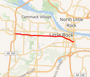
I-630 highlighted in red | ||||
| Route information | ||||
| Auxiliary route of I-30 | ||||
| Maintained by ArDOT | ||||
| Length | 7.400 mi[1] (11.909 km) | |||
| Existed | September 30, 1985[2]–present | |||
| Major junctions | ||||
| West end | ||||
| ||||
| East end | ||||
| Location | ||||
| Counties | Pulaski | |||
| Highway system | ||||
| ||||
.svg.png)
History
The project was first conceived in the 1930s, and was first planned by the Pulaski County Planning Board in their 1941 report.[4] After the having many higher powers denying their plans construction was started by the city of Little Rock in the 1960s as the east–west Expressway or 8th Street Expressway and was not originally an Interstate or an Arkansas state highway.[2] In the 1970s, U.S. Rep. Wilbur D. Mills (D-AR) was responsible for the route's addition to the Interstate system by rounding down the mileage allocations of all other states, then adding the rounding differences to Arkansas's total; this kept the total nationwide allocation within the original limit of 42,500 miles (68,400 km).[2]
After it was added to the Interstate system, Little Rock initially renamed it for Mills; however, when the Arkansas State Highway Department (AHTD) formally brought it into the state highway system as required by Arkansas law, they removed the name, as their policy at the time prohibited the naming of state highways after individuals. The AHTD later changed its policy and re-adopted the Mills name early in the new millennium. As of Autumn, 2019, the highway is now named "Gold Star Families Memorial Highway."
The highway connects burgeoning West Little Rock to the downtown core.[5] It feeds into I-430, a north–south route which serves western Little Rock.[2]
Exit list
The entire route is in Little Rock, Pulaski County.
| mi[1] | km | Exit | Destinations | Notes | |
|---|---|---|---|---|---|
| 0.00 | 0.00 | 139 | Eastbound exit and westbound entrance; eastern terminus and signed as exits 139A (east) and 139B (west); exit nos. correspond to I-30 | ||
| 1 | 15th Street | Eastbound left exit and westbound entrance | |||
| 0.46 | 0.74 | 1A | Main Street, Center Street | ||
| 0.74 | 1.19 | 1B | US 70 not signed | ||
| 1.10 | 1.77 | 2A | Chester Street | ||
| 1.45 | 2.33 | 2B | Dr. Martin Luther King Jr. Drive, Marshall Street | ||
| 2.43 | 3.91 | 3A | Woodrow Street | ||
| 3.80 | 6.12 | 3B | Pine Street / Cedar Street | ||
| 5.00 | 8.05 | 4 | Fair Park Boulevard | ||
| 5.48 | 8.82 | 5 | University Avenue | Signed as exits 5A (north) and 5B (south) westbound; second westbound entrance from McKinley Avenue | |
| 5.80 | 9.33 | 6A | Rodney Parham Road / Mississippi Avenue | ||
| 6.25 | 10.06 | 6B | Barrow Road | ||
| 6.82 | 10.98 | 7 | Baptist Health | Eastbound access via Chenal Parkway | |
| 7.40 | 11.91 | 8 | Signed as exits 8A (north) and 8B (south); eastbound access via Chenal Parkway; I-430 exit 6 | ||
| 8C | Shackleford Road / Markham Street / Kanis Road | Eastbound access via Chenal Parkway | |||
| – | Chenal Parkway | Continuation west | |||
| 1.000 mi = 1.609 km; 1.000 km = 0.621 mi | |||||
References
- Planning and Research Division (2010). "Arkansas Road Log Database". Arkansas State Highway and Transportation Department. Archived from the original (Database) on June 23, 2011. Retrieved June 9, 2011.
- Bill Stanton, ed. (Winter 1985). "Final Section of I-630 opens in Little Rock" (PDF). Arkansas Highways. Little Rock, Arkansas: Arkansas State Highway and Transportation Department. 31: 8. Retrieved October 24, 2011.
- Route and Section Map, Pulaski County Supplemental Sheet (PDF) (Map). Cartography by Planning and Research Division. Arkansas State Highway and Transportation Department. Retrieved October 24, 2011.
- Bill Stanton, ed. (1985). "I-630 History: "A dream becomes a reality"". Arkansas Highways (PDF). 31 (Winter ed.). Little Rock, Arkansas: Arkansas State Highway and Transportation Department. p. 10. Retrieved October 24, 2011.
- https://arktimes.com/news/cover-stories/2011/01/26/wilbur-mills-wall
1Future 2Cancelled | ||