Administrative divisions of American Samoa
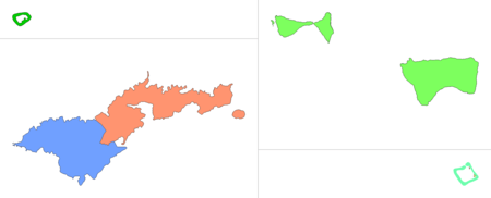
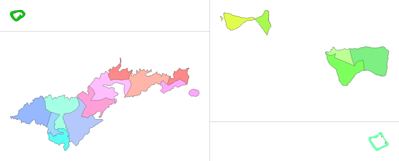
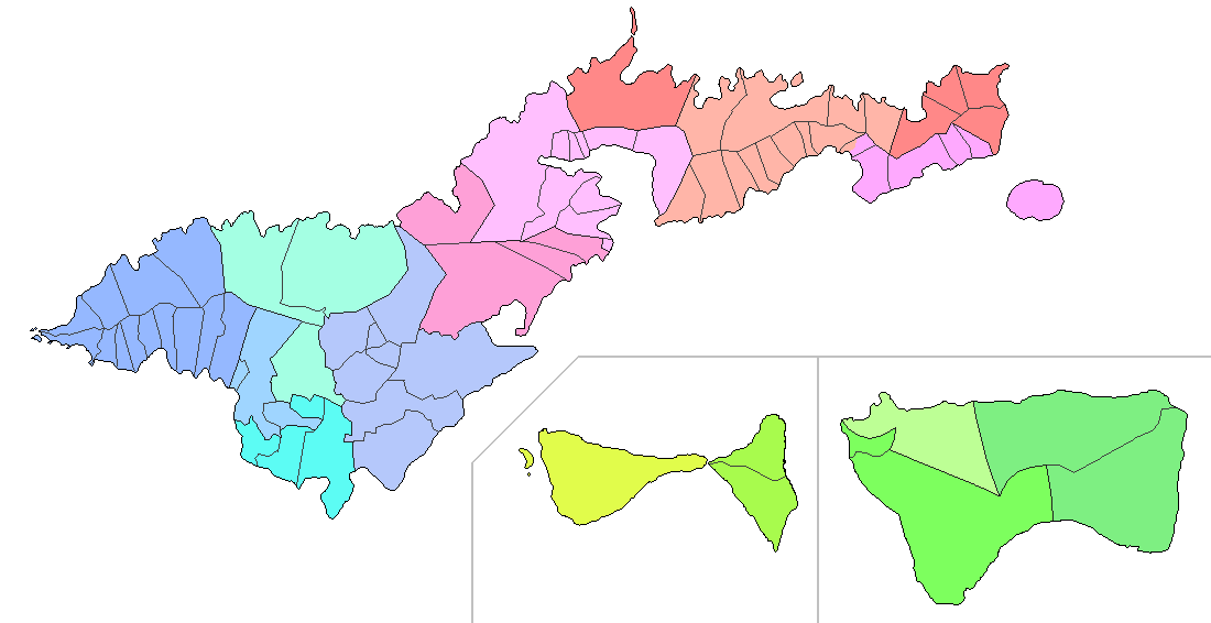
American Samoa is administratively divided into three districts (Western, Eastern and Manu‘a) and two unorganized atolls (Swains Island and Rose Atoll). The districts are subdivided into 15 counties,[lower-alpha 1] which are composed of 76 villages.[9]
| Districts and unorganized atolls of American Samoa | |
|---|---|
| Category | County equivalent |
| Location | American Samoa |
| Number | 3 districts 2 unorganized atolls |
| Populations | 31,329 (Western District) – 0 (Rose Atoll) |
| Areas | 27.51 sq mi (71.25 km2) (Western District) – 0.03 sq mi (0.08 km2) (Rose Atoll) |
| Government | Local government |
| Subdivisions | Counties and villages |
For statistical purposes, the United States Census Bureau counts the three districts and two unorganized atolls as five county equivalents, while treating the actual counties as "minor civil divisions".[10]
American Samoa has only one U.S. zip code: 96799.[11]
Divisions
 |
|---|
| This article is part of a series on the politics and government of American Samoa |
|
|
| island/atoll | district | county | villages[9] |
|---|---|---|---|
| Tutuila | Western | Lealataua | Fagamalo, Maloata, Fagali‘i, Poloa, Amanave, Failolo, Agugulu, Utumea West, Se‘etaga, Nua, Afao, Asili, Amaluia |
| Fofo[lower-alpha 1] | Leone, Auma, Puapua | ||
| Leasina | Aasu,[lower-alpha 2] Aoloau, Malaeloa/Aitulagi | ||
| Tualatai | Malaeloa/Ituau, Futiga, Taputimu, Vailoatai | ||
| Tualauta | Vaitogi, Ili‘ili, Tafuna,[lower-alpha 3] Pava‘ia‘i, Faleniu, Mapusagafou, Mesepa, Malaeimi[lower-alpha 4] | ||
| Eastern | Itu‘au | Fagasa, Nu‘uuli,[lower-alpha 5] Faganeanea, Matu‘u | |
| Ma‘oputasi | Fatumafuti, Faga‘alu, Utulei, Fagatogo, Pago Pago, Satala, Anua, Atu‘u, Leloaloa, Aua | ||
| Vaifanua | Vatia, Alao, Tula, Onenoa, Aoa | ||
| Sua | Sa‘ilele, Masausi, Masefau, Afono, Lauli‘i, Aumi, Alega, Avaio, Auto, Amaua, Utusia, Faga‘itua, Pagai[lower-alpha 6] | ||
| Sa‘ole | Pagai,[lower-alpha 6] Alofau, Amouli, Auasi, Utumea East | ||
| Aunu‘u | Aunu‘u | ||
| Ofu | Manu‘a | Ofu | Ofu |
| Olosega | Olosega | Olosega, Sili | |
| Ta‘ū | Ta‘ū | Si‘ufaga, Luma | |
| Faleasao | Faleasao | ||
| Fitiuta | Maia, Leusoali‘i | ||
| Swains | — | — | Taulaga, Etena (abandoned)[12] |
| Rose | — | — | — |
Maps
 Sa‘ole
Ta‘ū
Faleasao
Fitiuta
Sua
╱
╲
Ma‘oputasi
Itu‘au
Tualauta
Fofo
|
| Counties of American Samoa[lower-alpha 1][13] |
 Maloata
Fagali‘i
Utumea
West Se‘etaga
Nua
Auma
Puapua
Malaeloa/
Ituau Vailoatai
Mesepa
Malaeimi
Faganeanea
Matu‘u
Onenoa
Masausi
Masefau
Avaio
Utusia
Auasi
Utumea
East Si‘ufaga
|
| Villages of American Samoa[13] |
Statistics
The statistics below are from the 2010 census.
-
island/atoll[8][9] population land area number % sq mi km2 % Tutuila 53,923 97.13% 52.62 136.29 68.82% Aunu‘u 436 0.79% 0.58 1.50 0.76% Ofu 176 0.32% 2.84 7.36 3.71% Olosega 177 0.32% 2.04 5.28 2.67% Ta‘ū 790 1.42% 17.41 45.09 22.77% Swains 17 0.03% 0.94 2.43 1.23% Rose 0 0.00% 0.03 0.08 0.04% American Samoa 55,519 100.00% 76.46 198.03 100.00% district[8] population land area number % sq mi km2 % Western[lower-alpha 2][lower-alpha 3][lower-alpha 4][lower-alpha 5] 31,329 56.43% 27.51 71.25 35.98% Eastern[lower-alpha 2][lower-alpha 3][lower-alpha 4][lower-alpha 5] 23,030 41.48% 25.69 66.54 33.60% Manu‘a 1,143 2.06% 22.29 57.73 29.15% county[8] population land area number % sq mi km2 % Lealataua[lower-alpha 7] 1,965 3.54% 6.98 18.08 9.13% Fofo[lower-alpha 8] 3,138 5.65% 1.99 5.15 2.60% Leasina[lower-alpha 2] 1,807 3.25% 7.03 18.21 9.19% Tualatai 3,561 6.41% 2.61 6.76 3.41% Tualauta[lower-alpha 3][lower-alpha 4][lower-alpha 5] 20,858 37.57% 8.89 23.02 11.63% Itu‘au[lower-alpha 2][lower-alpha 3][lower-alpha 4][lower-alpha 5] 4,676 8.42% 5.56 14.40 7.27% Ma‘oputasi 10,299 18.55% 6.63 17.17 8.67% Vaifanua 2,545 4.58% 4.60 11.91 6.02% Sua 3,323 5.99% 6.60 17.09 8.63% Sa‘ole 2,187 3.94% 2.31 5.98 3.02% Ofu 176 0.32% 2.84 7.36 3.71% Olosega 177 0.32% 2.04 5.28 2.67% Ta‘ū 358 0.64% 6.13 15.88 8.02% Faleasao 162 0.29% 2.68 6.94 3.51% Fitiuta 270 0.49% 8.60 22.27 11.25% -
village[9] population land area number % sq mi km2 % Fagamalo 47 0.08% 1.39 3.60 1.82% Maloata 8 0.01% 1.21 3.13 1.58% Fagali‘i 247 0.44% 0.60 1.55 0.78% Poloa 193 0.35% 0.32 0.83 0.42% Amanave 250 0.45% 0.30 0.78 0.39% Failolo 108 0.19% 0.25 0.65 0.33% Agugulu 51 0.09% 0.15 0.39 0.20% Utumea West 53 0.10% 0.26 0.67 0.34% Se‘etaga 299 0.54% 0.27 0.70 0.35% Nua 141 0.25% 0.37 0.96 0.48% Afao 182 0.33% 0.54 1.40 0.71% Asili 224 0.40% 0.54 1.40 0.71% Amaluia 162 0.29% 0.78 2.02 1.02% Leone 1,919 3.46% 1.49 3.86 1.95% Auma 254 0.46% 0.13 0.34 0.17% Puapua 965 1.74% 0.37 0.96 0.48% Aasu[lower-alpha 2] 494 0.89% 3.44 8.91 4.50% Aoloau 615 1.11% 2.24 5.80 2.93% Malaeloa/Aitulagi 698 1.26% 1.39 3.60 1.82% Malaeloa/Ituau 550 0.99% 0.23 0.60 0.30% Futiga 723 1.30% 1.35 3.50 1.77% Taputimu 841 1.51% 0.62 1.61 0.81% Vailoatai 1,447 2.61% 0.41 1.06 0.54% Vaitogi 1,959 3.53% 1.38 3.57 1.80% Ili‘ili 3,195 5.75% 1.39 3.60 1.82% Tafuna[lower-alpha 3] 7,945 14.31% 2.49 6.45 3.26% Pava‘ia‘i 2,450 4.41% 0.73 1.89 0.95% Faleniu 1,898 3.42% 0.25 0.65 0.33% Mapusagafou 1,126 2.03% 0.80 2.07 1.05% Mesepa 444 0.80% 0.11 0.28 0.14% Malaeimi[lower-alpha 4] 1,182 2.13% 1.65 4.27 2.16% Fagasa 831 1.50% 1.65 4.27 2.16% Nu‘uuli[lower-alpha 5] 3,955 7.12% 2.97 7.69 3.88% Faganeanea 150 0.27% 0.53 1.37 0.69% Matu‘u 399 0.72% 0.47 1.22 0.61% Fatumafuti 113 0.20% 0.04 0.10 0.05% Faga‘alu 910 1.64% 0.45 1.17 0.59% Utulei 684 1.23% 0.33 0.85 0.43% Fagatogo 1,737 3.13% 0.71 1.84 0.93% Pago Pago 3,656 6.59% 3.43 8.88 4.49% Satala 297 0.53% 0.15 0.39 0.20% Anua 18 0.03% 0.07 0.18 0.09% Atu‘u 359 0.65% 0.06 0.16 0.08% Leloaloa 448 0.81% 0.34 0.88 0.44% Aua 2,077 3.74% 1.05 2.72 1.37% Vatia 640 1.15% 2.50 6.47 3.27% Alao 495 0.89% 0.53 1.37 0.69% Tula 405 0.73% 0.51 1.32 0.67% Onenoa 150 0.27% 0.40 1.04 0.52% Aoa 855 1.54% 0.67 1.74 0.88% Sa‘ilele 75 0.14% 0.54 1.40 0.71% Masausi 164 0.30% 0.37 0.96 0.48% Masefau 425 0.77% 1.64 4.25 2.14% Afono 524 0.94% 0.98 2.54 1.28% Lauli‘i 892 1.61% 0.52 1.35 0.68% Aumi 186 0.34% 0.70 1.81 0.92% Alega 54 0.10% 0.39 1.01 0.51% Avaio 44 0.08% 0.28 0.73 0.37% Auto 262 0.47% 0.33 0.85 0.43% Amaua 96 0.17% 0.31 0.80 0.41% Utusia 74 0.13% 0.12 0.31 0.16% Faga‘itua 433 0.78% 0.39 1.01 0.51% Pagai[lower-alpha 6] 118 0.21% 0.15 0.39 0.20% Alofau 646 1.16% 0.50 1.29 0.65% Amouli 920 1.66% 0.66 1.71 0.86% Auasi 113 0.20% 0.26 0.67 0.34% Utumea East 48 0.09% 0.19 0.49 0.25% Aunu‘u 436 0.79% 0.58 1.50 0.76% Ofu 176 0.32% 2.84 7.36 3.71% Olosega 172 0.31% 1.22 3.16 1.60% Sili 5 0.01% 0.81 2.10 1.06% Si‘ufaga 175 0.32% 5.77 14.94 7.55% Luma 183 0.33% 0.36 0.93 0.47% Faleasao 162 0.29% 2.68 6.94 3.51% Maia 153 0.28% 4.38 11.34 5.73% Leusoali‘i 117 0.21% 4.22 10.93 5.52%
Local government structure
Amata Coleman Radewagen's congressional website said the following about American Samoa's districts:[14]
Each [district] is administered by a district governor who is appointed by the territorial governor. To be qualified as a district governor, an individual must hold a Matai title within the district to which he/she is to be appointed.[14]
The U.S. National Park Service says the following about the structure of villages in American Samoa:[15]
In general each village is made up of a group of aiga (extended families) which include as many relatives as can be claimed. Each aiga is headed by a matai (chief) who represents the family on all matters including the village council, or fono. Matai's hold title to all assets of the aigas, or families, they represent and are responsible for law enforcement and punishment of infractions occurring in their villages. The fono consists of the matais of all the aiga associated with the village. The highest chief of the matais of all the village aigas is the highest chief or the ali'i and heads the fono. Also, each village has a pulenu'u (somewhat like a police chief or mayor) and one or more talking chiefs, tulafale."[15]
Notes
- An American Samoan law of 1962 defined 14 counties.[1] The constitution of 1967, signed by delegates from these 14 counties, established 15 counties from then on, separating Fofo from Lealataua.[2] The election law was later revised accordingly,[3][4][5] and the government lists 15 counties, including Fofo with its own chief,[6] representative and senator.[7] The law defining the counties was not revised but the constitution overrides it where inconsistent. However, the U.S. Census Bureau continues to list 14 counties, treating Fofo as part of Lealataua.[8][9]
- The 2010 census listed Aasu village with a land area of 3.40 sq mi (8.81 km2) and all 494 inhabitants in Leasina county in the Western District, and an uninhabited land area of 0.04 sq mi (0.10 km2) in Itu‘au county in the Eastern District.[9]
- The 2010 census listed Tafuna village with a land area of 2.28 sq mi (5.91 km2) and 7,943 inhabitants in Tualauta county in the Western District, and a land area of 0.21 sq mi (0.54 km2) and 2 inhabitants in Itu‘au county in the Eastern District.[9]
- The 2010 census listed Malaeimi village with a land area of 1.39 sq mi (3.60 km2) and all 1,182 inhabitants in Tualauta county in the Western District, and an uninhabited land area of 0.26 sq mi (0.67 km2) in Itu‘au county in the Eastern District.[9]
- The 2010 census listed Nu‘uuli village with a land area of 2.41 sq mi (6.24 km2) and 3,294 inhabitants in Itu‘au county in the Eastern District, and a land area of 0.56 sq mi (1.45 km2) and 661 inhabitants in Tualauta county in the Western District.[9]
- The 2010 census listed Pagai village with a land area of 0.04 sq mi (0.10 km2) and 94 inhabitants in Sua county, and a land area of 0.11 sq mi (0.28 km2) and 24 inhabitants in Sa‘ole county, all in the Eastern District.[9]
- The 2010 census treated Fofo as part of Lealataua. The numbers in this row are the sums of the villages of Lealataua without Fofo.[9]
- The 2010 census treated Fofo as part of Lealataua. The numbers in this row are the sums of the villages of Fofo.[9]
References
- 5.0102 Division of districts into counties, American Samoa Bar Association.
- Revised Constitution of American Samoa, American Samoa Bar Association.
- 2.0202 Districts, American Samoa Bar Association.
- 2.0302 Districts, American Samoa Bar Association.
- 6.0102 Definitions, American Samoa Bar Association.
- Local Government, American Samoa Government.
- Legislative branch of American Samoa – Fono, American Samoa Government.
- Population, housing units, land area, and density by district and island and county for American Samoa: 2010, United States Census Bureau.
- Population, housing units, land area, and density by place for American Samoa: 2010, United States Census Bureau.
- States, Counties, and Statistically Equivalent Entities, United States Census Bureau.
- American Samoa ZIP Codes, Zip-codes.com.
- Unlocking the Secrets of Swains Island, National Oceanic and Atmospheric Administration, September 2013.
- 116th Congress of the United States, American Samoa, U.S. Census Bureau.
- https://radewagen.house.gov/about/our-district Radewagen.house.gov. Our District. American Samoa - A Territory of the United States. Retrieved September 7, 2019.
- https://www.nps.gov/npsa/learn/historyculture/people.htm U.S. National Park Service. National Park of American Samoa. History & Culture - People. Retrieved September 7, 2019.
| Topics | |||||
|---|---|---|---|---|---|
| Geography | |||||
| Politics |
| ||||
| Economy |
| ||||
| Culture |
| ||||
| Districts |
| ||||
| Islands | |||||
| Villages |
| ||||