Afono, American Samoa
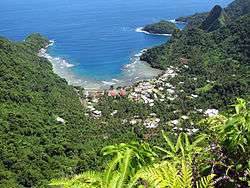
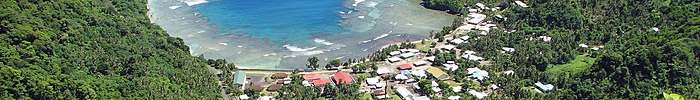
Āfono is a village on the northeast coast of Tutuila Island, American Samoa. One of the island's more populous villages, it is located on the edge of Afono Bay, at the eastern edge of the National Park of American Samoa. It is connected by Highway 6 to Vatia, which lies along the coast to the northwest, and to Aua, on the edge of Pago Pago Harbor to the south via a winding stretch of highway which crosses the spine of the island.
Āfono | |
|---|---|
Village | |
| Afonotele | |
 | |
 Āfono | |
| Coordinates: 14°15′51″S 170°39′3″W | |
| Country | |
| Territory | |
| County | Sua[1] |
| Area | |
| • Total | 1 sq mi (3 km2) |
| Elevation | 85 ft (26 m) |
| Population (2010) | |
| • Total | 524 |
| • Density | 450/sq mi (170/km2) |
Geography
Āfono is a village on the north shore of Tutuila Island in American Samoa, located by Āfono Bay. Āfono is situated over Āfono Pass, which sits in-between Rainmaker Mountain and the Maugaloa Ridge. The village is home to traditional thatched huts.[2] It is reached by following Highway 6 northbound from the village of Aua. The road from Aua includes several steep switchbacks up to Rainmaker Pass, and continues equally steeply down to the village of Āfono.[3] The village borders the Tutuila-section of National Park of American Samoa.
National Park
Access to the Tutuila unit of the National Park of American Samoa is primarily through a paved road which runs along the perimeter of the upper end of Pago Pago Harbor. Lateral roads lead to Fagasā Pass and the park's western end and to Āfono Pass at its eastern end. The latter lateral road also leads to the villages of Āfono and Vatia. Road signs marking entrance points to the National Park unit have been placed along the Āfono/Vatia road near Matape Hill/Craggy Point, near the park boundary in the vicinity of Āfono Pass, and above the village's western side.[4] A National Park Service visitor center has been proposed in Āfono.
The stands of endemic broadleaf forest located between Fagasā and Āfono provide habitat for large numbers of native bird species. The best and biggest known roost on Tutuila Island for the Sheath-tailed bat is located in the Anape'ape Cove near Āfono. Two decades ago 10,000 sheath-tailed bats were occupying the caves.[5]
Lands within the Tutuila unit presently under cultivation for substance agriculture are confined to areas above Āfono and Vatia villages.[6]
Demographics
| Population growth[7] | |
|---|---|
| 2010 | 524 |
| 2000 | 530 |
| 1990 | 434 |
| 1980 | 284 |
| 1970 | 278 |
| 1960 | 184 |
| 1950 | 169 |
| 1940 | 138 |
| 1930 | 96 |
See also
References
- Krämer, Augustin (2000). The Samoa Islands. University of Hawaii Press. Page 424. ISBN 9780824822194.
- "Archived copy". Archived from the original on 2018-05-01. Retrieved 2017-10-26.CS1 maint: archived copy as title (link)
- Swaney, Deanna (1990). Samoa, Western & American Samoa. Lonely Planet Publications. Page 146. ISBN 9780864420787.
- U.S. Department of the Interior/National Park Service (1997). ”National Park of American Samoa, General Management Plan (GP), Islands of Tutulla, Ta'u, and Ofu: Environmental Impact Statement.” Pages 21 and 31.
- U.S. Department of the Interior/National Park Service (1997). ”National Park of American Samoa, General Management Plan (GP), Islands of Tutulla, Ta'u, and Ofu: Environmental Impact Statement.” Pages 129 and 131.
- U.S. Department of the Interior/National Park Service (1997). ”National Park of American Samoa, General Management Plan (GP), Islands of Tutulla, Ta'u, and Ofu: Environmental Impact Statement.” Page 145.
- "American Samoa Statistical Yearbook 2016" (PDF). American Samoa Department of Commerce. Archived from the original (PDF) on 2019-02-14. Retrieved 2019-07-25.
| Topics | |||||
|---|---|---|---|---|---|
| Geography | |||||
| Politics |
| ||||
| Economy |
| ||||
| Culture |
| ||||
| Districts |
| ||||
| Islands | |||||
| Villages |
| ||||