List of counties in Oklahoma
The U.S. state of Oklahoma has 77 counties. It is ranked 20th in size and 17th in the number of counties, between Mississippi with 82 counties and Arkansas with 75 counties.[1]
| Counties of Oklahoma | |
|---|---|
| Location | State of Oklahoma |
| Number | 77 |
| Populations | 2,475 (Cimarron) – 718,633 (Oklahoma) |
| Areas | 371 square miles (960 km2) (Marshall) – 2,251 square miles (5,830 km2) (Osage) |
| Government | County government |
| Subdivisions | cities, towns, unincorporated communities, Indian reservations, census designated place civil townships (Statehood until mid 1930s) |
Oklahoma originally had seven counties (Logan, Cleveland, Oklahoma, Canadian, Kingfisher, Payne, and Beaver) when it was first organized as the Oklahoma Territory. These counties were designated numerically, first through seventh. New counties added after this were designated by letters of the alphabet. The first seven counties were later renamed. The Oklahoma Constitutional Convention named all of the counties that were formed when Oklahoma entered statehood in 1907. Only two counties have been formed since then.[2] Upon statehood, all Oklahoma counties allowed civil townships within their counties. A few years after statehood, a constitutional amendment allowed them to be abolished on a county-by-county basis, and by the mid-1930s, all Oklahoma counties had voted to do so.[3]
According to the Oklahoma Constitution, a county can be disorganized if the sum of all taxable property is less than $2.5 million. If so, then a petition must be signed by one-fourth of the population and then a vote would occur. If a majority votes for dissolution of the county, the county will be combined with an adjacent county with the lowest valuation of taxable property.[4]
The Federal Information Processing Standard (FIPS) code, which is used by the United States government to uniquely identify counties, is provided with each entry. The FIPS code for each county links to census data for that county.
The area in these tables is land area, and does not include water area.
Oklahoma's postal abbreviation is OK and its FIPS state code is 40.
Alphabetical list
| County |
FIPS code[5] | County seat[6] | Est.[6] | Origin | Etymology[7] | Density |
Population[8] | Area[6] | Map |
|---|---|---|---|---|---|---|---|---|---|
| Adair County | 001 | Stilwell | 1907 | Cherokee lands[9] | William Penn Adair, Cherokee tribal leader and Confederate colonel in the American Civil War[9] | 39.38 | 22,683 | 576 sq mi (1,492 km2) | 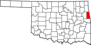 |
| Alfalfa County | 003 | Cherokee | 1907 | Woods County | William H. "Alfalfa Bill" Murray, ninth Governor of Oklahoma[10] | 6.51 | 5,642 | 867 sq mi (2,246 km2) | 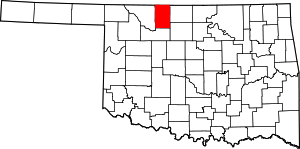 |
| Atoka County | 005 | Atoka | 1907 | Choctaw lands | Captain Atoka, a noted Choctaw leader and signer of the Treaty of Dancing Rabbit Creek[11] | 14.5 | 14,182 | 978 sq mi (2,533 km2) |  |
| Beaver County | 007 | Beaver | 1890 | Seventh County (entire panhandle until 1907)[12] | The Beaver River[13] | 3.11 | 5,636 | 1,814 sq mi (4,698 km2) |  |
| Beckham County | 009 | Sayre | 1907 | Greer County and Roger Mills County[14] | J. C. W. Beckham, Governor of Kentucky[14] | 24.52 | 22,119 | 902 sq mi (2,336 km2) | 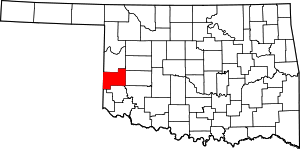 |
| Blaine County | 011 | Watonga | 1890 | Part of Cheyenne and Arapaho reservation.[15] | James G. Blaine, Speaker of the U. S. House of Representatives, U.S. Senator and Secretary of State[16] | 12.86 | 11,943 | 929 sq mi (2,406 km2) | 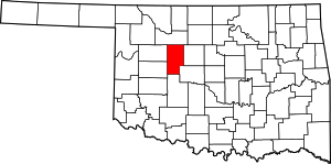 |
| Bryan County | 013 | Durant | 1907 | Choctaw lands | William Jennings Bryan, Secretary of State, famous orator and three-time U.S. Presidential candidate[17] | 46.66 | 42,416 | 909 sq mi (2,354 km2) |  |
| Caddo County | 015 | Anadarko | 1901 | Indian Territory | From Indian word "Kaddi" meaning life or chief[18] | 23.16 | 29,600 | 1,278 sq mi (3,310 km2) |  |
| Canadian County | 017 | El Reno | 1901 | Part of Cheyenne and Arapaho reservation[19] | The Canadian River.[20] | 128.38 | 115,541 | 900 sq mi (2,331 km2) | 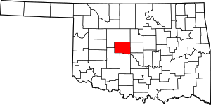 |
| Carter County | 019 | Ardmore | 1907 | Pickens County, Chickasaw Nation | A prominent family of early settlers[21] | 57.71 | 47,557 | 824 sq mi (2,134 km2) | 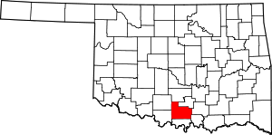 |
| Cherokee County | 021 | Tahlequah | 1907 | Originally settled by Cherokee Indians following the Trail of Tears | Cherokee Nation of Indians[22] | 62.57 | 46,987 | 751 sq mi (1,945 km2) | 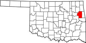 |
| Choctaw County | 023 | Hugo | 1907 | Choctaw Nation | Choctaw Nation of Indians[23] | 19.64 | 15,205 | 774 sq mi (2,005 km2) | 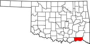 |
| Cimarron County | 025 | Boise City | 1907 | Seventh County (entire panhandle until 1907)[12] | Cimarron River[24] | 1.34 | 2,475 | 1,835 sq mi (4,753 km2) |  |
| Cleveland County | 027 | Norman | 1890 | County 3 in Oklahoma Territory. | Grover Cleveland, twice President of the United States[25] | 477.15 | 255,755 | 536 sq mi (1,388 km2) | 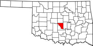 |
| Coal County | 029 | Coalgate | 1907 | Atoka County, Choctaw Nation | Coal, the primary economic product of the region at the time[26] | 11.44 | 5,925 | 518 sq mi (1,342 km2) | 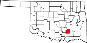 |
| Comanche County | 031 | Lawton | 1907 | Kiowa, Comanche, and Apache reservation | Spanish "Camino Ancho", meaning broad trail[27] | 116.09 | 124,098 | 1,069 sq mi (2,769 km2) |  |
| Cotton County | 033 | Walters | 1912 | Lands of Quapaws, Choctaws, Chickasaws, Comanche Reservation, and Big Pasture | The principal economic base of the county, cotton[28] | 9.72 | 6,193 | 637 sq mi (1,650 km2) |  |
| Craig County | 035 | Vinita | 1907 | Cherokee Nation | Granville Craig, a prominent Cherokee planter[29] | 19.75 | 15,029 | 761 sq mi (1,971 km2) | 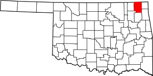 |
| Creek County | 037 | Sapulpa | 1907 | Creek Nation | Creek Nation of Indians[30] | 73.19 | 69,967 | 956 sq mi (2,476 km2) | 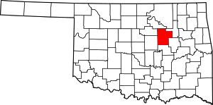 |
| Custer County | 039 | Arapaho | 1891 | Cheyenne-Arapaho Reservation | George A. Custer, United States Army cavalry commander during the Indian Wars[31] | 27.83 | 27,469 | 987 sq mi (2,556 km2) | 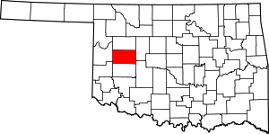 |
| Delaware County | 041 | Jay | 1907 | Delaware District of Cherokee Nation | Delaware Nation of Indians [2] | 55.99 | 41,487 | 741 sq mi (1,919 km2) | 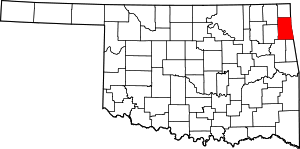 |
| Dewey County | 043 | Taloga | 1892 | Cheyenne-Arapaho Reservation | Admiral George Dewey, hero of the Spanish–American War[32] | 4.81 | 4,810 | 1,000 sq mi (2,590 km2) | 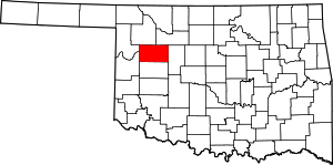 |
| Ellis County | 045 | Arnett | 1907 | Roger Mills and Woodward counties | Albert H. Ellis, member of the Oklahoma Constitutional Convention and first state Legislature[33] | 3.38 | 4,151 | 1,229 sq mi (3,183 km2) | 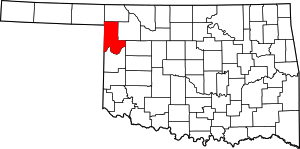 |
| Garfield County | 047 | Enid | 1893 | Cherokee Outlet | James Garfield, President of the United States[34] | 57.26 | 60,580 | 1,058 sq mi (2,740 km2) | 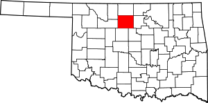 |
| Garvin County | 049 | Pauls Valley | 1907 | Chickasaw Nation | Samuel Garvin, a prominent Chickasaw Indian and local merchant[35] | 34.09 | 27,576 | 809 sq mi (2,095 km2) | 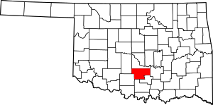 |
| Grady County | 051 | Chickasha | 1907 | Pickens County, Chickasaw Nation | Henry W. Grady, editor of the Atlanta Constitution[36] | 47.62 | 52,431 | 1,101 sq mi (2,852 km2) | 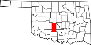 |
| Grant County | 053 | Medford | 1892 | County L | Ulysses S. Grant, President of the United States[37] | 4.52 | 4,527 | 1,001 sq mi (2,593 km2) | 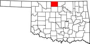 |
| Greer County | 055 | Mangum | 1896 | Greer County, Texas | John Alexander Greer, Lieutenant Governor of Texas[38] | 9.76 | 6,239 | 639 sq mi (1,655 km2) |  |
| Harmon County | 057 | Hollis | 1909 | Greer County | Judson Harmon, U.S. Attorney General and Governor of Ohio[39] | 5.43 | 2,922 | 538 sq mi (1,393 km2) |  |
| Harper County | 059 | Buffalo | 1893 | Woodward County | Oscar G. Harper, clerk of the Oklahoma Constitutional Convention[40] | 3.55 | 3,685 | 1,039 sq mi (2,691 km2) | 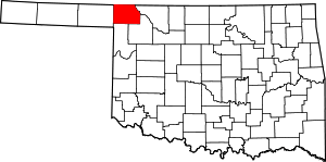 |
| Haskell County | 061 | Stigler | 1907 | San Bois County of the Choctaw Nation | Charles N. Haskell, first Governor of Oklahoma[41] | 22.13 | 12,769 | 577 sq mi (1,494 km2) |  |
| Hughes County | 063 | Holdenville | 1907 | Choctaw Nation and Creek Nation lands | William C. Hughes, member of the Oklahoma Constitutional Convention[2][42] | 17.35 | 14,003 | 807 sq mi (2,090 km2) | 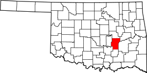 |
| Jackson County | 065 | Altus | 1907 | Greer County | Either Stonewall Jackson, Confederate general during the American Civil War[43] or Andrew Jackson, seventh President of the United States[2] | 32.93 | 26,446 | 803 sq mi (2,080 km2) |  |
| Jefferson County | 067 | Waurika | 1907 | Comanche County and part of Chickasaw Nation | Thomas Jefferson, third President of the United States[44] | 8.53 | 6,472 | 759 sq mi (1,966 km2) | 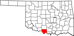 |
| Johnston County | 069 | Tishomingo | 1907 | Chickasaw Nation land | Douglas H. Johnston, Governor of the Chickasaw Nation[45] | 16.99 | 10,957 | 645 sq mi (1,671 km2) | 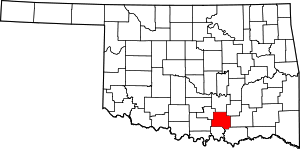 |
| Kay County | 071 | Newkirk | 1895 | County K, Cherokee Strip | Originally designated as county "K"[46] | 50.67 | 46,562 | 919 sq mi (2,380 km2) |  |
| Kingfisher County | 073 | Kingfisher | 1907 | Unassigned Lands | Either for the kingfisher bird[2] or King David Fisher, an early settler in the area[47] | 16.65 | 15,034 | 903 sq mi (2,339 km2) |  |
| Kiowa County | 075 | Hobart | 1901 | Kiowa-Comanche-Apache Indian Reservations | Kiowa Nation of Indians [48] | 9.31 | 9,446 | 1,015 sq mi (2,629 km2) |  |
| Latimer County | 077 | Wilburton | 1907 | Choctaw Nation land | James S. Latimer, member of the Oklahoma Constitutional Convention[49] | 15.45 | 11,154 | 722 sq mi (1,870 km2) | 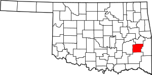 |
| Le Flore County | 079 | Poteau | 1907 | Choctaw Nation[50] | A Choctaw Indian family of French descent[2] | 31.77 | 50,384 | 1,586 sq mi (4,108 km2) |  |
| Lincoln County | 081 | Chandler | 1891 | County A in Oklahoma Territory | Abraham Lincoln, the sixteenth president of the United States | 35.74 | 34,273 | 959 sq mi (2,484 km2) | 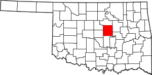 |
| Logan County | 083 | Guthrie | 1891 | County 1 in Oklahoma Territory | John A. Logan, American Civil War general | 56.17 | 41,848 | 745 sq mi (1,930 km2) | 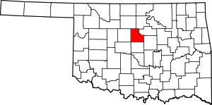 |
| Love County | 085 | Marietta | 1907 | Pickens County, Chickasaw Nation, Indian Territory | Overton Love, Chickasaw judge and prominent landowner | 18.3 | 9,423 | 515 sq mi (1,334 km2) |  |
| Major County | 093 | Fairview | 1909 | Woods County, Oklahoma Territory | John C. Major, member of the Oklahoma Constitutional Convention | 7.87 | 7,527 | 957 sq mi (2,479 km2) | 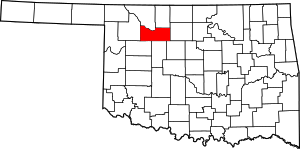 |
| Marshall County | 095 | Madill | 1907 | Pickens County, Chickasaw Nation, Indian Territory[51] | The maiden name of a member of the Constitutional Convention's mother | 42.7 | 15,840 | 371 sq mi (961 km2) | 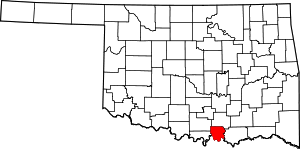 |
| Mayes County | 097 | Pryor | 1907 | Saline District, Cherokee Nation[52] | Cherokee leader Samuel Houston Mayes | 62.89 | 41,259 | 656 sq mi (1,699 km2) | 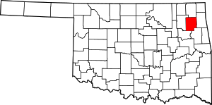 |
| McClain County | 087 | Purcell | 1907 | Choctaw Nation land | Charles M. McClain, member of the Oklahoma Constitutional Convention | 60.54 | 34,506 | 570 sq mi (1,476 km2) | 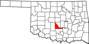 |
| McCurtain County | 089 | Idabel | 1907 | [53] | The McCurtain family, a prominent Choctaw landowning group | 17.9 | 33,151 | 1,852 sq mi (4,797 km2) | 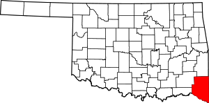 |
| McIntosh County | 091 | Eufaula | 1907 | Creek Nation land[54] | The McIntosh family, a prominent Creek landowning group | 32.66 | 20,252 | 620 sq mi (1,606 km2) | 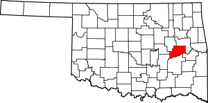 |
| Murray County | 099 | Sulphur | 1907 | Chickasaw Nation land | Governor of Oklahoma William H. "Alfalfa Bill" Murray | 32.27 | 13,488 | 418 sq mi (1,083 km2) |  |
| Muskogee County | 101 | Muskogee | 1907 | Muskogee District of Creek Nation and part of Illinois and Canadian Districts of Cherokee Nation[55] | Muskogee Nation of Indians | 87.21 | 70,990 | 814 sq mi (2,108 km2) | 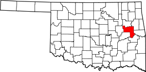 |
| Noble County | 103 | Perry | 1897 | County P in Oklahoma Territory.[56] | U.S. Secretary of the Interior John W. Noble | 15.79 | 11,561 | 732 sq mi (1,896 km2) | 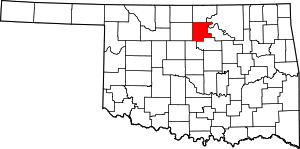 |
| Nowata County | 105 | Nowata | 1907 | Cooweescoowee District of Cherokee Nation[57] | The town of Nowata, Oklahoma. The exact origin is unknown, but the two most common stories are that railroad surveyors used the Delaware word noweta for welcome or that a sign was posted indicating that local springs had no water: No wata | 18.65 | 10,536 | 565 sq mi (1,463 km2) | 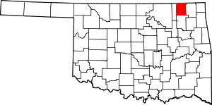 |
| Okfuskee County | 107 | Okemah | 1907 | Creek Nation land | Creek town of the same name in Cleburn County, Alabama | 19.51 | 12,191 | 625 sq mi (1,619 km2) |  |
| Oklahoma County | 109 | Oklahoma City | 1891 | Unassigned Lands in Indian Territory, the County 2 in Oklahoma Territory[58] | From two Choctaw words okla and humma, meaning people and red | 1,013.59 | 718,633 | 709 sq mi (1,836 km2) | 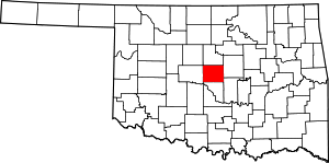 |
| Okmulgee County | 111 | Okmulgee | 1907 | Creek Nation land | Creek word meaning boiling water | 57.49 | 40,069 | 697 sq mi (1,805 km2) |  |
| Osage County | 113 | Pawhuska | 1907 | Coterminous with Osage Reservation | The Osage Indian Reservation, inhabited by the Osage Nation | 21.09 | 47,472 | 2,251 sq mi (5,830 km2) | 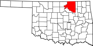 |
| Ottawa County | 115 | Miami | 1907 | Multiple tribal reservations in Indian Territory.[59] | Ottawa Native American people | 67.62 | 31,848 | 471 sq mi (1,220 km2) | 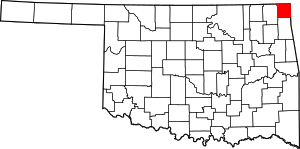 |
| Pawnee County | 117 | Pawnee | 1897 | Cherokee Outlet, then County Q in Oklahoma Territory[60] | The Skidi Pawnee Native American people | 29.08 | 16,577 | 570 sq mi (1,476 km2) | 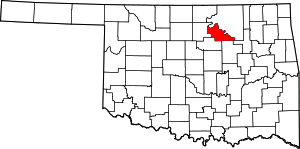 |
| Payne County | 119 | Stillwater | 1890 | County 6 in Oklahoma Territory in 1889, renamed to Payne County in 1907[61] | David L. Payne, the key figure in opening Oklahoma to white settlement | 112.76 | 77,350 | 686 sq mi (1,777 km2) | 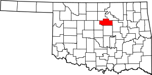 |
| Pittsburg County | 121 | McAlester | 1907 | Choctaw Nation land[62] | Pittsburgh, Pennsylvania | 35.1 | 45,837 | 1,306 sq mi (3,383 km2) |  |
| Pontotoc County | 123 | Ada | 1907 | Chickasaw Nation[63] | Pontotoc is a Chickasaw word meaning cat tails growing on the prairie | 52.07 | 37,492 | 720 sq mi (1,865 km2) |  |
| Pottawatomie County | 125 | Shawnee | 1891 | Creek Nation and Seminole Nation lands.[64] | The Pottawatomie Native American people | 88.12 | 69,442 | 788 sq mi (2,041 km2) | 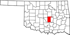 |
| Pushmataha County | 127 | Antlers | 1907 | Pushmataha District of the Choctaw Nation[65] | The Pushmataha District of the Choctaw Nation | 8.28 | 11,572 | 1,397 sq mi (3,618 km2) | 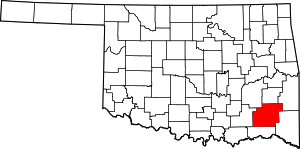 |
| Roger Mills County | 129 | Cheyenne | 1895 | County F in Oklahoma Territory[66] | U.S. Senator Roger Q. Mills | 3.19 | 3,647 | 1,142 sq mi (2,958 km2) | 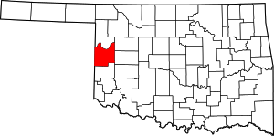 |
| Rogers County | 131 | Claremore | 1907 | Cooweescoowee District, Cherokee Nation, Indian Territory[67] | Clem V. Rogers, a member of the Oklahoma Constitutional Convention and the father of entertainer Will Rogers | 128.75 | 86,905 | 675 sq mi (1,748 km2) | 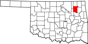 |
| Seminole County | 133 | Wewoka | 1907 | Seminole Nation[68] | The Seminole Native American people | 40.32 | 25,482 | 632 sq mi (1,637 km2) | 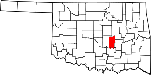 |
| Sequoyah County | 135 | Sallisaw | 1907 | Sequoyah District and part of Illinois District, Cherokee Nation | Sequoyah (George Guess), invented the Cherokee syllabary[69] | 62.89 | 42,391 | 674 sq mi (1,746 km2) | 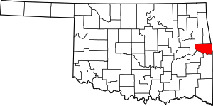 |
| Stephens County | 137 | Duncan | 1907 | Comanche County, Oklahoma Territory | John Hall Stephens, a Texas congressman and advocate of Oklahoma statehood | 51.37 | 45,048 | 877 sq mi (2,271 km2) |  |
| Texas County | 139 | Guymon | 1907 | Seventh County (entire panhandle until 1907)[12] | The neighboring U.S. state of Texas | 10.13 | 20,640 | 2,037 sq mi (5,276 km2) |  |
| Tillman County | 141 | Frederick | 1907 | Comanche County, Oklahoma[70] | U.S. Senator Benjamin Tillman of South Carolina | 9.17 | 7,992 | 872 sq mi (2,258 km2) | 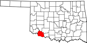 |
| Tulsa County | 143 | Tulsa | 1907 | Cherokee Nation and Creek Nation land. | Derived from Tulsey Town, Alabama, an old Creek settlement. | 1,058.6 | 603,403 | 570 sq mi (1,476 km2) | 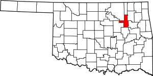 |
| Wagoner County | 145 | Wagoner | 1907 | Cherokee Nation land[71] | Bailey P. Waggoner, attorney of the Missouri Pacific Railroad, which established the town of Wagoner[7] | 129.81 | 73,085 | 563 sq mi (1,458 km2) | 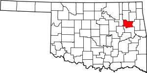 |
| Washington County | 147 | Bartlesville | 1907 | Cooweescoowee District of Cherokee Nation.[72] | First President of the United States George Washington | 122.24 | 50,976 | 417 sq mi (1,080 km2) | 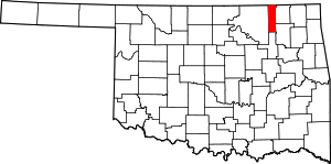 |
| Washita County | 149 | Cordell | 1897 | County H in Oklahoma Territory[73] | The Washita River | 11.58 | 11,629 | 1,004 sq mi (2,600 km2) |  |
| Woods County | 151 | Alva | 1893 | County M in Oklahoma Territory.[74] | Kansas populist and territorial legislator Samuel Newitt Wood | 6.9 | 8,878 | 1,287 sq mi (3,333 km2) | 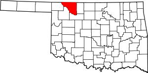 |
| Woodward County | 153 | Woodward | 1893 | County N in Oklahoma Territory[75] | Santa Fe Railroad director B. W. Woodward | 16.17 | 20,081 | 1,242 sq mi (3,217 km2) | 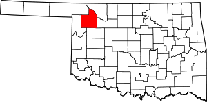 |
References
- "How Many Counties are in Your State?". Click and Learn. Archived from the original on 2009-04-22. Retrieved 2009-08-26.
- "Origin of County Names in Oklahoma". Chronicles of Oklahoma. 2 (1): 75–82. March 1924. Archived from the original on 2017-08-14. Retrieved 2007-02-28.
- "Wagoner County - 1928 - 1937". www.ok.gov. Retrieved 2017-11-03.
- "The Constitution of the State of Oklahoma," Article XVII, Section 5. http://oklegal.onenet.net/okcon/XVII-5.html. Accessed on 2007-02-28.
- "EPA County FIPS Code Listing". EPA.gov. Retrieved 2008-02-23.
- National Association of Counties. "NACo – Find a county". Archived from the original on 2012-03-31. Retrieved 2011-09-30.
- Oklahoma Historical Society. "Origin of County Names in Oklahoma" Archived 2017-08-14 at the Wayback Machine, Chronicles of Oklahoma 2:1 (March 1924) 75–82 (retrieved August 18, 2006)
- "P1 Population Total – All counties within Oklahoma". US Census Bureau. 2010. Archived from the original on 2020-02-12. Retrieved 2011-09-30.
- Whitaker, Rachel, "Adair County Archived 2010-07-28 at the Wayback Machine," Encyclopedia of Oklahoma History and Culture Archived 2010-05-31 at the Wayback Machine (accessed June 21, 2010).
- "Alfalfa". Oklahoma Encyclopedia Online (PDF). Oklahoma Department of Libraries. 2005. Retrieved 2007-02-28.
- "Atoka". Oklahoma Encyclopedia Online (PDF). Oklahoma Department of Libraries. 2005. Retrieved 2007-02-28.
- Turner, Kenneth, "No Man's Land," Encyclopedia of Oklahoma History and Culture Archived 2010-05-31 at the Wayback Machine (accessed June 21, 2010).
- "Beaver". Oklahoma Encyclopedia Online (PDF). Oklahoma Department of Libraries. 2005. Retrieved 2007-02-28.
- "Beckham". Oklahoma Encyclopedia Online (PDF). Oklahoma Department of Libraries. 2005. Retrieved 2007-02-28.
- Wilson, Linda D., "Blaine County Archived 2010-07-18 at the Wayback Machine," Encyclopedia of Oklahoma History and Culture Archived 2010-05-31 at the Wayback Machine (accessed June 21, 2010).
- "Blaine". Oklahoma Encyclopedia Online (PDF). Oklahoma Department of Libraries. 2005. Retrieved 2007-02-28.
- "Bryan". Oklahoma Encyclopedia Online (PDF). Oklahoma Department of Libraries. 2005. Retrieved 2007-02-28.
- "Caddo". Oklahoma Encyclopedia Online (PDF). Oklahoma Department of Libraries. 2005. Retrieved 2007-03-04.
- "Canadian". Oklahoma Encyclopedia Online (PDF). Oklahoma Department of Libraries. 2005. Retrieved 2007-03-04.
- Oklahoma Historical Society. "Origin of County Names in Oklahoma" Archived 2017-08-14 at the Wayback Machine, Chronicles of Oklahoma 2:1 (March 1924) 75-82 (retrieved August 18, 2006).
- "Carter". Oklahoma Encyclopedia Online (PDF). Oklahoma Department of Libraries. 2005. Retrieved 2007-03-04.
- "Cherokee". Oklahoma Encyclopedia Online (PDF). Oklahoma Department of Libraries. 2005. Retrieved 2007-03-04.
- "Choctaw". Oklahoma Encyclopedia Online (PDF). Oklahoma Department of Libraries. 2005. Retrieved 2007-03-04.
- "Cimarron". Oklahoma Encyclopedia Online (PDF). Oklahoma Department of Libraries. 2005. Retrieved 2007-03-04.
- "Cleveland". Oklahoma Encyclopedia Online (PDF). Oklahoma Department of Libraries. 2005. Retrieved 2007-03-04.
- "Coal". Oklahoma Encyclopedia Online (PDF). Oklahoma Department of Libraries. 2005. Retrieved 2007-03-04.
- "Comanche". Oklahoma Encyclopedia Online (PDF). Oklahoma Department of Libraries. 2005. Retrieved 2007-03-04.
- "Cotton". Oklahoma Encyclopedia Online (PDF). Oklahoma Department of Libraries. 2005. Retrieved 2007-03-04.
- "Craig". Oklahoma Encyclopedia Online (PDF). Oklahoma Department of Libraries. 2005. Retrieved 2007-03-04.
- "Creek". Oklahoma Encyclopedia Online (PDF). Oklahoma Department of Libraries. 2005. Retrieved 2007-03-04.
- "Custer". Oklahoma Encyclopedia Online (PDF). Oklahoma Department of Libraries. 2005. Retrieved 2007-03-04.
- "Dewey". Oklahoma Encyclopedia Online (PDF). Oklahoma Department of Libraries. 2005. Retrieved 2007-03-04.
- Debo, Angie. "Albert H. Ellis" (PDF). Chronicles of Oklahoma. Retrieved 2013-05-18.
- "Garfield". Oklahoma Encyclopedia Online (PDF). Oklahoma Department of Libraries. 2005. Retrieved 2007-03-04.
- "Garvin". Oklahoma Encyclopedia Online (PDF). Oklahoma Department of Libraries. 2005. Retrieved 2007-03-04.
- "Grady". Oklahoma Encyclopedia Online (PDF). Oklahoma Department of Libraries. 2005. Retrieved 2007-03-04.
- "Grant". Oklahoma Encyclopedia Online (PDF). Oklahoma Department of Libraries. 2005. Retrieved 2007-03-04.
- "Greer". Oklahoma Encyclopedia Online (PDF). Oklahoma Department of Libraries. 2005. Retrieved 2007-03-04.
- "Harmon". Oklahoma Encyclopedia Online (PDF). Oklahoma Department of Libraries. 2005. Retrieved 2007-03-04.
- "Harper". Oklahoma Encyclopedia Online (PDF). Oklahoma Department of Libraries. 2005. Retrieved 2007-04-02.
- "Haskell". Oklahoma Encyclopedia Online (PDF). Oklahoma Department of Libraries. 2005. Retrieved 2007-04-02.
- "Hughes". Oklahoma Encyclopedia Online (PDF). Oklahoma Department of Libraries. 2005. Retrieved 2007-04-02.
- "Jackson". Oklahoma Encyclopedia Online (PDF). Oklahoma Department of Libraries. 2005. Retrieved 2007-04-02.
- "Jefferson". Oklahoma Encyclopedia Online (PDF). Oklahoma Department of Libraries. 2005. Retrieved 2007-04-02.
- "Johnston". Oklahoma Encyclopedia Online (PDF). Oklahoma Department of Libraries. 2005. Retrieved 2007-04-02.
- "Kay". Oklahoma Encyclopedia Online (PDF). Oklahoma Department of Libraries. 2005. Retrieved 2007-04-02.
- "Kingfisher". Oklahoma Encyclopedia Online (PDF). Oklahoma Department of Libraries. 2005. Retrieved 2007-04-02.
- "Kiowa". Oklahoma Encyclopedia Online (PDF). Oklahoma Department of Libraries. 2005. Retrieved 2007-04-02.
- "Latimer". Oklahoma Encyclopedia Online (PDF). Oklahoma Department of Libraries. 2005. Retrieved 2007-04-02.
- "Le Flore". Oklahoma Encyclopedia Online (PDF). Oklahoma Department of Libraries. 2005. Retrieved 2007-04-02.
- O'Dell, Larry. Encyclopedia of Oklahoma History and Culture. "Marshall County." Retrieved August 13, 2013.
- Carney, Amanda. Encyclopedia of Oklahoma History and Culture. "Mayes County." Archived 2013-05-27 at the Wayback Machine Retrieved September 14, 2011.
- Coleman, Louis.Encyclopedia of Oklahoma History and Culture. "McClain County" Archived 2013-09-14 at the Wayback Machine. Retrieved April 2, 2011.
- O'Dell, Larry. "McIntosh County". Oklahoma Historical Society. Oklahoma History Center. Retrieved 6 February 2016.
- Mullins, Jonita. Encyclopedia of Oklahoma History and Culture. "Muskogee County." Archived 2013-10-04 at the Wayback Machine Retrieved April 22, 2013.
- Everett, Dianna. Encyclopedia of Oklahoma History and Culture. "Noble County." Archived 2013-10-05 at the Wayback Machine Retrieved October 3, 2013.
- Cheatham, Gary L. Encyclopedia of Oklahoma History and Culture: "Nowata County." Archived 2013-09-28 at the Wayback Machine Retrieved October 1, 2011.
- Wilson, Linda D. Encyclopedia of Oklahoma History and Culture. "Oklahoma County." Archived 2013-09-14 at the Wayback Machine Accessed September 17. 2009
- O'Dell, Larry. Encyclopedia of Oklahoma History & Culture. "Ottawa County." Archived 2013-10-04 at the Wayback Machine Retrieved February 16, 2009.
- Encyclopedia of Oklahoma History and Culture. "Pawnee County" Archived 2012-11-19 at the Wayback Machine Retrieved February 26,/2011
- Newsome, D. Earl. Encyclopedia of Oklahoma History and Culture. "Payne County." Retrieved March 29, 2012. Archived 2013-10-05 at the Wayback Machine
- O'Dell, Larry. Encyclopedia of Oklahoma History and Culture. "Pittsburg County." Retrieved September 29, 2013.
- Turner, Alvin O. Encyclopedia of Oklahoma History and Culture. "Pontotoc County." Retrieved September 29, 2013.
- Mullins, William H. Encyclopedia of Oklahoma History and Culture. "Pottawatomie County." Archived 2012-12-21 at the Wayback Machine Retrieved February 26, 2011
- Milligan, James C. Encyclopedia of Oklahoma History and Culture. "Pushamataha County." Retrieved October 3, 2013.
- Wilson, Linda D. Encyclopedia of Oklahoma History & Culture. "Roger Mills County". Oklahoma Historical Society.
- Thomas, Sarah C. Encyclopedia of Oklahoma History and Culture "Rogers County. Retrieved September 19, 2011."
- Mullins, William H. Encyclopedia of Oklahoma History and Culture. "Seminole County." Retrieved October 1, 2013.
- Anderson, William L. Encyclopedia of Oklahoma History and Culture. "Sequoyah County." Archived 2014-06-05 at the Wayback Machine Accessed May 23, 2012.
- Wilson, Linda D. Encyclopedia of Oklahoma History and Culture. "Tillman County." Retrieved October 3, 2013.
- McMahan, Liz. "Wagoner County – Encyclopedia of Oklahoma History & Culture". Oklahoma Historical Society. Archived from the original on 26 May 2011. Retrieved 24 May 2011.
- May, Jon D. Encyclopedia of Oklahoma History and Culture. "Washington County."
- O'Dell, Larry. Encyclopedia of Oklahoma History and Culture. "Washita County."
- Reichenberger, Donovan. Encyclopedia of Oklahoma History and Culture. "Woods County." Retrieved January 1, 2013.
- Everett, Dianna. Encyclopedia of Oklahoma History and Culture. "Woodward County." Accessed September 12, 2013
Oklahoma City (capital) | ||
| Topics |
|  |
| Society |
| |
| Regions | ||
| Largest cities | ||
| Counties |
| |