Lealataua County
Lealataua County is a county in the Western District in American Samoa.[1][2][3]

Map of Tutuila where Lealataua County is highlighted in red, while the Western District is marked in orange.
Demographics
| Year | Pop. | ±% |
|---|---|---|
| 1912 | 1,163 | — |
| 1920 | 1,134 | −2.5% |
| 1930 | 1,256 | +10.8% |
| 1940 | 1,625 | +29.4% |
| 1950 | 2,201 | +35.4% |
| 1960 | 2,393 | +8.7% |
| 1970 | 3,145 | +31.4% |
| 1980 | 3,581 | +13.9% |
| 1990 | 5,106 | +42.6% |
| 2000 | 5,684 | +11.3% |
| 2010 | 5,103 | −10.2% |
| U.S. Decennial Census[4] | ||
Lealataua County was first recorded beginning with the 1912 special census. Regular decennial censuses were taken beginning in 1920.[5]
Villages
Landmarks
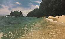
A beach between Poloa and 'Āmanave.
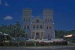
Siona Church in Leone.
- Atauloma Girls School, in Atauloma
- Cape Taputapu National Natural Landmark, westernmost point on Tutuila Island
- Fagalele Boys School: May be the oldest building on Tutuila Island.
- Leone Congregational Christian Church (Siona), church in Leone with a historic monument dedicated to John Williams
- Leone Falls, waterfall in Leone
- Leone Healing Garden, in Leone
- Mauga o Alii (Mountain of Chiefs), in Leone
- Palagi Beach, beach in 'Āmanave
- Poloa Defensive Fortifications, in Poloa
- Tataga-Matau Fortified Quarry Complex, in Leone
References
- "CPH-T-8. Population, Housing Units, Land Area, and Density for U.S. Island Areas: 2010" (PDF). United States Census. Retrieved 4 February 2019.
- 1987 Census of Agriculture: Geographic area series, Parts 55-56. Bureau of the Census. p. 4.
- "5.0102 Division of districts into counties". www.asbar.org.
- "U.S. Decennial Census". Census.gov. Archived from the original on May 12, 2015. Retrieved June 6, 2013.
- https://www2.census.gov/prod2/decennial/documents/41084484v3ch10.pdf
This article is issued from Wikipedia. The text is licensed under Creative Commons - Attribution - Sharealike. Additional terms may apply for the media files.