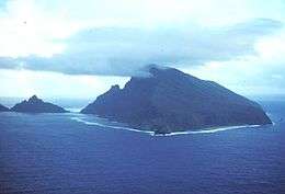
Ofu-Olosega
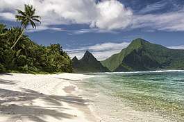
Ofu and Olosega are parts of a volcanic doublet in the Manu‘a Group of the Samoan Islands—part of American Samoa. The twin islands, formed from shield volcanoes, have a combined length of 6 km and an area of 12 square kilometers (5 square miles); their population is about 500 people. They are geographic volcanic remnants separated by the narrow 137-meter-wide (449-foot) Āsaga Strait, a natural bridge of shallow coral reef. Before 1970, one had to wade between the two islands at low tide; now a single-lane road bridge over the strait connects villages on Ofu island with those on Olosega.
| Ofu-Olosega | |
|---|---|
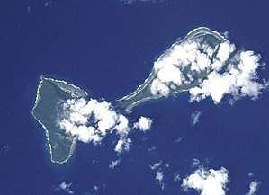 Ofu-Olosega from the Space Shuttle | |
| Highest point | |
| Elevation | 639 m (2,096 ft) |
| Prominence | 639 m (2,096 ft) |
| Coordinates | 14.175°S 169.618°W |
| Geography | |
| Location | American Samoa |
| Topo map | USGS |
| Geology | |
| Mountain type | Shield volcanoes |
| Last eruption | September to November 1866 |
The highest peak on Ofu is Mount Tumutumu (491 m (1,611 ft), also referred to as Tumu) and the highest elevation on Olosega is Mount Piumafua (629 m (2,064 ft)). The most recent volcanic eruption took place in 1866, 3 km (1.9 mi) south east of Olosega.[1]
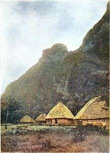
Archaeology field work carried out in the 1980s yielded pre-historic evidence including ceramics, adzes, shell and bone which have been significant in furthering understanding of the ancient history of the Samoa Islands and Polynesia. This included samples of red-slipped plainware ceramics that appeared to be in the tradition of the Lapita culture. The work, carried out by a team that included Pacific archaeology specialist Patrick Vinton Kirch, focused on a site called To'aga (site AS-13-1), a 2 km (1.2 mi) coastal stretch on the south coast of Ofu. The results showed continuous human habitation of about 3,000 years.[2]
Ofu
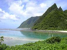
Ofu is the western part of the volcanic outcrop of Ofu-Olosega Island and the westernmost of the Manu'a Islands.[3] The main village of Ofu is located on the western shore, protected behind an offshore islet (eroded tuff cone) known as Nu'utele. Ofu has a small airport (IATA: OFU, ICAO: NSAS) and a boat harbor that serve the population on Ofu and Olosega. The weekly flight from Pago Pago takes about half an hour.
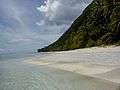
Most of the southern shore and associated coral reef are part of the National Park of American Samoa. In 2005 the U.S. National Park Service was negotiating with village councils on Olosega to expand the park around that island.
The island forms the Ofu County subdivision of the Manua District. It has a land area of 7.215 km² (2.786 sq mi), and had an official population of 176 persons as of the 2010 census.
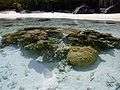
Situated on the south coast of the island is To'aga lagoon which has a high diversity of corals and fishes. The marine site has been part of long term research and study on coral reefs and global climate change.
The island is also home to the Samoa Flying-fox (Pteropus samoensis), a species of bat threatened by habitat loss.
Olosega
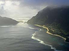
Olosega is the smallest island in Manu'a. It is possible to walk across to Ofu Island at low tide.[4][5]
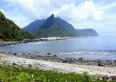
Olosega Island is a remnant of the Sili shield volcano, the caldera of which may lie submerged off the north shore.
The volcanic eruption of 1866 was actually 3 km (1.9 mi) east of Olosega, on a submarine ridge that extends east southeast to nearby Ta‘ū.
The island forms the Olosega County subdivision of the Manua District. It has a land area of 5.163 km² (1.993 sq mi), and had an official population of 172 persons as of the 2010 census.
There are four villages on Olosega: Olosega, Lalomoana, Sili and Faiava.
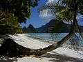
Gallery
See also
- Archaeology in Samoa
- Manu'a Islands
References
- "Global Volcanism Program, Ofu-Olosega". Smithsonian National Museum of Natural History. Retrieved 13 July 2010.
- Jason Tyler, Patric V. Kirch, Terry L. Hunt, Lisa Nagaoka (November 1989). "Final Report on Archaeological Investigations at Site AS-13-1, To'aga, Ofu Island, American Samoa". Department of Parks and Recreation, Government of American Samoa. Retrieved 13 July 2010.
- Hills, J.W. (2010). O upu muamua i le Tala i le Lalolagi mo e ua faatoa a'oa'oina u lea mataupu: Elementary Geography. Nabu Press. Page 63. ISBN 9781147952896.
- Hills, J.W. (2010). O upu muamua i le Tala i le Lalolagi mo e ua faatoa a'oa'oina u lea mataupu: Elementary Geography. Nabu Press. Page 63. ISBN 9781147952896.
- Holmes, Lowell D. (1974). Samoan Village. Holt McDougal. Page 3. ISBN 9780030779251.
External links
- Office of the Governor. 2004. Manu‘a ma Amerika. A brief historical documentary. Manu‘a Centennial. 16 July 1904. 16 July 2004. Office of the Governor, American Samoa Government. 20 p.
- "Ofu-Olosega". Global Volcanism Program. Smithsonian Institution.
- Ofu County and Olosega County, Manu'a District, United States Census Bureau
- National Park Service map of the Manu‘a Islands
- Persistence of Coral Reefs Under Extreme Environmental Stress in American Samoa G. Piniak, C. Birkeland, and G. Garrison (2004). University of Hawaii.
Back Bay Sharks U12-The Fasí Crew-Rugby
| Topics | |||||
|---|---|---|---|---|---|
| Geography | |||||
| Politics |
| ||||
| Economy |
| ||||
| Culture |
| ||||
| Districts |
| ||||
| Islands | |||||
| Villages |
| ||||