Wendover
Wendover is a market town and civil parish at the foot of the Chiltern Hills in Buckinghamshire, England. It is situated at the point where the main road across the Chilterns between London and Aylesbury intersects with the once important road along the foot of the Chilterns. The town is some 35 miles (56 km) north west of London and 5 miles (8 km) south east of Aylesbury, and is very popular with commuters working in London.[2][3]
| Wendover | |
|---|---|
The Clock Tower, Wendover | |
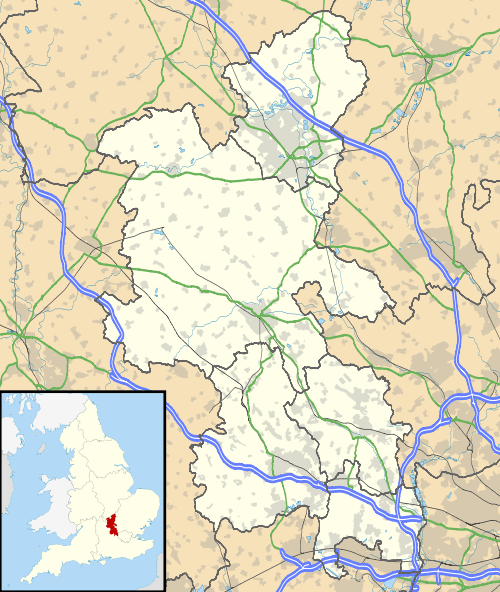 Wendover Location within Buckinghamshire | |
| Area | 9.1125 sq mi (23.601 km2) |
| Population | 7,399 (2011 Census)[1] |
| • Density | 812/sq mi (314/km2) |
| OS grid reference | SP864085 |
| Civil parish |
|
| Unitary authority | |
| Ceremonial county | |
| Region | |
| Country | England |
| Sovereign state | United Kingdom |
| Post town | AYLESBURY |
| Postcode district | HP22 |
| Dialling code | 01296 |
| Police | Thames Valley |
| Fire | Buckinghamshire |
| Ambulance | South Central |
| UK Parliament | |
| Website | Wendover Parish Council |
The parish has an area of 5,832 acres (2,360 ha) and had, at the time of the 2011 census, a population of 7,399.[1] Outside the town of Wendover, the parish is mainly arable and also contains many hamlets that nestle amongst the woodlands on the surrounding hills. Although Wendover has a weekly market, and has had a market charter since medieval times, many of its inhabitants identify it as a village, and the parish council does not describe itself as a town council.[2]
Etymology
The town name is of Brittonic origin and means "white water", composed of the elements winn, "white", and duẞr, "water" (Welsh gwyn-dwfr), referring to the stream that rises in the adjacent hills and flows through the middle of the town, bringing chalk deposits on its way.[4]
History
The first known documentary reference to Wendover, then known as Wændofron, is in the will of Ælfheah, the ealdorman of Hampshire, and dates from between 965 and 971. Prior to the Norman Conquest, the manor, which at the time measured 24 hides in area, was held by Edward the Confessor. The settlement appears to have been centred some 600 metres (2,000 ft) to the south of the present-day focus of the town, near the current location of the parish church of St Mary. By 1086 the manor of Wendovre was in the hundred of Aylesbury, with William the Conqueror as its tenant in chief.[2][5][6]
The manor remained in royal ownership until 1154, and then passed back and forth between royal and private ownership several times. Wendover was granted a market charter in 1214, and had become a borough by 1228, although it does not appear to have achieved any degree of self-government. It is likely that around this time the focus moved north to its current location, allowing the market to cater to traffic on the road running along the Chilterns between Chinnor and Tring, as well as that crossing the Chilterns between London and Aylesbury. The current layout of the older parts of the town show clear signs of medieval town planning, especially the presence of long, narrow and rectilinear burgage plots.[2][5]
Both parliamentary and royalist forces visited the town during the Civil War, with looting reported by both sides. Many of the buildings in the town centre, and especially on High Street, Pound Street, and Aylesbury Road, date from the 17th century. It is not known whether this is because they needed rebuilding after civil war damage, or is an indication of the prosperity of the town at the time.[2][5]
.jpg)
In 1721, the Wendover to Buckingham Turnpike Trust was established, and Wendover became a stop for coach routes to and from London. It is likely that at this time a number of new inns and hostelries were built along the High Street. The Wendover Arm of the Grand Union Canal was built between 1793 and 1797 and served local industries whilst also providing a water supply for the parent canal. In September 1892, the railway reached the town with the opening of Wendover Railway Station on the Metropolitan Railway's line to Aylesbury. Responsibility for the station was transferred from London Transport, who had inherited it from the Metropolitan Railway, to British Railways, in 1961.[2][7]
The 1841 census reveal the population that year was 1,877.[8]
In 1913, Alfred de Rothschild, invited the Royal Flying Corps to conduct manoeuvres on his land in the adjacent manor of Halton, and the land continued to be used by the British Army throughout the First World War. In 1916 the Royal Flying Corps moved its air mechanics school from Farnborough, Hampshire to Halton, and in 1917, the school was permanently accommodated there, in what was to become the current RAF Halton. Whilst the base is not in the parish of Wendover, its close proximity impacted on the town, and the surrounding landscape, due to the associated population increases and deforestation to provide wood for construction work.[2][9][10]
In the latter part of the twentieth century, a number of large scale residential developments appeared, particularly to the north of the town. In 1998, the Wendover bypass was built, moving the A413 road west of the town centre, paralleling the railway line. Property values rose significantly in the years after the completion of the bypass, which removed a lot of traffic from the town's narrow streets. In 2010, the proposed route the High Speed 2 rail line (HS2) from London to the Midlands was published, showing it taking a route in tunnel to the west of the bypass and town centre. As part of a wider campaign against the route, a Wendover lobby group was formed, with a 300 strong protest filmed by the BBC in December 2010. However, despite the opposition, the HS2 bill was passed in 2016, and construction contracts let in 2017.[2][11][12][13][14][15]
Geography
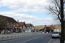
Wendover lies at approximately 130 metres (430 ft) above sea level. It occupies a prime position at the northern end of a natural crossing point through the Chiltern Hills, which wrap around the west, south and east of the town. To the north the land slopes gently downwards towards the flat, agricultural land of the Aylesbury Vale. To the west the town is overlooked by Coombe Hill (260 metres or 850 feet) and to the east by Wendover Woods (267 metres or 876 feet).[2][16]
.jpg)
The gap through the Chilterns that Wendover sits astride has long been an important communications route. It is used by the A413 road between London and Aylesbury, the London to Aylesbury railway line, and the new high speed rail link between London and the North that is now under construction. At Wendover this route is crossed by the route of the ancient Icknield Way, running along the line of the Chilterns, that has connected Wiltshire to Norfolk since prehistoric times.[2][5][16]
Besides the town itself, the civil parish includes the hamlets of:
- Dean, located south of Wendover on Smalldean Lane between the hamlets of Smalldean and Little London.[16]
- Kings Ash or Kingsash, located south-south east of Wendover on the Chesham Lane between the A413 road and the hamlet of Lee Gate.[16]
- Little London, located south of Wendover on Smalldean Lane between the hamlet of Dean and the village of Dunsmore.[16]
- Lower Bacombe, located south of Wendover on the lane between the main town and Upper Bacombe.[16]
- Smalldean, located south of Wendover on Smalldean Lane, between the southernmost roundabout of the Wendover bypass and the hamlet of Dean.[16]
- The Hale, located east of Wendover along Hale Lane.[16]
- Upper Bacombe, located south-south west of Wendover on Bacombe Hill, close of the parish boundary.[16]
- Wendover Dean, located south of Wendover on the A413 road, between Cobblershill Lane and Bowood Lane.[16]
- World's End, located north west of Wendover where the B4009 road meets the A413 road.[16]
Governance
Wendover was represented by its own parliamentary constituency, intermittently from 1300 and continuously from 1660, until the seat was abolished by the Reform Act of 1832. The town and parish now form part of the Aylesbury parliamentary constituency.[17] This has elected a Conservative Member of Parliament (currently David Lidington) since 1924.
For the purposes of local government, Wendover has its own parish council, but also lies within the district of Aylesbury Vale and the county of Buckinghamshire.[18][19] Local elections, as in May 2011, often feature only Conservative, Liberal Democrat and independent candidates.
The Wendover Parish Council, re-elected in May 2015, has a small office in the town and operates a block grant from Aylesbury Vale District Council.
Economy
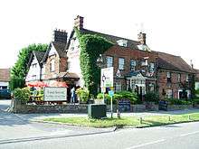
Facilities in the village centre include a post office, several hairdressers, a community library (run by volunteers), a deli & cafe, a pharmacy, and a charity shop. There is a weekly open market on Thursdays.
Wendover was well known for its diverse range of pubs, but many of these have now closed due to the constraints and geographics of the day. The pubs still open today are The Red Lion, The George & Dragon, The White Swan, The King and Queen, The Pack Horse, The Village Gate (formerly the Marquis of Granby) and The Shoulder of Mutton. The Red Lion pub was home to 'Britain's Oldest Barmaid', 100-year-old Dolly Saville, who worked at the pub for 76 years.
Landmarks
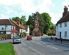
There are 113 listed buildings in Wendover, of which five are listed at the higher grade II* and the remainder are all listed at grade II. The five grade II* buildings are the parish church, the lychgate of that church, Bank Farmhouse, the Hale and the Red House.[20]
There is a distinctive red brick, spired clock tower at the crossroads in the centre of the town, built in 1842. To the north of this cross-roads, the tree-lined Aylesbury Street includes the 16th-century timber framed Chiltern House and 18th-century Red House.
To the north of the town centre is the terminus of the Wendover Arm of the Grand Union Canal, which joins Tring summit level of the Grand Union main line beside Marsworth top lock. Disused for over a century, the arm is in the course of being restored by the Wendover Arm Trust.[21] Remote and rural for almost all its length, the canal attracts much local wildlife, including a colony of mandarin ducks. It is possible to walk along the canal for about 5 miles (8.0 km) from the centre of Wendover, to Tring.
.jpg)
To the south of town centre lie the open spaces of Witchell Meadow, Hampden Meadow and Rope Walk Meadow, the latter hosting the new Wendover Community Orchard in memory of the First World War. These are bounded to the east by the Heron Stream and to the south by Hampden Pond, both feeders to the canal. On the southern side of the pond lies Wendover's parish church, which is dedicated to St Mary, and which marks the site of the original settlement.[2]
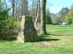
The town is sited in a gap in the Chiltern Hills and a designated Area of Outstanding Natural Beauty. The ancient Ridgeway National Trail, an 85-mile walking route from Avebury to Ivinghoe, passes along Wendover High Street. Apart from the Ridgeway Trail there are 33 miles of public rights of way and bridleways criss-crossing the parish and leading to the open chalk downland of Coombe Hill, Buckinghamshire, home to Britain's longest surviving geocache, and a monument to the Buckinghamshire men who died in the Boer War. Wendover Woods on Haddington Hill and Boddington Hill belong to Forest Enterprise England. There are routes for mountain bikers, and walking trails for walkers of various abilities as well as barbecue sites and play areas for children. Close to Boddington Hill are the remains of an Iron Age hill fort.[22]
Wendover and the surrounding villages including Aston Clinton, Ellesborough and Weston Turville, are widely regarded as exceptionally desirable places to reside and the town was named one of the best places to live in Britain by The Sunday Times in 2018.[23][24]
Transport
The town has easy access to London by rail, with Wendover station hosting Chiltern Railways services to and from London Marylebone on the London to Aylesbury Line.[3]
Wendover has two bus routes passing through it: the 50 travels between Aylesbury and RAF Halton and the 55 travels between Aylesbury and Chesham. Both services are run by Arriva.
The High Speed 2 rail line from London to the North will take a route immediately to the west of Wendover, passing through a tunnel roughly parallel to, and to the west of, the existing by-pass road and railway. At its closest point, the tunnel will be some 300 metres (980 ft) from the end of the High Street.[12]
Education
There are four schools in the town:
- The John Hampden School, named after politician and English Civil War participant John Hampden, a community infant school with about 275 pupils aged 4–7,
- Wendover Church of England Junior School, a voluntary controlled junior school with about 360 pupils aged 7–11,
- The John Colet School, named after the Renaissance humanist John Colet, a community secondary school with about 1100 pupils aged 11–18,
- The Wendover campus of the Chiltern Way Academy, a special school for pupils aged 11–18.
Sport
Wendover Football Club was founded over 100 years ago. The club currently shares the school fields of the John Colet School and a clubhouse is open each Saturday afternoon for either a first or a reserve team fixture. The team strip is gold and black stripes. Former midfield star Bruno Passaro is club chairman.
Wendover also plays host to the 'Coombe Hill Run', usually held on the first Sunday in June. It begins and ends in the village and includes two very steep climbs up the hill to the monument along with a very steep decline.
Notable people
- Thomas Barlow (1845–1945), physician[25]
- Edmund Burke (1729-1797), member of parliament
- Gordon Onslow Ford (1912–2003), artist[26]
- David Jason (1940–), actor[27]
- John Junkin (1930–2006), actor and scriptwriter[28]
- Geoffrey Palmer (1927–), actor
- Cecilia Payne-Gaposchkin (1900–1979), astronomer and astrophysicist[29]
- Margaret Rawlings (1906–1996), actress[30]
- Michael Shrimpton (1957–), barrister[31]
- Roger of Wendover (?–1236), chronicler[32]
- Steven Wendover
Twin town
References
- "Key Figures for 2011 Census: Key Statistics". Neighbourhood Statistics. Retrieved 2 February 2013.
- "Wendover Conservation Area" (PDF). Aylesbury Vale District Council. December 2011. Archived (PDF) from the original on 24 August 2018. Retrieved 24 August 2018.
- "Let's move to ... Wendover, Bucks". The Guardian. Retrieved 16 May 2009.
- John T. Baker, Cultural Transition in the Chilterns and Essex Region, P159, Wendover is a pre-English name made up of the Britonic 'winn' meaning 'white, fair, holy' and 'duẞr' meaning 'waters'.
- "The borough of Wendover". Victoria County History - Buckinghamshire. 1925. Retrieved 24 August 2018.
- "Wendover". Open Domesday Online. Retrieved 24 August 2018.
- The Railway Magazine, August 2013 edition (page 47), ISSN 0033-8923
- The National Cyclopaedia of Useful Knowledge, Vol.III, London, Charles Knight, p.899
- Bowyer, Michael (1983). Action Stations 6; Military Airfields of the Cotswolds and Central Midlands. Patrick Stephens Limited. p. 148. ISBN 0-85059-529-0.
- "Plane sailing at airshow". Buckinghmshire Herald. 18 June 2008. Retrieved 31 July 2017.
- "High-speed rail plans announced by government". BBC News. 11 March 2010. Retrieved 11 March 2010.
- "Map 9 - Route from Wendover Dean to Stoke Mandeville – drawing number HS2-ARP-00-DR-RW-05009" (PDF). Department for Transport. 5 January 2012. Retrieved 17 April 2012.
- "Wendover HS2 « Opposing HS2 routes through the Chilterns". Wendoverhs2.org. Retrieved 22 April 2013.
- "HS2 Hybrid Bill receives Royal Assent".
- "Major HS2 construction contracts signed". Rail Technology Magazine. 2 August 2017.
- Ordnance Survey (2015). OS Explorer Map 181 - Chiltern Hills North - Aylesbury, Berkhamsted & Chesham. ISBN 9780319243749.
- "Election Maps (with civil parish and constituency boundaries shown)". Ordnance Survey. Retrieved 29 August 2018.
- "Election Maps (with civil parish and district boundaries shown)". Ordnance Survey. Retrieved 29 August 2018.
- "Election Maps (with civil parish and county boundaries shown)". Ordnance Survey. Retrieved 29 August 2018.
- "Listed Buildings in Wendover, Aylesbury Vale, Buckinghamshire". British Listed Buildings. Retrieved 31 August 2018.
- "Restoring canal history in the Chilterns". Wendover Arm Trust. Retrieved 17 April 2012.
- Kidd, Sandy. "Bucks Archaeological Service Later Bronze Age and Iron Age Historic Environment Resource Assessment". CiteSeerX 10.1.1.613.8671. Cite journal requires
|journal=(help) - "Wendover, Buckinghamshire-best places to live in the UK 2018". The Sunday Times. 18 March 2018. Retrieved 18 March 2018.
- "Wendover shortlisted as one of the best places to live in Britain by newspaper survey". Bucks Herald. 16 March 2018. Retrieved 16 March 2018.
- "Papers of Barlow, Sir Thomas". Jisc. Retrieved 28 August 2018.
- "Gordon Onslow Ford". The Solomon R. Guggenheim Foundation. Retrieved 28 August 2018.
- "Wendover's Sir David Jason opens up about his life". The Bucks Herald. 3 November 2013. Retrieved 28 August 2018.
- "Tribute: John Junkin". Wendover News. 28 August 2006. Retrieved 28 August 2018.
- Gingerich, O. (1982). "Cecilia Payne-Gaposchkin". Quarterly Journal of the Royal Astronomical Society. 23: 450. Bibcode:1982QJRAS..23..450G.
- Benedick, Adam (4 June 1996). "Obituary: Margaret Rawlings". Independent. Retrieved 28 August 2018.
- "Barrister sparked security scare by 'claiming Nazis wanted to blow up the Queen at the 2012 Olympics'". The Daily Telegraph. London. 10 November 2014. Retrieved 19 September 2016.
- Encyclopedia Britannica. (1911 edition) Volume V23, Page 455
- "British towns twinned with French towns". Archant Community Media Ltd. Retrieved 11 July 2013.
External links
| Wikivoyage has a travel guide for Wendover. |
| Wikimedia Commons has media related to Wendover. |
