Skardu–Kargil Road
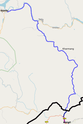
The Skardu–Kargil Road (Urdu: سکردو – کرگل سڑک) is 126 km provincial highway of Gilgit-Baltistan linking Skardu with Kharmang.[1] The original road continued on to Kargil from Kharmang parallel to the Shingo River, but has since been closed down since 1949.[2] Part of the road on the Indian side of the LOC is now in India's NH1.
| Skardu–Kargil Road سکردو – کرگل سڑک | |
|---|---|
 | |
| Route information | |
| Maintained by Planning & Development Department Border Roads Organisation | |
| Length | 126 km (78 mi) |
| Major junctions | |
| From | Skardu |
| To | Kargil |
| Location | |
| Towns | Kharmang |
| Highway system | |
| Roads in Pakistan | |
History
Prior to independence, the regions of Kargil, Leh and Baltistan constituted regional provinces of Jammu and Kashmir princely state called the Ladakh Wazarat. The road from Skardu to Kargil was part of the ancient Silk Route. The 1949 ceasefire resulted in fragmenting Ladakh and Baltistan. Many families still trace their immediate ancestors on the other side of the border.[3] Many people from both sides of the Line of Control seek to have the road reopened to traffic.[4][5]
References
- http://www.dailytimes.com.pk/opinion/01-Sep-2015/opening-the-kargil-skardu-road
- https://www.thenews.com.pk/archive/print/5483-political-debris-blocking-the-skardu-kargil-road
- http://www.greaterkashmir.com/news/opinion/kargil-skardu-road-only-connect/187225.html
- "Refugees seek opening of Skardu, Kargil road". Dawn. 27 June 2006. Retrieved 2 February 2020.
- https://www.dawn.com/news/615159
