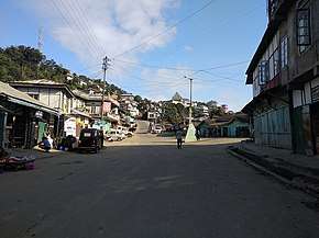
National Highway 102B (India)
National Highway 102B, commonly referred to as NH 102B is a national highway in India.[1][2][3] It is a spur road of National Highway 2.[4] NH-102B traverses the states of Manipur and Mizoram in India.[3][5] It is known as Guite road by Gazette Order of the Government of Manipur.[6]
| ||||
|---|---|---|---|---|
 NH 102B at Ngopa zero point | ||||
| Route information | ||||
| Auxiliary route of NH 2 | ||||
| Length | 323 km (201 mi) | |||
| Major junctions | ||||
| North end | Churachandpur | |||
| South end | Keifang | |||
| Location | ||||
| States | Manipur, Mizoram | |||
| Highway system | ||||
| ||||
Junctions
gollark: Some obvious things: 50 votes, Project COMPARTMENTAL SLATS, Project NUMERATE POLYMERS, baidicoot briefly being admin, r9k-test, Epicbot being continuously unavailable.
gollark: I don't care enough to actually find a list of things to put on it.
gollark: I agree.
gollark: Well, if you write a script, I can run it through my TTS thing and apply vaguely relevant images.
gollark: You can present things differently based on your biases about them.
References
- "New highways notification dated March, 2012" (PDF). The Gazette of India - Ministry of Road Transport and Highways. Retrieved 10 July 2018.
- "National highway 102B route substitution" (PDF). The Gazette of India - Ministry of Road Transport and Highways. Retrieved 29 July 2018.
- "State-wise length of National Highways (NH) in India as on 30.06.2017". Ministry of Road Transport and Highways. Retrieved 10 July 2018.
- "New Numbering of National Highways notification - Government of India" (PDF). The Gazette of India. Retrieved 10 July 2018.
- "Unserviceable Condition of National Highway-102B in Manipur". Press Information Bureau - Government of India. 21 February 2014. Retrieved 10 July 2018.
- "JAC Starts Repairing Guite Road at Churachandpur in Manipur". Northeast Today. Retrieved 10 July 2018.
This article is issued from Wikipedia. The text is licensed under Creative Commons - Attribution - Sharealike. Additional terms may apply for the media files.


