San Francisco Bay National Estuarine Research Reserve
The San Francisco Bay National Estuarine Research Reserve (San Francisco Bay NERR) is one of 27 reserves established as part of the United States National Estuarine Research Reserve System. The reserve is used to promote San Francisco Bay wetlands and estuary research, education, and stewardship.

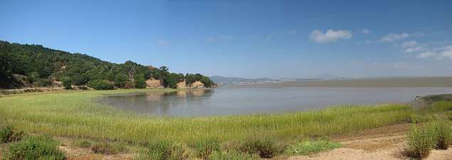
Bay view from China Camp Park, part of the San Francisco Bay National Estuarine Research Reserve
Organization
The reserve is a partnership between National Oceanic and Atmospheric Administration (NOAA), San Francisco State University, California State Parks, Solano Land Trust, and the San Francisco Bay Conservation and Development Commission.[1]

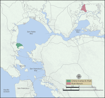
Map of San Francisco Bay National Estuarine Research Reserve sites
Reserve sites
The San Francisco Bay NERR consists of two sites in the San Francisco Bay Area: [2]
- Rush Ranch Open Space Preserve — 2,070-acre (8.4 km2), on the northern margin of Suisun Marsh, at the western foot of the Potrero Hills, in Solano County.
- China Camp State Park — 1,640-acre (6.6 km2), on the shore of San Pablo Bay near San Rafael in Marin County.
gollark: The technical term as used in the PotatOS Privacy Policy™ is PotatOS Things™.
gollark: Jesus™ is a registered trademark of osmarks network systems™.
gollark: Oh, that is a rate limit, you'll have to wait... go with an hour.
gollark: Deploying apioĦazards.
gollark: ++apioform <@!402456897812168705>
See also
- Estuarine
- Estuaries of California
- Wetlands of the San Francisco Bay Area
References
- "San Francisco Bay NERR :: Welcome!". Retrieved 2009-03-25.
- "San Francisco Bay NERR :: Reserve Sites". Archived from the original on 2009-09-05. Retrieved 2009-03-25.
External links
- Official San Francisco Bay National Estuarine Research Reserve (San Francisco Bay NERR) website
- Map of San Francisco Bay NERR
- NOAA National Estuarine Research Reserve System website: San Francisco Bay NERR webpage
| |||||||||||||||||||||
| |||||||||||||||||||||
| |||||||||||||||||||||
| |||||||||||||||||||||
| |||||||||||||||||||||
| |||||||||||||||||||||
| |||||||||||||||||||||
| |||||||||||||||||||||
| Outline |
|  |
|---|---|---|
| Subdivisions | ||
| Waterways |
| |
| Parks and protected areas |
| |
| Islands and peninsulas |
| |
| Wetlands | ||
| Bridges and tubes | ||
| Ferries | ||
| Ports and marinas | ||
| Other |
| |
| ||
| Bodies of water |
|  |
|---|---|---|
| Counties | ||
| Major cities | ||
| Cities and towns 100k–250k | ||
| Cities and towns 50k–99k | ||
| Cities and towns 25k–50k | ||
| Cities and towns 10k–25k |
| |
| Sub-regions | ||
This article is issued from Wikipedia. The text is licensed under Creative Commons - Attribution - Sharealike. Additional terms may apply for the media files.