São Vicente Ferrer, Pernambuco
São Vicente Ferrer is a Brazilian municipality in the state of Pernambuco. According with IBGE in 2009, has an estimated population of 17,333 inhabitants. It has a total area of 110.49 square kilometres (42.66 sq mi).
São Vicente Ferrer | |
|---|---|
 Flag | |
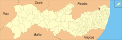 Location in Pernambuco state | |
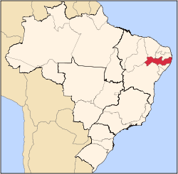
 São Vicente Ferrer Location in Brazil | |
| Coordinates: 7°35′27″S 35°29′27″W | |
| Country | Brazil |
| Region | Northeast |
| State | Pernambuco |
| Area | |
| • Total | 110.49 km2 (42.66 sq mi) |
| Elevation | 419 m (1,375 ft) |
| Population (2009) | |
| • Total | 17,333 |
| • Density | 160/km2 (410/sq mi) |
| Time zone | UTC-03:00 (BRT) |
Geography
- State - Pernambuco
- Region - Agreste of Pernambuco
- Boundaries - Macaparana (N), Machados (S) Vicência (E); Orobó and Paraiba state (W).
- Area - 110.49 km2
- Elevation - 419 m
- Hydrography - Goiana River
- Vegetation - Subcaducifólia forest
- Annual average temperature - 23.1 °C
- Distance to Recife - 131 km
Economy
The main economic activities in São Vicente Ferrer are related with commerce and agribusiness, especially creations of cattle; and plantations of bananas, grapes and sugarcane.
Economic Indicators
| Population [1] | GDP x(1000 R$).[2] | GDP pc (R$) | PE |
|---|---|---|---|
| 17.333 | 63.254 | 3.811 | 0.103% |
Economy by Sector 2006
| Primary sector | Secondary sector | Service sector |
|---|---|---|
| 34.95% | 6.19% | 58.86% |
Health Indicators
| HDI (2000) | Hospitals (2007) | Hospitals beds (2007) | Children's Mortality every 1000 (2005) |
|---|---|---|---|
| 0.598 | 1 | 29 | 24.2 |
gollark: Computerized voting: because computer systems never have big security problems, and trusting elections to closed source voting machines is totally fine!
gollark: I'm not sure why the presidential candidates' age needs to be brought into this when they all seem bad in other ways anyway.
gollark: That would make sense.
gollark: I'm not hip and with it (yo) when it comes to all these... generation name things? What's a "doomer"?
gollark: I do generally prefer flying to cars for reasonably long distances, but the whole "security" thing at airports really does a great job at making me reevaluate that. And is not actually improving security at all.
References
- http://www.ibge.gov.br/home/estatistica/populacao/estimativa2009/POP2009_DOU.pdf IBGE Population 2009 S. Vicente Ferrer, page 34]
- S. Vicente Ferrer 2007 GDP IBGE page 32 Archived 2016-03-04 at the Wayback Machine
- PE State site - City by city profile
Capital: Recife | ||||||||||||||
| Mesoregion Agreste Pernambucano |
|  | ||||||||||||
| Mesoregion Mata Pernambucana |
| |||||||||||||
| Mesoregion Metropolitana de Recife |
| |||||||||||||
| Mesoregion Sao Francisco Pernambucano |
| |||||||||||||
| Mesoregion Sertao Pernambucano |
| |||||||||||||
This article is issued from Wikipedia. The text is licensed under Creative Commons - Attribution - Sharealike. Additional terms may apply for the media files.