Lajedo, Pernambuco
Lajedo is a municipality and a city in the state of Pernambuco in Brazil. The population is 39,240 (2015 est.) in an area of 189.10 km².[1] The city area is 3.5 km².
Lajedo | |
|---|---|
 Flag  Coat of arms | |
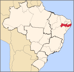
.png) Location in Pernambuco state | |
 Lajedo Location in Brazil | |
| Coordinates: 8°39′50″S 36°19′12″W | |
| Country | Brazil |
| Region | Northeast |
| State | Pernambuco |
| Mesoregion | Agreste Pernambucano |
| Area | |
| • Total | 189.10 km2 (73.01 sq mi) |
| Population (2015) | |
| • Total | 39,240 |
| • Density | 210/km2 (540/sq mi) |
| Time zone | UTC-03:00 (BRT) |
Geography
- Boundaries - São Bento do Una and Cachoeirinha (N); Canhotinho (S); Ibirajuba (E); Calçado (W).
- Elevation - 661 m
- Hydrography - Una and Mundaú River
- Vegetation - Caatinga hiperxerófila
- Annual average temperature - 21.9 c
- Distance to Recife - 192 km
Economy
The main economic activities in Lajedo are industry, commerce and agribusiness, especially farming of cattle, goats, pigs, sheep, chickens; and plantations of beans and manioc.
Villages
- Agrovila Rural
- Cantinho
- Imaculada
- Pau-Ferro
- Pereiro
- Prata
- Quatis
- Retiro
- Santa Luzia
- Olho d'Água dos Pombos
gollark: Hmm. Apparently,> Right-wing politics embraces the view that certain social orders and hierarchies are inevitable, natural, normal, or desirable,[1][2][3] typically supporting this position on the basis of natural law, economics, or tradition.[4]:693, 721[5][6][7][8][9] Hierarchy and inequality may be seen as natural results of traditional social differences[10][11] or competition in market economies.[12][13][14] The term right-wing can generally refer to "the conservative or reactionary section of a political party or system".[15] Obviously, generics should exist in all programming languages ever, since they have existed for quite a while and been implemented rather frequently, and allow you to construct hierarchical data structures like trees which are able to contain any type.
gollark: Ah, I see. Please hold on while I work out how to connect those.
gollark: I refuse. I don't know exactly how it will look on your screen, and I can't write it with RTL characters due to Discorduous limitations and English.
gollark: That is left-justified.
gollark: Generics: excellent. Generality: excellent³. Generals: meh.
References
- Instituto Brasileiro de Geografia e Estatística
- http://www.ibge.gov.br/home/estatistica/populacao/estimativa2009/POP2009_DOU.pdf IBGE Population 2009 Lajedo, page 33]
- Lajedo 2007 GDP IBGE page 30 Archived 2016-03-04 at the Wayback Machine
- PE State site - City by city profile
Capital: Recife | ||||||||||||||
| Mesoregion Agreste Pernambucano |
|  | ||||||||||||
| Mesoregion Mata Pernambucana |
| |||||||||||||
| Mesoregion Metropolitana de Recife |
| |||||||||||||
| Mesoregion Sao Francisco Pernambucano |
| |||||||||||||
| Mesoregion Sertao Pernambucano |
| |||||||||||||
This article is issued from Wikipedia. The text is licensed under Creative Commons - Attribution - Sharealike. Additional terms may apply for the media files.