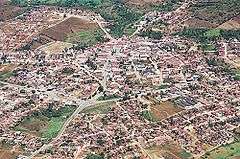
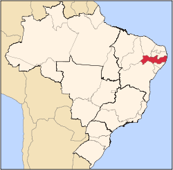
Passira
Geography
- Region - Agreste Pernambucano
- Boundaries - Limoeiro and Salgadinho (N); Gravatá, Bezerros and Pombos (S); Cumaru (W); Feira Nova and Glória do Goitá (E)
- Area - 329.75 km²
- Elevation - 176 m
- Hydrography - Capibaribe river
- Vegetation - Caatinga hipoxerófila
- Climate - semi arid hot
- Average annual temperature - 24.1 °C
- Distance to Recife - 115 km
Economy
The main economic activities in Passira are based in commerce and agribusiness, especially tomatoes, corn and beans, and the rearing of cattle, goats, sheep and horses.
Economic Indicators
| Population [1] | GDP x(1000 R$).[2] | GDP pc (R$) | PE |
|---|---|---|---|
| 28.518 | 80.369 | 2.880 | 0.135% |
Economy by Sector 2006
| Primary sector | Secondary sector | Service sector |
|---|---|---|
| 11.04% | 8.80% | 80.16% |
Health Indicators
| HDI (2000) | Hospitals (2007) | Hospitals beds (2007) | Children's Mortality every 1000 (2005) |
|---|---|---|---|
| 0.625 | 1 | 30 | 21 |
gollark: Have gold prices imploded in some way?
gollark: Oh yes, I forgot that the PotatOS Institute already has one of those.
gollark: *4G*? That's higher-latency and lower-bandwidth!
gollark: How will we control the vaccine nanobots now?
gollark: What?!
References
- http://www.ibge.gov.br/home/estatistica/populacao/estimativa2009/POP2009_DOU.pdf IBGE Population 2009 Passira, page 34]
- Passira 2007 GDP IBGE page 31 Archived 2016-03-04 at the Wayback Machine
- PE State site - City by city profile
Capital: Recife | ||||||||||||||
| Mesoregion Agreste Pernambucano |
|  | ||||||||||||
| Mesoregion Mata Pernambucana |
| |||||||||||||
| Mesoregion Metropolitana de Recife |
| |||||||||||||
| Mesoregion Sao Francisco Pernambucano |
| |||||||||||||
| Mesoregion Sertao Pernambucano |
| |||||||||||||
This article is issued from Wikipedia. The text is licensed under Creative Commons - Attribution - Sharealike. Additional terms may apply for the media files.